Hastings, County of

Taxonomy

Code

Scope note(s)

Display note(s)

Hierarchical terms

Hastings, County of

BT Ontario

Equivalent terms

Hastings, County of

Associated terms

Hastings, County of

1099 Archival description results for Hastings, County of

Only results directly related

Comfort Country Map

The map is entitled "Comfort Country" and highlights vacation areas in Stirling, Tweed, Madoc, Marmora. Advertisements on back with numbers to show on Map where it is located.

Madoc and District Chamber of Commerce

Comfort Country Map

The map is entitled "Comfort Country" and highlights vacation areas in Coehill, Ormsby, Gilmour and the surrounding areas. Advertisements on back with numbers to show on Map where it is located.

Comfort Country Map of Hastings County

A excerpt map from a news paper. The map is entitled "Comfort Country" and highlights vacation areas in Stirling, Tweed, Madoc, Marmora. Advertisements on back with numbers to show on Map where it is located.

Copy of Fire Insurance Map 1878

1878 Fire Insurance Map from Charles Goad's Atlas. Details streets, buildings and lots in Belleville, Ontario. Donated by Beth Green.

Chas. E. Goad Company

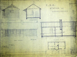
COR Station at Bannockburn Plans

A blueprint planning the COR station at Bannockburn, Hastings County, Ontario. Plan features floor, platform plans, elevation and sections. Drawn by John Dunlop Evans, Chief Surveyor/Engineer - July 19, 1902.

Evans, John Dunlop, P.L.S.

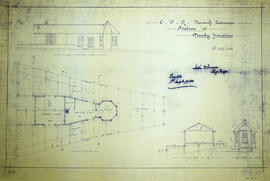
COR Station at Bloomfield Plans

A blueprint planning the COR passenger station at Bloomfield, Hastings County, Ontario. Plan features floor, platform plans, elevation and sections. Drawn by John Dunlop Evans, Chief Surveyor/Engineer - July 24, 1909.

Evans, John Dunlop, P.L.S.

COR Station at Ormsby Plans

A blueprint planning the COR Bancroft extension station at Ormsby junction, Hastings County, Ontario. Plan features floor, elevation and sections. Drawn by John Dunlop Evans, Chief Surveyor/Engineer - September 1, 1900.

Evans, John Dunlop, P.L.S.

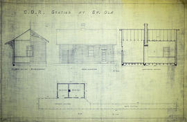
COR Station at St. Ola Plans

A blueprint planning the COR station at St. Ola, Hastings County, Ontario. Plan features floor, elevation and sections.

Discovery Tour of Loyalist Country (pamphlet)

A pamphlet describing a 250km tour of historical attractions within Hastings, Prince Edward, Lennox and Addington counties. The history of each destination (e.g. the Macpherson House) is given, as well as its location on a map.

Ontario Heritage Foundation

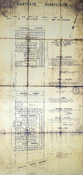
East Gate Subdivision in the City of Belleville

A certified reproduction of the "Subdivision of Part of East ½ of Lot # 13, Concession 1, Township of Thurlow, now Belleville laid out for Maple View Realty Ltd. Pres. Maurice Rollins.” The area includes; Lots # 1 to 110 and Blocks A, B, C, D, E, F and Haig Road, Joyce Crescent, Richmond Grove, Janlyn Crescent, Whalen Court, all east of Haig Road. Surveyed by Walter I. Watson, O. L. S. and signed February 10, 1964.

Donated by Walter I. Watson, P. L. S.

Watson, Walter Irvine, O.L.S.

East Park Subdivision in the City of Belleville

A certified reproduction of the "East Park Subdivision, part of east half of Lot # 13, Concession 1, formerly Township of Thurlow, now Belleville - owner Lambert Rollins Construction.” The area includes; Lots # 1 to 47, Block A-C, east of Haig Road, with Bridge Street East, Joyce Crescent, Freemont Road. Surveyed by T. S. Ransom O. L. S. (of Ransom & Watson, O. L. S.) and signed April 21, 1965.

Donated by Walter I. Watson, P. L. S.

Ransom, Thomas Saunders, P.L.S.

Eastview Heights Subdivision in the City of Belleville

A certified reproduction of the "Subdivision Eastview Heights, part of Lot # 13, Concession 1, Township of Thurlow now City of Belleville.” The area includes; north of Victoria Avenue being Lots # 1 to 25, Blocks A-B laid out on Edge Hill Road, Kingsway Court, Victoria Avenue, and Haig Road. Surveyed by Thomas S. Ransom, O. L. S. and signed May 17, 1963.

Donated by Walter I. Watson, P. L. S.

Ransom, Thomas Saunders, P.L.S.

Results 101 to 120 of 1099