Hastings, County of

Taxonomy

Code

Scope note(s)

Display note(s)

Hierarchical terms

Hastings, County of

BT Ontario

Equivalent terms

Hastings, County of

Associated terms

Hastings, County of

5602 Archival description results for Hastings, County of

1099 results directly related Exclude narrower terms

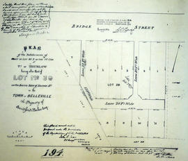
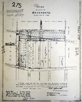
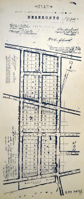
Plan of Allan's Block in the village of Stirling

A certified reproduction of the Plan of Allan's Block, part Lot # 12 in 1st Concession of Township of Rawdon (Stirling). Surveyed by John J. Haslett, P.L.S. in 1853.

This copy was made in 1972 of plan #57, as registered in the Hastings Land Registry Office.

Donated by Walter I. Watson, O.L.S.

Haslett, John James, P.L.S. & D.P.S.

Plan of Alldis Block in the Township of Sidney

A certified reproduction of the "Plan of Alldis Block, part of Lot # 38, Concession 1 Sidney Township, laid out for James Alldis." Surveyed by John D. Evans, P.L.S., and signed November 1874.

This copy was made in 1972 of plan #174, as registered in the Hastings Land Registry Office.

Donated by Walter I. Watson, O.L.S.

Evans, John Dunlop, P.L.S.

Plan of Ashley Cemetery in the Township of Thurlow

A certified reproduction of the "Plan of Ashley Cemetery, as laid out on part of Lot # 2 in 5th Concession, Thurlow, for Harford Ashley.” Plan includes Foxboro on Concession Line between Concession # 5 & 6 on part of Lot # 2 in Concession 5, Thurlow. Surveyed by Evans and Bolger, P. L. S. and dated January 1878.

This copy was made in 1972 of plan #208, as registered in the Hastings Land Registry Office.

Donated by Walter I. Watson, P. L. S.

Evans and Bolger

Plan of Baker's Block in the Town of Belleville

A certified reproduction of the "Plan of subdivision of part of Lot # 3 in 1st Concession Thurlow, being part of Lot # 39 on south side of Bridge Street in Belleville. Property of Sandford Baker and designated Baker's Block.” Surveyed by John D. Evans, P. L. S. Plan registered October 30, 1875.

This copy was made in 1972 of plan #194, as registered in the Hastings Land Registry Office.

Donated by Walter I. Watson, P. L. S.

Evans, John Dunlop, P.L.S.

Plan of Ballyrickard property in the City of Belleville

A certified reproduction of the "Plan of “Ballyrickard.” The property of N. B. Falkiner and A. E. M. Falkiner and composed of part of Lot # 2, Concession 1, Thurlow, now City of Belleville.” Lots # 8, 11, 15 north of Wareham Street, Lot # 10 south of Commercial Street and all of the Willard Estate lying west limit is included. Surveyed by Bolger and Drewry, P.L.S. and dated March 11, 1885.

This copy was made in 1972 of plan #242, as registered in the Hastings Land Registry Office.

Donated by Walter I. Watson, P. L. S.

Bolger and Drewry, P.L.S.

Plan of Belleville Rifle Range

An original oilcloth plan of the "Belleville Rifle Range." The range was located on the waterfront of the Bay of Quinte and from Foster Avenue eastward. Surveyed by Henry Carre, C.E. & O.L.S. and signed at Belleville on June 2, 1896.

The plan received stamps from 3 offices; Henry Carre (Provincial L. Surveyor in Belleville), the Adujtant General's Office of Canada (June 5, 1896), and the Minister of Militia and Defence. Also featured on the plan are distances from the target (in red), streets, Lingham's Wharf, two Islands and a Marsh.

Donated by Col. W. N. Ponton Estate.

Carre, Henry, O.L.S.

Plan of Bell's Block in the Town of Belleville

A certified reproduction of the "Plan of Bell's Block - Lot # 5 on east side of Pinnacle Street in the Town of Belleville." Surveyed by John J. Haslett, P.L.S. and signed May 6, 1850.

This copy was made in 1972 of plan #13, as registered in the Hastings Land Registry Office.

Donated by Walter I. Watson, O.L.S.

Haslett, John James, P.L.S. & D.P.S.

Plan of Birch Island Resorts in the Township of Marmora

A certified reproduction of the "Birch Island Summer Resorts, as laid out on parts of the east halves of Lots # 7-8 in the 1st Concession of Marmora Township. Owners B. Wright, J. A. Shannon, W. F. Bowen, H. R. Pearce.” Surveyed by Fred. W. Wilkins, O. L. S. and signed January 3, 1925.

This copy was made in 1972 of plan #534, as registered in the Hastings Land Registry Office.

Donated by Walter I. Watson, P. L. S.

Wilkins, Frederick William Baiden, O.L.S.

Plan of Bleecker Estate in the Township of Thurlow

A certified reproduction of the "Plan of part of Bleecker Estate, part of west half of Lot # 7 in 1st Concession Thurlow.” The Estate lay north of the Grand Trunk Railway being a re-subdivision of Lots # 8, 9, 10, 11 & 13. Surveyed by Evans and Bolger, P. L. S. Plan registered February 27, 1863.

This copy was made in 1972 of plan #203, as registered in the Hastings Land Registry Office.

Donated by Walter I. Watson, P. L. S.

Evans and Bolger

Plan of Block 6 in the village of Frankford

A certified reproduction of the "Plan of subdivision of Block # 6 in the Village of Frankford.” Surveyed by John D. Evans O. L. S. and dated July 14, 1909.

This copy was made in 1972 of plan #327, as registered in the Hastings Land Registry Office.

Donated by Walter I. Watson, P. L. S.

Evans, John Dunlop, P.L.S.

Plan of Block B in the City of Belleville

A certified reproduction of the "Plan of Block B formerly Block H, Yeomans's Plan of Lot # 1, Concession 1, Township Thurlow, now Belleville, according to Haslett's Plan of Belleville for Horace Yeomans.” Surveyed by William S. Drewry, P.L.S., and dated September 5, 1884.

This copy was made in 1972 of plan #238, as registered in the Hastings Land Registry Office.

Donated by Walter I. Watson, P. L. S.

Drewry, William Stewart, P.L.S.

Plan of Block D in the town of Trenton

A certified reproduction of the "Irvine Block, subdivision of part of Block D, East ½ of Lot # 3 Concession 1, Murray Township, now Town of Trenton, for Honorable George Irvine, of City of Quebec, by his attorney N. B. Falkiner.” Surveyed by William S. Drewry, P.L.S., and dated September 1, 1884.

This copy was made in 1972 of plan #237, as registered in the Hastings Land Registry Office.

Donated by Walter I. Watson, P. L. S.

Drewry, William Stewart, P.L.S.

Plan of Block F Lots in the village of Stilring

A certified reproduction of the "Plan of Lots Laid out on Block F of Stirling - prepared for F. B. Parker; J. Clare Halliwell.” Surveyed by William R. Aylsworth O. L. S. and dated May 16, 1901.

This copy was made in 1972 of plan #326, as registered in the Hastings Land Registry Office.

Donated by Walter I. Watson, P. L. S.

Aylsworth, William Robert, O. L. S.

Plan of block in east end of Belleville

  • CA ON00156 M/M440-1301
  • Item
  • 1 Mar 1951-14 Apr. 1960
  • Part of Map collection

A map showing a plan of survey for lots 4, 5, 6, 7, 8, 9 and lots 37, 38, 39, 40 on the south side of Bridge Street East between Dufferin and Macdonald Avenues in Belleville, Ontario. Surveyed by John T. Ransom on March 1, 1951 and amended April 14, 1960. Scale: 1'':50'.

Ransom, John Thomas, P.L.S.

Plan of Blocks J and H in the town of Deseronto

A certified reproduction of the "Plan of Part of Deseronto, Block J and Block H in part of Lot # 38 and Lot # 39 in Concession 2 and 3. Tyendinaga, for the Rathburn Company the proprietors.” Surveyed by William R. Aylsworth, P.L.S. and dated June 1, 1888.

This copy was made in 1972 of plan #275, as registered in the Hastings Land Registry Office.

Donated by Walter I. Watson, P. L. S.

Aylsworth, William Robert, O. L. S.

Plan of Blocks K and M in the town of Deseronto

A certified reproduction of the "Plan showing of Blocks K and M of Deseronto, on west plot of Lot 3, Concession A, Township of Tyendinaga.” Blocks K and M are from Main Street north to the original Concession Road Allowance, west to Brant Street, and east to Mill Street. Plan signed by William R. Aylsworth, P.L.S. and dated March 26, 1885.

This copy was made in 1972 of plan #243, as registered in the Hastings Land Registry Office.

Donated by Walter I. Watson, P. L. S.

Aylsworth, William Robert, O. L. S.

Plan of Booth's Block in the town of Belleville

A certified reproduction of the Plan of Booth's Block, being Lots # 7, 8, 9, & 14 on the south side of Bridge St. West and the east side of Wellington St., in Belleville for John Booth. Surveyed by John J. Haslett, P.L.S. in 1853.

This copy was made in 1972 of plan #28, as registered in the Hastings Land Registry Office.

Donated by Walter I. Watson, O.L.S.

Haslett, John James, P.L.S. & D.P.S.

Plan of Bridgewater in Elzevir Township

A certified reproduction of the “Plan of Bridgewater laid out on a part of Lots # 1, 2, and 3 in Concession 1, Elzevir Township. Surveyed for the proprietor Billa Flint..” The area contained includes; Bridgewater [now Actinolite] on the East bank of the Scootamata River on Lots # 1, 2, 3 in Concession 1, Township of Elzevir, along Hwy 37. Originally surveyed by John Emerson D. P. S. and produced circa 1840.

This reproduction was made on June 5, 1972 and approved by the Deputy Registrar.

Donated by Walter I. Watson, P. L. S.

Emerson, John, P.L.S.

Plan of Burrell Block in the Township of Thurlow

A certified reproduction of the "Burrell Block - 5 small lots - on Lot # 1 on southeast side of the road leading to Concession 2, Thurlow, belonging to Ellis Burrell. Being part of Lots laid out by J. J. Haslett, P.L.S . for late Edmund Murney on part of Lot # 6 in Concession 1 Thurlow.” Surveyed by Samuel Manson Benson, P. L. S. & D.P.S. and signed October 14, 1874.

This copy was made in 1972 of plan #185, as registered in the Hastings Land Registry Office.

Donated by Walter I. Watson, P. L. S.

Benson, Samuel Manson, D.P.S. & P.L.S.

Plan of Canniff-Ville in Thurlow

A certified reproduction of the Plan of Canniff-Ville on part of Lots # 5 and 6 in 2nd Concession of Thurlow Township for Jonas Canniff. Surveyed by John Emerson, P.L.S. and signed December 4, 1849.

This copy was made in 1972 of plan #46, as registered in the Hastings Land Registry Office.

Donated by Walter I. Watson, O.L.S.

Emerson, John, P.L.S.

Results 3561 to 3580 of 5602