Hastings, County of

Référentiel

Code

Note(s) sur la portée et contenu

Note(s) sur la source

Note(s) d'affichage

Termes hiérarchiques

Hastings, County of

Terme générique Ontario

Hastings, County of

Termes équivalents

Hastings, County of

Termes associés

Hastings, County of

5602 Description archivistique résultats pour Hastings, County of

1099 résultats directement liés Exclure les termes spécifiques

Subdivision of Applewood Gardens in the City of Belleville

  • CA ON00156 M/M440-2325
  • Pièce
  • 23 Mar 1961
  • Fait partie de Map collection

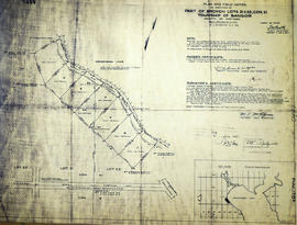
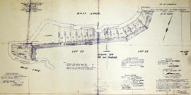
A certified reproduction of the "Subdivision of Block A, Lot # 1 and Lot # 72, Reg'd Plan No. 982...First and Broken Front Concessions, Township of Sidney, now City of Belleville, Plan prepared for Maurice Rollins Construction Ltd.” The area includes; north from Dundas Street West, to Wright Avenue, being Lots # 1 to 34 along Applewood Drive and Wright Avenue. Surveyed by Walter I. Watson, O. L. S. and signed March 23, 1961.

Donated by Walter I. Watson, P. L. S.

Sans titre

Subdivision of Applegrove Acres in the City of Belleville

  • CA ON00156 M/M440-2327
  • Pièce
  • 11 Apr 1962
  • Fait partie de Map collection

A certified reproduction of the "Applegrove Acres Subdivision - part of Lot # 10, Concession 1, formerly Township of Thurlow, now Belleville. Owner Charles W. Lambert.” The area includes; north Bridge Street East, with lots on Plaza Square & Bridge Street East. Surveyed by Thomas S. Ransom, O. L. S. and signed April 11, 1962.

Donated by Walter I. Watson, P. L. S.

Sans titre

Subdivision of Lesley Park in the City of Belleville

  • CA ON00156 M/M440-2328
  • Pièce
  • 25 May 1962
  • Fait partie de Map collection

A certified reproduction of the "Subdivision of part Lots # 10 and 11, Reg'd Plan No. 63, Township of Thurlow, now City of Belleville, owner Demille Construction Ltd.” The area includes; north of Victoria Avenue and west of Herchimer Avenue, Lots # 1 to 30 on Leslie Drive and Victoria Avenue. Surveyed by Thomas S. Ransom, O. L. S. and signed May 25, 1962.

Donated by Walter I. Watson, P. L. S.

Sans titre

Subdivision of part of Lot 29 in the Township of Bangor

  • CA ON00156 M/M430-2331
  • Pièce
  • 27 Mar 1963
  • Fait partie de Map collection

A certified reproduction of the "Subdivision of part of Lot # 29, Concession XI, Township of Bangor, for Dept. Lands & Forests.” The area includes; Lots # 1 to 6 and Block A on the east shore of Kamaniskeg Lake, being part of Lot # 29, Concession XI, Township of Bangor. Surveyed by M.J. McAlpine, O. L. S. and signed March 27, 1962.

Donated by Walter I. Watson, P. L. S.

Sans titre

Rodgers Subdivision in the Village of Stirling

  • CA ON00156 M/M430-2332
  • Pièce
  • 1 Jun 1962
  • Fait partie de Map collection

A certified reproduction of the "Subdivision of part of the North half of Lot # 24, Concession IX, Township of Sidney, now in [the] village of Stirling.” The area includes; Lots # 1 to 21 and Blocks A, B, C on Rogers Drive and Elizabeth Street being north half Lot # 24, Concession IX, Township of Sidney. Surveyed by Thomas S. Ransom, P. L. S. and signed June 1, 1962.

Donated by Walter I. Watson, P. L. S.

Sans titre

Subdivision of Vermilyea Heights in the Township of Thurlow

  • CA ON00156 M/M430-2334
  • Pièce
  • 8 Feb 1963
  • Fait partie de Map collection

A certified reproduction of the "Vermilyea Heights Subdivision of part of Lot # 1 Concession IV, Township of Thurlow, owner Clarence W. & Gladys Vermilyea.” The area includes; east of Sidney Street, Lots # 1 to 11 and Block A on Pleasantview Crescent and Sunning Dale Drive, between Concession III & IV, Thurlow Township. Surveyed by Walter I. Ransom, O. L. S. and signed February 8, 1963.

Donated by Walter I. Watson, P. L. S.

Sans titre

Eastview Heights Subdivision in the City of Belleville

  • CA ON00156 M/M440-2337
  • Pièce
  • 17 May 1963
  • Fait partie de Map collection

A certified reproduction of the "Subdivision Eastview Heights, part of Lot # 13, Concession 1, Township of Thurlow now City of Belleville.” The area includes; north of Victoria Avenue being Lots # 1 to 25, Blocks A-B laid out on Edge Hill Road, Kingsway Court, Victoria Avenue, and Haig Road. Surveyed by Thomas S. Ransom, O. L. S. and signed May 17, 1963.

Donated by Walter I. Watson, P. L. S.

Sans titre

Subdivision of Greenfield Park in the Township of Thurlow

  • CA ON00156 M/M430-2343
  • Pièce
  • 30 Sep 1963
  • Fait partie de Map collection

A certified reproduction of the "Subdivision [of] “Greenfield Park”- part of Lots # 3 & 4, Concession IV, Township of Thurlow.” The area includes; Lots on Ross Crescent along the Moira River south of River Road. Surveyed by Ronald Benn, O. L. S. and signed September 30, 1963.

Donated by Walter I. Watson, P. L. S.

Sans titre

Subdivision of part of Lots 15-16 in the City of Belleville

  • CA ON00156 M/M440-2345
  • Pièce
  • 29 Jan 1964
  • Fait partie de Map collection

A certified reproduction of the "Subdivision of part of Lots # 15 and 16, Reg'd Plan No. 769, formerly Township of Thurlow, now City of Belleville.” The area includes; Lots # 1, 2, 3, south of Auburn Street, between Shamrock Street [Road], Glendale Road and north from College Street West. Surveyed by Ronald Benn, O. L. S. and signed January 29, 1964.

Donated by Walter I. Watson, P. L. S.

Sans titre

Subdivision of part of Lots 6-7 in the City of Belleville

  • CA ON00156 M/M440-2346
  • Pièce
  • 20 Feb 1964
  • Fait partie de Map collection

A certified reproduction of the "Subdivision of Lots # 6 & 7 Reg'd Plan No. 1048, owners- Maurice H. Rollins Construction Ltd.” The area includes; Lots 2-3, south of Parkdale Drive and west of Shamrock Street being east of Sidney Street. Surveyed by Thomas S. Ransom, O. L. S. and signed February 20, 1964.

Donated by Walter I. Watson, P. L. S.

Sans titre

Subdivision of part of Lot 22 in the City of Belleville

  • CA ON00156 M/M440-2347
  • Pièce
  • 1 Jun 1964
  • Fait partie de Map collection

A certified reproduction of the "Subdivision of part of Lot # 22, Reg'd Plan No. 797, City of Belleville, owner- West Park Construction Belleville Ltd.” The area includes; Lots 1 to 3 west of Lemoine Street and north of Auburn Street. Surveyed by Thomas S. Ransom, O. L. S. and signed June 1, 1964.

Donated by Walter I. Watson, P. L. S.

Sans titre

Glenarden Subdivision in the City of Belleville

  • CA ON00156 M/M440-2348
  • Pièce
  • 17 Jun 1964
  • Fait partie de Map collection

A certified reproduction of the "Glenarden Subdivision- part of Lot # 37, Concession 2, Township of Sidney, now in City of Belleville- owner A L M O Developments Ltd.” The area includes; north of C.N. Railway, north to both sides of College Street West. Lots # 1 to 65 and Blocks A, B, C on Progress Avenue, Glenarden Crescent, Westmount Drive, Walden Circle, College Street West and Thorncliffe Drive. Surveyed by Thomas S. Ransom, O. L. S. and signed June 17, 1964.

Donated by Walter I. Watson, P. L. S.

Sans titre

Topographical Map of Tweed - Canada sheet

A topographical map of Tweed - Canada sheet #31 C/6 (east half). Area extends from west Blessington to east of the Salmon River and north to Bogart and south to Lonsdale. Map was published by the Department of National Defence in 1950. Scale 1:50,000.

Sans titre

Highlands of Hastings, Trenton and Belleville Maps

  • CA ON00156 M/M440-3058
  • Pièce
  • 1966-1967
  • Fait partie de Map collection

A map entitled "Highlands of Hastings, Trenton and Belleville," published by the Canada Map Service in honour of Canada's Centennial. Area includes Trenton and Belleville on the front and on the backside west Frankford, east to Hungerford, north to Lake St. Peter and south to the Bay of Quinte. Dated 1966-1967.

Sans titre

Re-survey of Lake and Marmora Township boundaries

  • CA ON00156 M/M430-2312
  • Pièce
  • 29 Feb 1960
  • Fait partie de Map collection

A certified reproduction of the "Re-survey of boundaries between Township of Lake and Marmora, from Concession 4 to Concession 10; also Road allowances between Concession 5 & 6 in front of Lots # 1 to 5 in [the] Township of Lake.” Surveyed by John G. Pierce of Pierce & Pierce, O. L. S., and signed February 29, 1960.

Donated by Walter I. Watson, P. L. S.

Sans titre

Subdivision of Lots 11-12 in the Township of Huntingdon

  • CA ON00156 M/M430-2315
  • Pièce
  • 10 Nov 1960
  • Fait partie de Map collection

A certified reproduction of the "Subdivision of part Lots # 11 & 12, Concession 13, Township of Huntingdon.” The area includes; Moira Lake, old County Road Hwy 62 and proposed new bridge. Surveyed by John Thomas Ransom, O. L. S. and signed November 10, 1960.

Donated by Walter I. Watson, P. L. S.

Sans titre

Subdivision of part of Broken Lots 21-22 in the Township of Bangor

  • CA ON00156 M/M430-2320
  • Pièce
  • 16 Mar 1960
  • Fait partie de Map collection

A certified reproduction of the "Subdivision of part of Broken Lots # 21 & 22, Concession XI, Township of Bangor.” The area includes; Lots # 1 to 7, Lots # 3A, 4A, 5A, on the northeast shore of Kaminiskeg Lake, being Lots # 21 & 22, Concession XI, Township of Bangor. Surveyed by Michael J. McAlpine, O. L. S. and signed March 16, 1960.

Donated by Walter I. Watson, P. L. S.

Sans titre

Plan to amend part of Lot # 13 in the Township of Sidney

  • CA ON00156 M/M430-2234
  • Pièce
  • 17 Feb 1956
  • Fait partie de Map collection

A certified reproduction of the "Plan to amend subdivision Plan No. 988 of part of Lot # 13, Concession 1, Sidney Township.” The area includes; part Lot # 13, Concession 1, east of Road Allowance between Lots # 12 & 13 (White's Road), being 22 Lots on both sides of Quinte Street. Surveyed by W.J. Pattison, O. L. S. and signed February 17, 1956.

Donated by Walter I. Watson, P. L. S.

Sans titre

Subdivision of part of Lots 8-9, 16 in the Township of Thurlow

  • CA ON00156 M/M440-2248
  • Pièce
  • 31 Mar 1956
  • Fait partie de Map collection

A certified reproduction of the "Subdivision of part Lots # 8, 9, & 16, Reg'd Plan 217. Township of Thurlow.” The area includes; north of Victoria Avenue and east of Farley Avenue, being Lots laid out on Lambert Drive and Linton Park Road. Surveyed by John T. Ransom, O. L. S. and signed March 31, 1956.

Donated by Walter I. Watson, P. L. S.

Sans titre

Subdivision of Lots 22-23 in the Township of Tudor

  • CA ON00156 M/M430-2291
  • Pièce
  • 9 Aug 1957
  • Fait partie de Map collection

A certified reproduction of the "Subdivision of part Lots # 22 & 23, Concession XIX, Township of Tudor, for Herbert Moore.” The area includes; shore property between Bass Lake and Moore's Road being Lots # 30 to 46, inclusive, beginning at Concession Road between Townships of Tudor & Limerick. Surveyed by John Thomas Ransom, O. L. S. and signed August 9, 1957.

Donated by Walter I. Watson, P. L. S.

Sans titre

Résultats 4961 à 4980 sur 5602