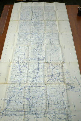
Land, settlement and immigration

Taxonomy

Code

Scope note(s)

Source note(s)

Display note(s)

Hierarchical terms

Land, settlement and immigration

Equivalent terms

Land, settlement and immigration

Associated terms

Land, settlement and immigration

1531 Archival description results for Land, settlement and immigration

1531 results directly related Exclude narrower terms

Plan of Diseronca (Deseronto)

1972 copy of an 1837 plan of 'Diseronca' (now Deseronto, Ontario), surveyed by G.J. Clapp on August 26th, 1837. The plan is Plan 43 of the plans registered in the Hastings County Registry.

The north-south streets shown on the right side of the map are, from right to left, First Street, Second Street, Third Street and Fourth Street. Near the end of Fourth Street a wharf is marked on the map. This is Culbertson's Wharf.

Clapp, Gilbert S. P.L.S.

Aerial Photograph of Hamilton and Hope Townships

  • CA ON00156 M/M470-2781 - 2794/2789
  • Item
  • 27 Aug 1973
  • Part of Map collection

Hamilton & Hope Townships, Map (order) 841-5711 showing areas of; Hamilton & Hope Townships-including Cobourg & Port Hope showing Hydro lines and gas & oil pipelines. Dated August 27, 1973. Scale: 1 inch = 2000 feet.

Madoc Township : history of Bannockburn

File contains original and photocopied manuscript histories of the settlement and early development of Bannockburn including the lumbering and sawmilling industries. Includes a printout of a webpage on Maitland House (available on the Internet Archive's Wayback Machine at https://web.archive.org/web/20010805101431/http://casa-de.vrx.net/buildings/) and an article from the Fall 2019 Country Roads magazine about the conversion of St. Bartholomew Anglican Church in Bannockburn into a private home.

Crown sale grant of land in Marmora Township

  • 2022-039
  • Item
  • 1867

Province of Canada sale of Crown Lands (lot 15 in the fifth concession of Marmora Township) to John Fidlar, yeoman, of Marmora Township for $300.

Government of Canada

Tyendinaga - Mohawk Reserve

File contains a souvenir booklet published by the 1960-1961 Council of Tyendinaga Indian Reserve, Deseronto, that contains stories and photos of the local Mohawk people. The file also contains a brief history entitled "Mohawks of Tyendinaga Reserve" written by Susan Claus, as well as a copy of Gerry Boyce's chapter on the "Tyendinaga Reserve" from Historic Hastings, annotated by Leslie Claus.

Zwick's Island

The file contains a newspaper article from the Ontario Intelligencer. It is a letter to the Editor from T.G. Wrightmeyer about the proposition by the then Mayor Haig to change the name of Zwick's Island. The article gives the history of this parcel of land dating back to 1790 given to Captain Phillip Zwick and subsequent generations.

Rawdon Township : diary of W. Hambly, 1793-1794

File contains a reproduction of a manuscript diary of W. Hambly, surveyor, for the period 6 December 1793 to 1 May 1794. The diary entries discuss the survey process in Thurlow, Sidney, Huntingdon and Rawdon Townships. Also present is a typescript transcript of the diary with an appended footnote section which contains a glossary of terms.

Reproduction of a map of Upper Canada

  • CA ON00156 M/M400-1000
  • Item
  • Mar. 1792 - Sept. 1795
  • Part of Map collection

Reproduction of a map showing "the Routes Lt. Gov. J. G. Simcoe took on trips" throughout Upper Canada from March 1792 to September 1795. The map was charted by Lt. Gov. Simcoe. A good depiction of the area now referred to as Southern Ontario and his plans for a capital there - "London." This map was published as part of "Charting Our Past" from the Archives of Ontario by Stonehouse Publications.

Scale: about 20 miles to an inch.

Zoning Map of Belleville 1974

A map showing a zoning limits street plan within the City of Belleville. The zones and symbols can be referenced on the legend. The map was published on February 6, 1974.

Herschel Township, 1858-1864

File contains a copy of manuscript fieldnotes on a survey of Herschel Township performed by A.B. Perry, Provincial Land Surveyor, in 1864. Also contains a copy of a manuscript report, diary and fieldnotes on Herschel Township, 1858 by J.S. Peterson, Provincial Land Surveyor.

Perry, A.B.

Map of Belleville by Evans & Bolger 1877

An 1877 map of Belleville, Hastings County, Ontario by Evans & Bolger, surveyors. Map includes a table showing dates of plans in the registry office with plan name, wards and dates.

Faraday Township: report of field notes, 1857-1867

File contains photocopied manuscript field notes by Quintin Johnston, Provincial Land Surveyor concerning resources and quality of land in Faraday Township in 1857. Also contains photocopied manuscript field notes concerning road and land surveys in Faraday Township as surveyed by Forneri and Kennedy, 1869-1870. Undated,[ ca. 1960s?] original manuscript notes containing excerpts of the aforementioned surveys are also present.

Results 1 to 20 of 1531