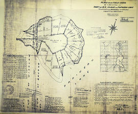
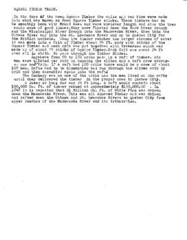
Natural resources

Taxonomy

Code

Scope note(s)

Source note(s)

Display note(s)

Hierarchical terms

Natural resources

Equivalent terms

Natural resources

Associated terms

Natural resources

139 Archival description results for Natural resources

139 results directly related Exclude narrower terms

Correspondence of John Brett McGeachie and copy of 'Bass Lake' book

  • CA ON00156 2021-099
  • Collection
  • 1994-2003

Copy of McGeachie's book Bass Lake - Hastings County and correspondence between McGeachie and various authorities about the management of the McGeachie Conservation Area and his efforts to change the name of Steenburg Lake in Limerick Township, Hastings County, Ontario.

McGeachie, John Brett 'Jack'

Map by the Bancroft Mineral Society

A map of the highways, gravel roads, towns and mineral deposits located in the town of Bancroft and the surrounding area. Published by the Bancroft and District Chamber of Commerce. On the reverse side is the key to the numbered mineral deposits - types of minerals and the exact location/owner.

Bancroft and District Chamber of Commerce

Geological Map of the Madoc and Gananoque areas

2 maps showing geological areas in Madoc (Map No. 2053) and Gananoque (Map No. 2053). Scale 1 in to 2 miles. Booklet by D. F. Hewitt, Senior Geologist, Ontario Department of Mines, Toronto.

Ontario. Ministry of Natural Resources and Forestry

Subdivision of part of Big Island on Papineau Lake

A certified reproduction of the "Subdivision of part of Big Island in Papineau Lake, Township of Bangor & Wicklow - for Dept. Lands & Forests.” The area includes; Big Island in Papineau Lake, Lots # 1-8 and Blocks P-I in the Township of Bangor & Wicklow. Surveyed by John Thomas Ransom, O. L. S. and signed December 1, 1960.

Donated by Walter I. Watson, P. L. S.

Ransom, John Thomas, P.L.S.

Subdivision of part of Lot 3 in the Township of Wicklow

A certified reproduction of the "Subdivision of part of Lot # 3, Concession 10, Township of Wicklow, prepared for Dept. of Lands & Forests.” The area includes; Lots # 1 to 12, Blocks A to D on the northwest shore of Papineau Lake. Surveyed by Michael J. McAlpine, O. L. S. and signed December 1, 1960.

Donated by Walter I. Watson, P. L. S.

McAlpine, Michael Joseph, O.L.S.

Subdivision of Lot 1 in the Township of Wicklow

A certified reproduction of the "Subdivision of Lot # 1, Concession 10 & 11, Township of Wicklow, for Dept. Lands & Forests.” The area includes; Lots # 1 to 5 and Block 'A' on the northeast shore of Papineau Lake in Wicklow Township. Surveyed by Michael J. McAlpine, O. L. S. and signed December 1, 1960.

Donated by Walter I. Watson, P. L. S.

McAlpine, Michael Joseph, O.L.S.

Map of Mineral Deposits in Marmora

An original, coloured plan of mineral deposits in "Marmora - Scale half mile to an inch." The plan includes Lots 1-20 on Concessions 6-11 in Marmora Township.

The types of mineral deposits include ranges of silurian limestone, metamorphic rocks, a gold bearing belt, and a range of reddish syenites. Mining companies include Hawkeye Co. Mine, Gatling Mining Co., Taule Mine, Severn Mine, McKinnon Mine and the Canada Consolidated Gold Mining Company. Also featured is the settlement of Malone, several roads, lakes and the Central Ontario Railway.

Plan of Gatling Co.'s Gold Mining Property and adjoining lots in Marmora

"Plan of Gatling Co.'s Gold Mining Property and adjoining lots, Marmora, County of Hastings, Ontario." Scale: 1:3000. Published by The Desbarats Lith. and Comp. Montreal.

Donated by the Col. W. N. Ponton Estate. Col. Ponton or a relation presumably made the additional pen-written notes on the map.

Gatling Company owned the Gatling and Tuttle shafts at the Delora Mine, which were first opened by the Gatling Gold and Silver Mining company in 1873.
Read more: http://www.marmorahistory.ca/1866-founding-of-deloro

Desbarats Lithography and Company

Geological Maps of Hastings and surrounding counties

  • CA ON00156 M/M460-1534 - 1554
  • Series
  • 1975-1984
  • Part of Map collection

Various maps of the Precambrian, Quarternary, and Paleozoic geology in Northumberland, Frontenac, Hastings, Lennox and Addington counties.

Ontario. Ministry of Natural Resources and Forestry

Results 1 to 20 of 139