- CA ON00156 2014-49/31
- Unidad documental compuesta
- 1910-1932
Parte deSmith family photographs
Black and white photographs of varying size. Photos taken in Ottawa, Ontario. Place names are written on the photos.
201 resultados directamente relacionados Excluir términos relacionados
Parte deSmith family photographs
Black and white photographs of varying size. Photos taken in Ottawa, Ontario. Place names are written on the photos.
Parte deSmith family photographs
Black and white photographs of varying size. Photos taken throughout Ontario, Canada. Place names are written on the photos. Napanee, Gananoque, St. Ann, North Bay, Welland Canal, Massey, Point Traverse, Sault Ste. Marie
Parte deSmith family photographs
Black and white photographs of varying size. Photos taken at different locations throughout Quebec. Montreal, Gaspe and Quebec City. Place names are written on each photograph.

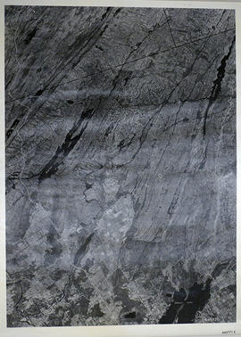
Parte deMap collection
A reproduction of an air survey photograph produced by the Ontario Ministry of Natural Resources. Map # 444773E of Rawdon Township in Hastings County, Ontario. Circa 1950.
The photograph shows Rawdon Township from the eastern border to Hwy 14, Harold and Springbrook Villages, western Huntingdon Township, southern Marmora and Madoc Townships, Banker Lake.
Donated by Walter I. Watson, P.L.S.
Sin título

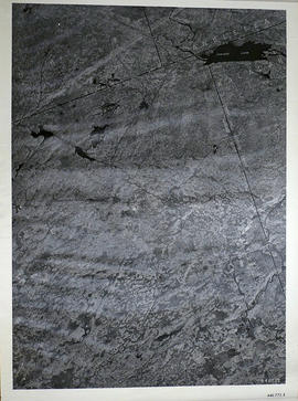
Parte deMap collection
A reproduction of an air survey photograph produced by the Ontario Ministry of Natural Resources. Map # 444773W of Rawdon Township in Hastings County, Ontario. Circa 1950.
The photograph shows Rawdon Township, Concession 8 to 14, west of Hwy 14, small sections of Marmora Township including Marmora Village and Crow Lake and a small part of Seymour Township in Northumberland County
Donated by Walter I. Watson, P.L.S.
Sin título
Sheffield Township Map # 445771E
Parte deMap collection
A reproduction of an air survey photograph produced by the Ontario Ministry of Natural Resources. Map #445771E of Sheffield Township in Lennox and Addington County, Ontario. Circa 1950.
The photograph shows Sheffield Township, Concession 3 to 9, Beaver Lake and north to Kaladar Township, Concession VIII to XI, Lingham Lakes in Grimthorpe Township in Hastings County.
Donated by Walter I. Watson, P.L.S.
Sin título
Elzevir Township Map # 446772E
Parte deMap collection
A reproduction of an air survey photograph produced by the Ontario Ministry of Natural Resources. Map #446772E of Elzevir Township in Hastings County, Ontario. Circa 1950.
The photograph shows the North East part of Elzevir Township, Elzevir Creek and the Skootamata River.
Donated by Walter I. Watson, P.L.S.
Sin título

Field Notes of the Township of Faraday
Photocopied cover of manuscript field notes by Quintin Johnston, Provincial Land Surveyor concerning resources and quality of land in Faraday Township in 1857. Published by Ontario Department of Crown Lands.
Sin título
South African [Boer] War : map, 1899
File contains a printed, coloured map of the South African Republic, Orange Free State and Cape Colony as they appeared in 1899.
File contains a one-page typescript history of the watershed of the Moira River and an account of the naming of the river in honour of the Earl of Moira in Ireland.
Peace River Valley / by Harry M. Moore
File contains three newspaper articles by Harry M. Moore which appeared in the December 12th and December 19th, 1959 and January 2nd, 1960 editions of the Ontario Intelligencer. The articles chronicle Moore's travels along the Alaska Highway and into the Peace River Valley as well as areas in Northern Alberta.

Map of the Moira Region Watershed
Parte deMap collection
A map of the Moira Region Watershed. Polychrome colours symbolize the varieties of soils and land use surveys, see Legend. Not dated, circa 1950. Published by the Ontario Department of Planning and Development, Conservation Branch. Dimensions 58.5cmx 69cm.
Sin título

South and Central Hastings Map
Parte deMap collection
"Cummins Rural Directory Map:" A map of South and Central Hastings, in 1923, featuring post offices, hamlets and lot owners. Map is surrounded by advertisements. Published by Cummins Map Co., Toronto. Dimensions 71cm x 50.5cm.
Sin título

Geological Map of Madoc Gold Region
Parte deMap collection
A Geological Map of the Madoc Gold Region, 1866. Geological data on map was taken principally from the reports of the Geological Survey of Canada. Secondly, by information and facts obtained on the spot by gentlemen engaged in the gold fields. What follows is a description of the general geological character of the area.
Author: Henry White, P.L.S. Published by G. B. Ware, 16 Toronto Street, Toronto, Ontario.
Sin título

Map of Railway Station, Harbour and Wharf Facilities
Parte deMap collection
A map detailing the Grand Trunk Railway's station (1882), harbour and wharf facilities (1878) in Belleville, Ontario. Legends on each side of the maps describe buildings and areas. By William Michaud.
Sin título

Belleville and Bay of Quinte depth chart
Parte deMap collection
Reproduction made in 1976 of an 1875 map of the Belleville Harbour in Bay of Quinte. The map features major streets, buildings and depth readings of travelled waters. Surveyed by F. M. Hamel, C.E. Drawn by J. M. Faga. Scale: 1:6000.
Sin título
Teacher's Guide to Quinte in 1785
Parte deMap collection
Map showing the Bay of Quinte to Presqu'ile to the eastern tip of Grande Isle (Wolfe Island) used as a teacher's guide to the area in 1785. The 20th century names are in capital letters as per the Legend.
Parte deMap collection
Map showing Upper Canada settlements in 1835. From the Archives of Canada.
Map of Essex County (Southwestern Ontario)
Parte deMap collection
A map showing Essex County in southwestern Ontario, 1887. It features information and reference to railways at the time. Published and donated by S.R.G. Penson.
Received from the Archives of Canada's map collection - 27 Jul. 1966.
Sin título
Counties from Belleville to Ottawa
Parte deMap collection
A map showing counties from Belleville to Ottawa, Ontario, 1887. Published and donated by S.R.G. Penson.
Received from the Archives of Canada's map collection - 27 Jul. 1966.
Sin título