Transportation and utilities

Taxonomy

Code

Scope note(s)

Source note(s)

Display note(s)

Hierarchical terms

Transportation and utilities

Equivalent terms

Transportation and utilities

Associated terms

Transportation and utilities

208 Archival description results for Transportation and utilities

208 results directly related Exclude narrower terms

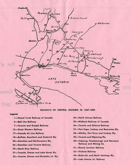
Map of Central Ontario Railways in 1847-1889

A map detailing the railways during 1847-1889 in Central Ontario. The legend assigns a number to the name of each railway. Composed and published by William Michaud of Shannonville, Ontario.

Michaud, William

Grand Trunk Railroad from Belleville to Point Ann

Map showing Grand Trunk railway extending from Belleville to Point Ann in Hastings County. Also shows different lots, with named proprietors and number of acres. Dated June 10, 1904. Scale: 1" : 400ft. Surveyed by R. Aylsworth, Ontario Land Surveyor.

Map copied from the Archives of Ontario.

Aylsworth, William Robert, O. L. S.

Map of Belleville to Point Ann train tracks

Map showing CPR railway extending from Belleville to Point Ann in Hastings County. Dated June 15, 1903. Scale: 1" : 400ft. Surveyed by R. Aylsworth, Ontario Land Surveyor.

Map copied from the Archives of Ontario.

Aylsworth, William Robert, O. L. S.

Map of Hastings County and surrounding area

A map of Hastings County as of February 1978. Published by Surveyors and Plans Office, Cartography section. Produced by the Ministry of Transportation and Communications. Map features information regarding roads, settlements, boundaries, parks and transportation. Scale: 1:250,000.

Ontario. Ministry of Transportation

Townships of Hastings County with advertisements

A map of Hastings County, in 1932, showing lakes, rivers, cities, towns and townships. A list of businesses within the county are on the right. Drawn exclusively for and published by Croydon Publishing Company.

Croydon Publishing Co.

Map of Essex County (Southwestern Ontario)

A map showing Essex County in southwestern Ontario, 1887. It features information and reference to railways at the time. Published and donated by S.R.G. Penson.
Received from the Archives of Canada's map collection - 27 Jul. 1966.

Penson, S. R. G.

Counties from Belleville to Ottawa

A map showing counties from Belleville to Ottawa, Ontario, 1887. Published and donated by S.R.G. Penson.
Received from the Archives of Canada's map collection - 27 Jul. 1966.

Penson, S. R. G.

Map of the Trent Canal

A map of the Trent Canal in Ontario, September 1st, 1918. Published by the Department of Railways and Canals, Canada. Scale: 1" = 400 feet.

Canada. Department of Railways and Canals

Results 201 to 208 of 208