- CA ON00156 2010-41
- Item
- c.1980
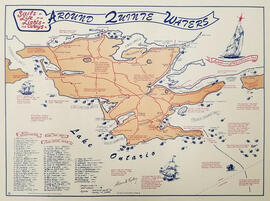
Map showing the location, names and dates of shipwrecks around the shoreline of Prince Edward County.
Ralley, Allan A.
20 results directly related Exclude narrower terms
Map showing the location, names and dates of shipwrecks around the shoreline of Prince Edward County.
Ralley, Allan A.
Lake Ontario & Bay of Quinte Steamboat Company
The file contains two copies of postcards from The Lake Ontario & Bay of Quinte Steamboat Company, Kingston, dated 10 August 1897 and 1902, addressed to Mr. George Waggett, Picton, Ontario.
The file contains a commemorative pamphlet on the history of the Weller's Stage Coach, along with a copy of an advertisement from the Cobourg Star (11 August 1841).
This file contains: 1) A photocopied typed article titled "Telegraph Island Light", about the lighthouse erected 1870 in the Bay of Quinte; 2) A timetable for the steamer Varuna, circa 1920, Captain A. Hicks; 3) A photocopy of the obituary for Rev. James Rollins born 28 October 1865 in Madoc and died 7 February 1943 in Kingston.

Plans for COR Station at Picton
Part of Map collection
A blueprint of the proposed new COR station at Picton, Prince Edward County, Ontario. Drawn by John Dunlop Evans, Chief Engineer. Published by the Office of Master of Bridges and Buildings G.T.R. in December 1901.
Evans, John Dunlop, P.L.S.

Plans for COR Station at Picton
Part of Map collection
A blueprint of the proposed new COR station at Picton, Prince Edward County, Ontario. Drawn by John Dunlop Evans, Chief Engineer. Published by the Office of Master of Bridges and Buildings G.T.R. in December 1901.
Evans, John Dunlop, P.L.S.

Plans for COR Station at Wellington
Part of Map collection
A blueprint of the proposed new COR station at Wellington, Prince Edward County, Ontario. Drawn by John Dunlop Evans, Chief Engineer. Published by the Office of Master of Bridges and Buildings G.T.R. on March 23, 1911.
Evans, John Dunlop, P.L.S.

COR Station at Bloomfield Plans
Part of Map collection
A blueprint planning the COR passenger station at Bloomfield, Hastings County, Ontario. Plan features floor, platform plans, elevation and sections. Drawn by John Dunlop Evans, Chief Surveyor/Engineer - July 24, 1909.
Evans, John Dunlop, P.L.S.
Map of Prince Edward County c.1975
Part of Map collection
Prince Edward County Map, circa 1975. Published by the Ministry of Transportation and Communications. Composed by Hon. James Snow (Minister) and Harold Gilbert (Deputy Minister).
Features: road jurisdictions, Kings Highways, secondary highways, county roads, township roads, roads legally open but not necessarily passable, urban corporate limits, railways and stations, township boundaries, county boundaries, populated areas.
Donated by the Belleville Public Library in 2014.
Ontario. Ministry of Transportation
Map of Prince Edward County 2001
Part of Map collection
Prince Edward County with Quinte's Isle in 2001. Published by the Prince Edward County Chamber of Tourism & Commerce.
Features: Map of Picton with West Lake & East Lake. Map Bloomfield & Wellington.
Donated by the Belleville Public Library in 2014.
Prince Edward County Chamber of Tourism and Commerce
Map of Lennox and Addington, Frontenac and Prince Edward Counties.
Part of Map collection
A map of Lennox and Addington, Frontenac and Prince Edward Counties as of April 1st, 1974. Published by Engineering Plans Office, Cartography section. Produced by the Ministry of Transportation and Communications. Map features information regarding roads, settlements, boundaries, parks and transportation. Scale: 1:250,000. Dimensions: 71cm x 56cm.
Ontario. Ministry of Transportation
Map of Prince Edward County 1972
Part of Map collection
Prince Edward County as of April 1972. Published by the Ministry of Transportation and Communications.
Features: road jurisdictions, Kings Highways, secondary highways, county roads, township roads, roads legally open but not necessarily passable, urban corporate limits, railways and stations, township boundaries, county boundaries, populated areas.
Donated by the Belleville Public Library in 2014.
Ontario. Ministry of Transportation
Aerial Photograph of Sophiasburgh Township
Part of Map collection
An aerial photograph of Sophiasburgh Township, Map # 1.71-4402- 2-144, (small section). The total area covered includes, Hwy 62 along the east side, Smith Road on west side, and in the centre Concession 7. A Provincial Government Aerial Photo. Dated 1971.
Aerial Photograph of Sophiasburgh Township
Part of Map collection
An aerial photograph of Sophiasburgh Township, Map # 1.71-4402- 2-144 (enlarged section). The total area covered includes, Consecon Creek and Marsh, Hwy 62, County Road 2 and west Concession 7 in centre of map. A “Little Swamp”, Provincial Government Aerial Photo. Scale 1:10,000. Dated 1971.
Aerial Photograph of Sophiasburgh Township
Part of Map collection
An aerial photograph of Sophiasburgh Township, Map # 1.71-4402- 2-144. The total area covered includes, Consecon Creek and Marsh, Hwy 62, County Road 2 and west Concession 7 in centre of map. A “Little Swamp”, Provincial Government Aerial Photo. Scale 1:10,000. Dated 1971.

Plans for COR Station at Hillier
Part of Map collection
A blueprint of the proposed new COR station at Hillier, Prince Edward County, Ontario. Drawn by John Dunlop Evans, Chief Engineer. Published by the Office of Master of Bridges and Buildings G.T.R. on February 18, 1911.
Evans, John Dunlop, P.L.S.

Article on building of Skyway Bridge
Newspaper clipping (possibly from the Intelligencer newspaper of Belleville) with a photograph of the construction of the piers of the new Skyway Bridge at Green Point in Prince Edward County, Ontario.
Railways - Prince Edward County Railway
The file contains an original letter dated 3-January-1881 at Picton, from G.W. McMullen, Vice-President and General Manager of the Prince Edward County Railway, to W.R. Ponton.
Trenton : Ferry license, 1879; Bay of Quinte Navigation Company
File contains a manuscript license issued by the Province of Ontario on 13 October 1879 approving the operation of a ferry from Sidney Township in Hastings County to Ameliasburgh Township in Prince Edward County. Also present are two printed, completed bills of sale, dated 5 November 1880 transferring 64 shares in the steam paddler, Mary Ethel, built at Trenton, to the Bay of Quinte Navigation Company (Limited).
File contains an “Ontario Homes & Living” magazine story about Ontario's oldest road, the Danforth.