Madoc Township : history of schools
- CA ON00156 TR/1862
- File
- ca. 1963
File contains manuscript notes concerning the history of schools in Madoc Township from ca. 1845 to 1963.
133 results directly related Exclude narrower terms
Madoc Township : history of schools
File contains manuscript notes concerning the history of schools in Madoc Township from ca. 1845 to 1963.
Madoc Township : lodges and railroads
File contains photocopied manuscript notes on Orange Lodge branches and other social organizations including the Women's Institute and the Oddfellows in the period from 1885-ca. 1949. Also contains brief manuscript notes on railways in Madoc Township from ca. 1882-1964.
File contains a newspaper article on the history and development of talc mining in Madoc Township. Also contains photocopied printed notes from the Hastings County Directory, 1860-61 concerning Madoc Township and its resources with a list of landowners by concession and lot.

Part of Map collection
A reproduction of an air survey photograph produced by the Ontario Ministry of Natural Resources. Map #445772W of Madoc Township in Hastings County, Ontario. Circa 1950.
The photograph shows Madoc Township, Concession 5 to 9, Huntingdon Township Concession 14, northwest Elzevir Township, Queenboro and Black River.
Donated by Walter I. Watson, P.L.S.
Ontario. Ministry of Natural Resources and Forestry

Part of Map collection
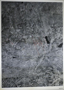
A reproduction of an air survey photograph produced by the Ontario Ministry of Natural Resources. Map #445773E of Madoc Township in Hastings County, Ontario. Circa 1950.
The photograph shows Madoc Township, Concession 1 to 7, Hwy 62, and Moira River Watershed, Eldorado, Lake Township, Concession 3 to 10.
Donated by Walter I. Watson, P.L.S.
Ontario. Ministry of Natural Resources and Forestry
Part of Map collection
A reproduction of an air survey photograph produced by the Ontario Ministry of Natural Resources. Map #446773E of Madoc Township in Hastings County, Ontario. Circa 1950.
The photograph shows the northern part of Madoc Township, Bannockburn, Tudor Township, Concession 1 to 9, Robinson Lake, Westerly to Millbridge, Moira River, Highway 62, and the Canadian National Railway.
Donated by Walter I. Watson, P.L.S.
Ontario. Ministry of Natural Resources and Forestry
Madoc, Elzevir, Tudor assessment 1858
1858 oath stating that there were upwards of five hundred people listed on the assessment roll for the united townships of Tudor, Elzevir and Madoc.
Map of Belleville to North of Bancroft
Part of Map collection
A map containing focused maps of: Trenton, Belleville, Prince Edward County, Frankford, Picton, Bancroft, Deseronto, Stirling, Tweed, Marmora and Madoc. Insets refer to roads, streets and highways. Published by Millhouse Maps in 2001.
MIllhouse Maps

Map of Hastings County in 4 sections
Part of Map collection
A map of Hastings County outlining townships from the Bay of Quinte in the south, to Wallaston, Limerick and Cashel in the north.
Map is in four sections. Scale: 3 miles : 1 inch. Original map is dated 1894. Photocopy from the Archives of Ontario.

Map of Hastings with the Principal Villages and the City of Belleville
Part of Map collection
A map of Hastings County including the Town of Belleville and other principal villages:
Trenton, Madoc, Marmora, Tweed, Bridgewater, Stirling, Wicklow, Bangor, Herschel, Monteagle, Carl, Dungannon, Wollaston, Limerick, Cashel, Tudor, Grimsthorpe, Elzevir; Rawdon, Huntingdon, Hungerford, Sidney, Thurlow, Tyendinaga.
Scale: 3 miles =1 inch. Published by Evans & Bolger, P. L. Surveyors, P.L.S. in 1879-1880.
Evans and Bolger

Map of Hastings with townships
Part of Map collection
A map of Hastings County outlining the twelve townships:
Marmora and Lake, Madoc, Tudor, Grimsthorpe, Elzevir; Rawdon, Huntingdon, Hungerford, Sidney, Thurlow, Tyendinaga.
As well as, the lots and concessions. Circa 1916.Scale: 4 miles: 1 inch.
Donated by K.G.M. Ross.
Map of Lots 1-19 in Madoc Township
Part of Map collection
A original plan of Lots 1 to 19 on Concessions 4 to 7 in Madoc Township, with proprietor names on Lots # 8 to 19 on Concessions 8 to 19. The plan is undated, however the proprietors match those of Belden's 1878 Atlas.
The village of Madoc is located at the south. On the left side is presumably part of a legend regarding land use.
Donated by the Glanmore National Historic Site in 2016.

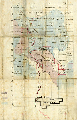
Part of Map collection
A map showing concessions and lots of Huntingdon - Madoc Township, Hastings County. Circa 1869. 30 advertisements for companies surround the map. Published by Macleod and Carre, Engineers and Surveyors. Scale: 1:63,000. Dimensions: 34.0cm x 37.0cm. Map was created from Government plan.
Donated from the Col. W. N. Ponton Estate. Penciled notes on map show Ponton family's interest in mining, especially after the Eldorado Gold Rush in 1866.
MacLeod and Carre, P.L.S.

Part of Map collection
A blueprint reproduction of a map of Madoc Township in Hastings County, Ontario. The map features the names of neighboring townships, lot and concession numbers, Central Ontario Railway, Moira River, a mill site and springs. Circa 1880. Scale 40 chains to an inch.

Map of the Counties of Hastings and Prince Edward
Part of Map collection
A "Map of the Counties of Hastings and Prince Edward." In 1898, the lots, concessions, churches, schools and mines are shown of the townships in Hastings and Prince Edward. Scale: 1.5 miles to an inch. Published by the Canadian Map Publishing Company in Hamilton, Ontario, for the Belleville Sun. Revised by Henry Carre, C.E. Inset is the map of North Hastings, scale 400 chains to an inch.
Carre, Henry, O.L.S.
Matthews, Todd "Donald McEwen" H. C. H. S. Student Essay Writing Contest
A biography essay on farmer, Baptist minister, and dog sled racer Donald McEwen written by 6th grader Todd Matthews for an essay contest in Madoc Township. Includes photographs. 12 pages.
McCaw, Joe Rupert's School Elzevir Twp. S.S. #7 H.C.H.S. Student Essay Contest
A report on the Rupert's School written by 6th grader Joe McCaw for the Madoc Township. Includes photographs and maps. 12 pages.
The file contains land records as follows:
McFee Papers : mining 1840-1889
File contains manuscript assignments of mortgages, indentures of sale and conveyance of mineral rights of the McFee Family of Belleville regarding properties in Madoc and Marmora Townships.
File contains completed printed mortgages, indentures of sale and deeds of John A McFee, Belleville for properties in the city of Belleville. Also present is a manuscript indenture of 21 March 1867 relating to a sale of land and mineral rights in Madoc Township from Samuel and Julia Bacon to George Dean Dickson.