Trenton, Ontario as colouring sheet
- CA ON00156 M/M440-1487
- Item
- 1990
Parte de Map collection
A "colour-in" map of Trenton, Ontario (now Quinte West) from 1990.
Sem título
179 resultados diretamente relacionados Excluir termos específicos
Trenton, Ontario as colouring sheet
Parte de Map collection
A "colour-in" map of Trenton, Ontario (now Quinte West) from 1990.
Sem título
Map of Belleville - The Friendly City
Parte de Map collection
A map of the Belleville featuring details about its history. Published by City Print International in 1991.
Sem título
Street Plan of the City of Belleville 1982
Parte de Map collection
A map showing street plans within the City of Belleville. The map was copyrighted 1982 and published by the Belleville Chamber of Commerce.
Sem título
Records of Stephens-Adamson plant in Belleville
Records created and accumulated by employees of the Stephens-Adamson manufacturing plant in Belleville, Ontario. Materials include printed catalogues, plans, an order book, photographs, and printed ephemera.
Sem título

Map of Town Plot at mouth of Trent River
Parte de Map collection
A map of a town plot at the mouth of the Trent River in the Newcastle District. The map features numbered lots, present streets and water ways. Scale: 1 inch = 2 chains. Originally surveyed by F. P. Rubidge, D.P.S., in 1834. This copy was issued September 23, 1926.
Sem título
Ontario Aerial photographs 1972-1977
Parte de Map collection
Aerial photographs showing various townships within Ontario in the 1970s.

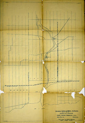
Trenton Electric & Water Co. Limited in Sidney Township
Parte de Map collection
An original map produced for the Trenton Electric & Water Co. Limited, concerning proposed transmission lines within the Township of Sidney. However, the map also features railways, roads and land boundaries. Circa 1910. Scale: 50 chains = 1 inch. Map composed by Smith, Kerry and Chace Engineers located in Toronto, Winnipeg, Calgary and Vancouver.
Donated by David Pershick.
Sem título

Seymour Power & Electric Co. Limited in Murray Township
Parte de Map collection
An original map produced for the Seymour Power & Electric Co. Limited, concerning proposed transmission lines within the Township of Murray. However, the map also features railways, roads, mills and land boundaries. Circa 1910. Scale: 50 chains = 1 inch. Map composed by Smith, Kerry and Chace Engineers located in Toronto, Winnipeg, Calgary and Vancouver.
Donated by David Pershick.
Sem título
Trenton Electric & Water Co. Limited in Thurlow and Sidney Townships
Parte de Map collection
An original map produced for the Trenton Electric & Water Co. Limited, concerning proposed transmission lines within the Townships of Thurlow and Sidney. However, the map also features railways, roads, mills and land boundaries. Dated March 31, 1910. Scale: 1/4 mile = 1 inch. Map composed by Smith, Kerry and Chace Engineers located in Toronto, Winnipeg, Calgary and Vancouver.
The map includes the first 4 concessions, Lots 33-38 in Sidney Township and Lots 1-13 in Thurlow Township.
Donated by David Pershick.
Sem título

Trenton Electric & Water Co. Limited in Thurlow Township
Parte de Map collection
An original map produced for the Trenton Electric & Water Co. Limited, concerning their water mains, towers and substations within the Township of Thurlow. However, the map also features railways, roads and land boundaries. Circa 1910. Scale: 50 chains = 1 inch. Map composed by Smith, Kerry and Chace Engineers located in Toronto, Winnipeg, Calgary and Vancouver.
Donated by David Pershick.
Sem título

Town of Trenton with advertising businesses
Parte de Map collection
A photocopy of a map of the Town of Trenton, circa 1915. The map features advertisements for local businesses, important sites, industries and many railways and stations.
Donated by Bruce Polmanter.
Survey of Bakelite Thermosets Ltd.
Parte de Map collection
A photocopy of a Tank and Tank Farm Survey pf the Bakelite Thermosets Ltd. Plant in Belleville, Ontario.

Negatives and photographs from Northern Electric plant in Belleville
Negatives and photographs of activities and buildings at the Northern Electric plant on Sidney Street in Belleville, Ontario. These items were contained in a metal Kardex filing drawer. Headings on the file sleeves include:
Sem título
Canada Map Index 1 from the National Topographic System
Parte de Map collection
A topographical map of Ontario from the Canada Index 1, Maps of the National Topographic System of Canada. Published by the Department of Mines and Resources (now the Department of Natural Resources). Dated July 1991. Scale 1:50,000.
Sem título
Ontario Base Map (Havelock to Belleville)
Parte de Map collection
A map of the Universal Transverse Mercator Grid System covering area in Zone 06 from Havelock to Brockville. Scale 1:250,000. Published by the Ministry of Natural Resources April 1st, 1989.
Sem título
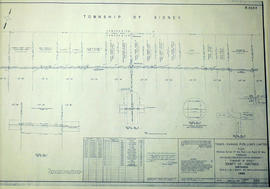
Sidney Township, Gas Line Map # RL32532
Parte de Map collection
"Sidney Township, Map # RL32532." A "Plan showing a survey of a Gas Pipe Line Right of Way though Lots # 20 to 29 inclusive, Concession 3, Township of Sidney, County of Hastings." Surveyed in 1958 by Marshall, Macklin & Monaghan, O. L. S Scale: 1 inch = 400 ft.
Donated by Walter I. Watson, P. L. S.
Sem título
Air Surveys of Hastings County, Ontario
Parte de Map collection
All air surveys were published in 1982. Scale 1; 10,000. By the Ontario Ministry of Natural Resources, Map base by Survey and Mapping Branch, Air Photography.
1) M470-2622. Rawdon Township Map # 10-18-2900-49050 showing areas of; the South West area of Rawdon Township, Concession 1 & 2 and Marsh Creek Watershed, Anson (Station) on the C. N. R. and part of Sidney Township, Concession 8.
2) M470-2623. Sidney Township, Map # 10-18-2900-49000 showing areas of; the Northwest area of Sidney Township being Trent River and Canal System including Wilson Island, Glen Ross, Richardson Cove, Heagles Island and South to Concession 6, Township of Sidney.
3) M470-2624. Sidney Township, Map # 10-18-2950-49000 showing areas of; Sidney Township, Concession 6, 7 and 8, Lots # 16 to 26, including part of Rawdon Creek, Oak Lake, Stirling Airfield..
4) M470-2625. Stirling, Map # 10-18-2950-4905 showing areas of; the Village of Stirling and surrounding area of Sidney & Rawdon Townships.
Sem título
Air Surveys of Belleville, Ontario
Parte de Map collection
All air surveys were completed in 1979 and published in 1982. Scale 1; 10,000. By the Ontario Ministry of Natural Resources, Map base by Survey and Mapping Branch, Air Photography.
1) M470-2690. Belleville, Sheet # 1, 10-18-3050-48900 showing areas of; Belleville and surrounding area, from the Bay of Quinte to near Hwy 401. The sheet includes both sides of Wallbridge Loyalist Road and both sides of the River Moira.
2) M470-2691. Belleville, Sheet # 2, 10-18-3050-48950 showing areas of; Belleville, Hwy 401, Cannifton, Corbyville, and Northerly along the Moira River to Concession 5.
3) M470-2692. Belleville, Sheet # 3, 10-18-3100-48900 showing areas of; East Belleville to both sides of Blessington Creek and Northerly from Bay of Quinte to CN Railway.
4) M470-2693. Belleville, Sheet # 4, 10-18-3100-48950 showing areas of; North section of Belleville, North of CNR and North of Hwy 401 including part of Concession 4. The Belleville Airfield is in the South East corner of the map.
Sem título
Air Surveys of Stirling, Ontario
Parte de Map collection
All air surveys were completed in 1984 and published in 1985. Scale 1 inch = 2000 feet. By the Ontario Ministry of Natural Resources, Map base by Survey and Mapping Branch, Air Photography.
1) M470-2683. Stirling, Sheet # 1, 02-18-2960-49060 showing areas of; the Village of Stirling, Sidney Township Lot # 20, Concession 9, with Rawdon Creek along the Westerly section of the map.
2) M470-2684. Stirling, Sheet # 2, 02-018-2950-49070 showing areas of; the Village of Stirling, Lots # 18, 19, 20 Concession 9 of Sidney Township and Lots # 14, 13, 12 Concession 1, Rawdon Township.
3) M470-2685. Stirling, Sheet # 3A, 02-18-2960-49070 showing areas of; the Village of Stirling, Lots # 21, 22, 23 Concession 9, Sidney Township, Lot # 12 Concession 1, Rawdon Township. Also, the Mill Pond of Rawdon Creek on Lot # 10 & 11, Concession 1, Rawdon Township.
4) M470-2686. Stirling, Sheet # 3B, 02-18-2960-49070 showing areas of; the Village of Stirling, Lots # 21, 22, 23 Concession 9, Sidney Township, Lot # 12 Concession 1, Rawdon Township. Also, the Mill Pond of Rawdon Creek on Lot # 10 & 11, Concession 1, Rawdon Township.
5) M470-2687. Stirling, Sheet # 4, 02-18-2970-49070 showing areas of; the Village of Stirling and Sidney Township.
6) M470-2688. Stirling, Sheet # 5, 02-18-2960-49080 showing areas of; the Village of Stirling and Rawdon Township; Lots # 12, 11, 10 Concession 1.
7) M470-2689. Stirling, Sheet # 6, 02-18-2970-49080 showing areas of; the Village of Stirling and Rawdon Creek.
Sem título
Parte de Map collection
A 33 participant directory and map of the 9th annual "Maple in the County" located in Prince Edward County. The event took place March 27-29 2010.
Sem título