Hungerford, Township of

Taxonomy

Code

Scope note(s)

Source note(s)

Display note(s)

Hierarchical terms

Hungerford, Township of

Hungerford, Township of

Equivalent terms

Hungerford, Township of

Associated terms

Hungerford, Township of

31 Archival description results for Hungerford, Township of

31 results directly related Exclude narrower terms

Duncan MacDonald papers

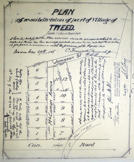
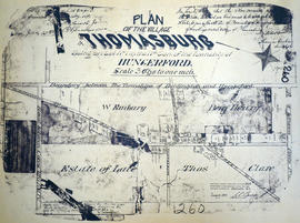
The file contains 30 documents: deeds, mortgages, insurance certificates and receipts. Names included in the documents are: D.M. Defoe, James Weir, William Vance, Samuel Vance, N.S. Apple, John Goodfellow, Philip Shannon, Joespeh Weir, Alex Roberts, Robert Arkles, Emery Arkles, William Climpson, Peter Merrills, C.J. Pope, J.S. McKeown, Hugh Erwin Weir, Angus Martin, Farley.

Land Records - Gardiner of Hungerford and Murney of Belleville

The file contains:

  1. an original copy of an indenture made in Whitby, County of York on 11 December 1829 between David Gardiner of Whitby and Thomas Goldsmith Gardiner, £50 received for 200 acres of land situated in the Township of Hungerford, Lot #17, First Concession; 2. an original copy of a Crown Sale Grant to Edmund Murney, of the town of Belleville, dated 23 December 1848 received £80 for 200 Acres in the Township of Elzevir, County Hastings, Lot #2, Second Concession.

Part of a deed for land in Hungerford Township

  • CA ON00156 2019-117
  • Item
  • 11 December 1829

Lower half of a memorial recording the sale of Lot 17 in Concession 1 of Hungerford Township from David Gardiner of to Thomas Goldsmith Gardiner, all of Whitby, for £50. The deed is instrument 1488 in Book L of the Hastings County Land Registry Office.

Hastings County Land Registry Office

Map of the Counties of Hastings and Prince Edward

A "Map of the Counties of Hastings and Prince Edward." In 1898, the lots, concessions, churches, schools and mines are shown of the townships in Hastings and Prince Edward. Scale: 1.5 miles to an inch. Published by the Canadian Map Publishing Company in Hamilton, Ontario, for the Belleville Sun. Revised by Henry Carre, C.E. Inset is the map of North Hastings, scale 400 chains to an inch.

Carre, Henry, O.L.S.

Map of Hastings with the Principal Villages and the City of Belleville

A map of Hastings County including the Town of Belleville and other principal villages:

Trenton, Madoc, Marmora, Tweed, Bridgewater, Stirling, Wicklow, Bangor, Herschel, Monteagle, Carl, Dungannon, Wollaston, Limerick, Cashel, Tudor, Grimsthorpe, Elzevir; Rawdon, Huntingdon, Hungerford, Sidney, Thurlow, Tyendinaga.

Scale: 3 miles =1 inch. Published by Evans & Bolger, P. L. Surveyors, P.L.S. in 1879-1880.

Evans and Bolger

Plan of Georgetown in the Township of Hungerford

A certified reproduction of the "Plan of Georgetown on part of Lot # 11 in 9th Concession of Hungerford Township for Felix Gabouri." On Stoco Lake, there are 66 unnamed lots. Surveyed by John Emerson, P.L.S. in November of 1849.

This copy was made in 1972 of plan #11, as registered in the Hastings Land Registry Office.

Donated by Walter I. Watson, O.L.S.

Emerson, John, P.L.S.

Plan of Lot 11 in the Village of Tweed

A certified reproduction of "Plan of re-subdivision of part of village of Tweed...Part of the southwest quarter of the south half of Lot # 11, Concession 10, Township of Hungerford. Laid out for John M. McCaman.” Surveyed by C. Fraser Aylsworth Jr., P.L.S., and signed May 29, 1886.

This copy was made in 1972 of plan #310, as registered in the Hastings Land Registry Office.

Donated by Walter I. Watson, P. L. S.

Aylsworth, Charles Fraser Jr., O.L.S.

Subdivision of Block 60 in the Village of Tweed

A certified reproduction of the "Subdivision of Block 60, Tweed, for proprietor James Quinn, witnessed by Stafford Quinn, clerk.” Surveyed by William R. Aylsworth, P.L.S., and signed August 17, 1900.

This copy was made in 1972 of plan #305, as registered in the Hastings Land Registry Office.

Donated by Walter I. Watson, P. L. S.

Aylsworth, William Robert, O. L. S.

Plan of Revision of Lot 10 in the Village of Tweed

A certified reproduction of the "Plan of Re-subdivision of part of Lot # 10, Concession 10, Hungerford Township, being in Tweed, for L. E. McPomeroy, owner.” Surveyed by C. Fraser Aylsworth Jr., P.L.S., and signed October 10, 1896.

This copy was made in 1972 of plan #297, as registered in the Hastings Land Registry Office.

Donated by Walter I. Watson, P. L. S.

Aylsworth, Charles Fraser Jr., O.L.S.

Plan of Re-subdivision of Lots 10-11 in the Village of Tweed

A certified reproduction of the "Plan of Resubdivision of Part of Lots # 10, 11, Concession 10, Hungerford Township, Adjoining Village of Tweed, for Dr. Timotheus E. Pomeroy.” Surveyed by C. Fraser Aylsworth Jr., P.L.S., and signed August 6, 1890.

This copy was made in 1972 of plan #294, as registered in the Hastings Land Registry Office.

Donated by Walter I. Watson, P. L. S.

Aylsworth, Charles Fraser Jr., O.L.S.

Plan of subdivision of Lot 11 in the Township of Hungerford

A certified reproduction of the "Plan of subdivision of part of the west half of the south half of Lot # 11, Concession 11, in Township of Hungerford for Thomas McCann, owner.” Surveyed by C. Fraser Aylsworth Jr., P.L.S., and signed July 13, 1892.

This copy was made in 1972 of plan #292, as registered in the Hastings Land Registry Office.

Donated by Walter I. Watson, P. L. S.

Aylsworth, Charles Fraser Jr., O.L.S.

Plan of the village of Thomasburg

A certified reproduction of the "Plan of Village of Thomasburg, Lot # 1 in 4th Concession of Hungerford Township. Certified by Robert Gordon, Reeve, Thomas Graham, Clerk.” Lot bounded by Road between Concession 3 & 4 (south), boundary between Huntingdon & Hungerford (north), Road between Concession 4 & 5 (north), and side line between Lots # 1 & 2 (east). Surveyed by Fraser Aylsworth Jr., P. L. S., and signed July 25, 1887.

This copy was made in 1972 of plan #260, as registered in the Hastings Land Registry Office.

Donated by Walter I. Watson, P. L. S.

Aylsworth, Charles Fraser Jr., O.L.S.

Hydro-Electric Power Commission of Ontario, Tweed Section

  • CA ON00156 M/M430-2995 - 2996, 3018 - 3021, 3031/3021
  • Item
  • 16 Oct 1951
  • Part of Map collection

An original map produced for the Hydro-Electric Power Commission of Ontario, concerning hydro power lines, stations and transformers. However, the map also features railways, roads and land boundaries.

This map is of the Southwest Section - Tweed Rural Power District. The total area includes parts of Hungerford, Huntingdon, and Thurlow Townships. Dated October 16, 1951. Scale: 2 inches = 1 mile.

Donated by David Pershik.

Hydro-Electric Power Commission of Ontario, Tweed-Section

  • CA ON00156 M/M430-2995 - 2996, 3018 - 3021, 3031/3018
  • Item
  • 16 Oct 1951
  • Part of Map collection

An original map produced for the Hydro-Electric Power Commission of Ontario, concerning hydro power lines, stations and transformers. However, the map also features railways, roads and land boundaries.

This map is the West Centre Section - Tweed ROA. The total area includes parts of Rawdon, Marmora, Huntingdon, Madoc, Hungerford, and Elzevir Townships. Dated October 16, 1951. Scale: 1.2 inches = 1 m.

Donated by David Pershik.

Subdivision of part of Lot 16 in the Township of Hungerford

A certified reproduction of the "Subdivision of part of Lot # 16, Concession 10, Township of Hungerford. Property owned by Charles Rush.” The area includes; northeast of Stoco Lake on property along Charles Street, by owner of Lot # 16, Concession 10, Hungerford, 29 Lots. Surveyed by W.J. Pattison, O. L. S. and signed July 22, 1957.

Donated by Walter I. Watson, P. L. S.

Pattison, William James, O.L.S.

Registrar's Plan of part of Lots 12-15 in the Township of Hungerford

A certified reproduction of the "Registrar's Compiled Plan of parts of Lots # 12, 13, 14, 15...Township of Hungerford.” The area includes; Lots # 1 to 39, Block A-P along the shore of Stoco Lake, on the east side of the mouth of the Moira River and south of the former Canadian Pacific Railway now Trans Canada Trail and along Lake view Drive & Sunrise Road. Surveyed by Walter I. Watson, O. L. S. and signed June 23, 1965.

Donated by Walter I. Watson, P. L. S.

Watson, Walter Irvine, O.L.S.

Hungerford Township Map # 444771W

  • CA ON00156 M/M470-2591 - 2616/2600
  • Item
  • c. 1950
  • Part of Map collection

A reproduction of an air survey photograph produced by the Ontario Ministry of Natural Resources. Map # 444771W of Hungerford Township in Hastings County, Ontario. Circa 1950.

The photograph shows Hungerford Township from Tyedinaga Township north to Bogart and Claire River.

Donated by Walter I. Watson, P.L.S.

Ontario. Ministry of Natural Resources and Forestry

Hungerford Township Map # 444772E

  • CA ON00156 M/M470-2591 - 2616/2601
  • Item
  • c. 1950
  • Part of Map collection

A reproduction of an air survey photograph produced by the Ontario Ministry of Natural Resources. Map #444772E of Hungerford Township in Hastings County, Ontario. Circa 1950.

The photograph shows Hungerford Township, Concession 3 to Tweed Village, Stoco Lake and Bogart Village.

Donated by Walter I. Watson, P.L.S.

Ontario. Ministry of Natural Resources and Forestry

Hungerford Township Map # 445772W

  • CA ON00156 M/M470-2591 - 2616/2606
  • Item
  • c. 1950
  • Part of Map collection

A reproduction of an air survey photograph produced by the Ontario Ministry of Natural Resources. Map #445772W of Hungerford Township in Hastings County, Ontario. Circa 1950.

The photograph shows the east part of Hungerford, southeast corner of Elzevir, west part of Sheffield and southwest part of Kaladar Townships in Lennox and Addington County.

Donated by Walter I. Watson, P.L.S.

Ontario. Ministry of Natural Resources and Forestry

Results 1 to 20 of 31