Belleville Transit Rider Guide and Schedule 2018
- CA ON00156 M/M440/M440-3066
- Item
- 2018
Part of Map collection
A map featuring the transit routes, street routes and rider fares for the Belleville Bus Transit system.
Belleville Transit Commission
27 results directly related Exclude narrower terms
Belleville Transit Rider Guide and Schedule 2018
Part of Map collection
A map featuring the transit routes, street routes and rider fares for the Belleville Bus Transit system.
Belleville Transit Commission
Belleville Transit Rider Guide and Schedule 2017
Part of Map collection
A map featuring the transit routes, street routes and rider fares for the Belleville Bus Transit system.
Belleville Transit Commission
Belleville Transit Rider Guide and Schedule 2016
Part of Map collection
A map featuring the transit routes, street routes and rider fares for the Belleville Bus Transit system.
Belleville Transit Commission
Belleville Transit Rider Guide and Schedule 2015
Part of Map collection
A map featuring the transit routes, street routes and rider fares for the Belleville Bus Transit system.
Belleville Transit Commission
Belleville Transit Rider Guide and Schedule 2012
Part of Map collection
A map featuring the transit routes, street routes and rider fares for the Belleville Bus Transit system.
Belleville Transit Commission
Belleville Transit Rider Guide and Schedule 2010
Part of Map collection
A map featuring the transit routes, street routes and rider fares for the Belleville Bus Transit system.
Belleville Transit Commission
Cartoon Map Guide to Belleville and Trenton
Part of Map collection
A full color Map Guide to Belleville & Trenton. Published by Citi Design Group Inc. in 1997. Using a numerical/alpha grid system, different advertisers throughout the city are named and located with cartoon images. On the back is the full name of the business and grid location.
Citi Design Group Inc.
Belleville Transit Rider Guide and Schedule c. 1995
Part of Map collection
A map featuring the transit routes, street routes and rider fares for the Belleville Bus Transit system.
Belleville Transit Commission
Belleville Transit Rider Guide and Schedule 1984
Part of Map collection
A map featuring the transit routes, street routes and rider fares for the Belleville Bus Transit system.
Belleville Transit Commission
Belleville Transit Rider Guide and Schedule 1981
Part of Map collection
A map featuring the transit routes, street routes and rider fares for the Belleville Bus Transit system.
Belleville Transit Commission
Belleville Transit Rider Guide and Schedule 1979
Part of Map collection
A map featuring the transit routes, street routes and rider fares for the Belleville Bus Transit system.
Belleville Transit Commission
Sketch of future Belleville waterfront
Part of Map collection
A "Surveyor's Concept Plan of Belleville Waterfront in the future." Drawn by Paul Wiegand circa 1970.
Includes heritage buildings moved to new location. Heritage buildings (left to right) Lynch House, [unknown] Patrie House, Margaret Simpson Inn (1820) [church], [house from Pinnacle or Church St.?] . . . 2nd from right: McIntosh, Ridley House, right: [unknown]; in foreground: Petrie Stone building. P. Wreg and Concept of Belleville Harbour.
Wiegand, Milton Paul
Topographical maps and Callaghan family scrapbook
Collection of Canada Department of Mines and Technical Surveys maps of the Quinte region (1:25,000):
1) Topographical map 30N/15f of False Duck Islands (Prince Edward County), 1965
2) Topographical map 30N/14a of Gull Bar (Prince Edward County), 1965
3) Topographical map 31C/3d of Ameliasburgh (Prince Edward County), 1966
4) Topographical map 30N/15g,h of Main Duck Island (Prince Edward County), 1966
5) Topographical map 30N/14b of Point Petre (Prince Edward County), 1966
6) Topographical map 31C/3a of Glenora (Prince Edward County), 1966
7) Topographical map 31C/4g of Wooler, 1970
8) Topographical map 31C/3e of west Belleville, 1971
9) Topographical map 31C/3f of east Belleville, 1971
10) Topographical map 31C/3h of Deseronto, 1971
11) Topographical map 31C/2e of Napanee, 1971
12) Canadian Hydrographic Service nautical chart (1:30,000), of Belleville to Telegraph Narrows, with Belleville harbour inset, 1982
13) Scrapbook of newspaper clippings relating to members of the Callaghan and Kellaway family, including Chris Simboli, Thomas Callaghan, Kay Callaghan, Don Kellaway, Ellen Kellaway, Frank Maloney, Michael Callaghan, Theresa Kellaway and Jack Bradford, 1983-1994
Kellaway, Don

City of Belleville map from Intelligencer
Part of Map collection
A map of the City of Belleville (with Trenton inset) featured in the September 20, 1961 issue of the Ontario Intelligencer. The map features houses that were open that week for viewing. At the bottom are sponsors of the map.
Intelligencer
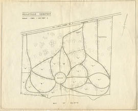
Map of the Belleville Cemetery
Part of Map collection
A map of the Belleville Cemetery grounds, before 1952. Scale: 100 feet : 1 inch.

City of Belleville and Advertisements
Part of Map collection
A hand-drawn map of Belleville, Ontario in 1950. The map itself features street names and major water ways. Advertisements surround the map. Published by S. A. Renouf Advertising Co. and drawn by F. P. Lloyd. Scale 1:15,000.
S. A. Renouf Advertising Co.

City of Belleville on Acme advertisement
Part of Map collection
A map of the City of Belleville in 1950, on an advertisement for Acme Plumbing. The map itself features street names and major water ways. Street names are at the bottom of the map. Published by S. A. Renouf Advertising Co. and drawn by F. P. Lloyd. Scale 2" : 2,000 feet.
S. A. Renouf Advertising Co.

City of Belleville on hardware advertisement
Part of Map collection
A map of the City of Belleville in 1950, on an advertisement for Walker Hardware Company Limited. The map itself features street names and major water ways. Street names are at the bottom of the map. Published by S. A. Renouf Advertising Co. and drawn by F. P. Lloyd. Scale 2" : 2,000 feet.
S. A. Renouf Advertising Co.

Part of Map collection
A map of Prince Edward County featuring information about local historical traditions, agriculture, community life and geography. Published in 1937 through Picton Times by Conger Allison. Dimensions: 72cm x 53cm.
Allison, Conger

South and Central Hastings Map
Part of Map collection
"Cummins Rural Directory Map:" A map of South and Central Hastings, in 1923, featuring post offices, hamlets and lot owners. Map is surrounded by advertisements. Published by Cummins Map Co., Toronto. Dimensions 71cm x 50.5cm.
Cummins Map Company