Wine Tour Map of Prince Edward County
- CA ON00156 M/M430-2627
- Item
- 2014
Part of Map collection
A map of Prince Edward County showing the location and information about local wineries.
Prince Edward County Winegrowers Association
750 results directly related Exclude narrower terms
Wine Tour Map of Prince Edward County
Part of Map collection
A map of Prince Edward County showing the location and information about local wineries.
Prince Edward County Winegrowers Association
Part of Map collection
A map of Hastings County showing the location and information about local agriculture businesses relevant to autumn - orchards, bakeries etc.
Hastings Stewardship Council

Town of Trenton with advertising businesses
Part of Map collection
A photocopy of a map of the Town of Trenton, circa 1915. The map features advertisements for local businesses, important sites, industries and many railways and stations.
Donated by Bruce Polmanter.
Trenton/Seymour Electric & Water Co. Limited Maps
Part of Map collection
4 maps produced for the Trenton Electric & Water Co. Limited and Seymour Power & Electric Co. Limited in the 1910s. The maps contain information regarding water towers, lines and stations.
Smith, Kerry and Chace Engineers

Trenton Electric & Water Co. Limited in Thurlow Township
Part of Map collection
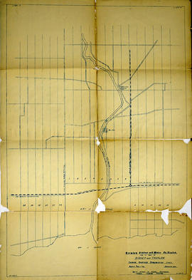
An original map produced for the Trenton Electric & Water Co. Limited, concerning their water mains, towers and substations within the Township of Thurlow. However, the map also features railways, roads and land boundaries. Circa 1910. Scale: 50 chains = 1 inch. Map composed by Smith, Kerry and Chace Engineers located in Toronto, Winnipeg, Calgary and Vancouver.
Donated by David Pershick.
Smith, Kerry and Chace Engineers
Trenton Electric & Water Co. Limited in Thurlow and Sidney Townships
Part of Map collection
An original map produced for the Trenton Electric & Water Co. Limited, concerning proposed transmission lines within the Townships of Thurlow and Sidney. However, the map also features railways, roads, mills and land boundaries. Dated March 31, 1910. Scale: 1/4 mile = 1 inch. Map composed by Smith, Kerry and Chace Engineers located in Toronto, Winnipeg, Calgary and Vancouver.
The map includes the first 4 concessions, Lots 33-38 in Sidney Township and Lots 1-13 in Thurlow Township.
Donated by David Pershick.
Smith, Kerry and Chace Engineers

Seymour Power & Electric Co. Limited in Murray Township
Part of Map collection
An original map produced for the Seymour Power & Electric Co. Limited, concerning proposed transmission lines within the Township of Murray. However, the map also features railways, roads, mills and land boundaries. Circa 1910. Scale: 50 chains = 1 inch. Map composed by Smith, Kerry and Chace Engineers located in Toronto, Winnipeg, Calgary and Vancouver.
Donated by David Pershick.
Smith, Kerry and Chace Engineers

Trenton Electric & Water Co. Limited in Sidney Township
Part of Map collection
An original map produced for the Trenton Electric & Water Co. Limited, concerning proposed transmission lines within the Township of Sidney. However, the map also features railways, roads and land boundaries. Circa 1910. Scale: 50 chains = 1 inch. Map composed by Smith, Kerry and Chace Engineers located in Toronto, Winnipeg, Calgary and Vancouver.
Donated by David Pershick.
Smith, Kerry and Chace Engineers
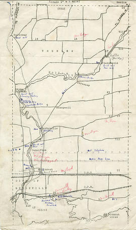
Map of Thurlow Township with annotations
Part of Map collection
A map of Thurlow Township featuring the addition of handwritten annotations. Concessions, railways, proprietors, businesses and locations are featured. The map extends from the Bay of Quinte in the southwest to Roslin the northeast. Circa 1950 (Bakelite plant opened c. 1948 and the Foxboro Cheese Factory closed in 1961).
Specific annotations are as follows: Halloway Grist Mill, Latta Bridge, Plainfield Grist, Saw Mill, O'Brien's Bridge, Grist Mill, Canning Factory Foxboro, Footbridge, Cheese Factory, Fairfields Bridge, Dam Corbyville, Distillery, Cannifton Dam, Grist & Saw Mill, Quarry & Substation, Round House, Brickyard, Graham's Dried Foods, Bell Telephone Lines, Hydro Power Lines, and Cement Works.
Belleville Transit Bus Route Maps
Part of Map collection
Each map was published by the Belleville Transit Commission and features street names, transit routes and rider fares.
Belleville Transit Commission

Aerial View of Quinte Cruising Waters
Part of Map collection
A reproduction of a pre-1949 aerial view photo located in a tourism advertisement book. The booklet advertises Quinte's cruising waters extending from Trenton to Adolphus Reach.
Ontario. Department of Lands and Forests
Plan of the town of Belleville 1869
Part of Map collection
A copy of a map planning streets and some buildings in Belleville, Ontario, 1869. Produced for the Hastings Directory. Map shows location of schools, court house, churches, banks, post office, town hall, police station, important industries.
Scale: 10 chains to an inch.

Bird's Eye View Map of Belleville
Part of Map collection
Reproduction by the Hastings County Historical Society of an 1874 Bird's Eye View of Belleville, Ontario, showing buildings that existed at that time.
The original map was drawn by Herman Brosius and printed by Charles Sober & Co. of Chicago.

Map of Belleville by Evans & Bolger 1877
Part of Map collection
An 1877 map of Belleville, Hastings County, Ontario by Evans & Bolger, surveyors. Map includes a table showing dates of plans in the registry office with plan name, wards and dates.

Map of City of Belleville and Principal Buildings
Part of Map collection
A map of Belleville, Hastings County, Ontario and its principal buildings. Produced c. 1878. Scale: 13 chains to an inch. Photocopied from Hastings County Directory at the Archives of Ontario (D-1).
Copy of Fire Insurance Map 1878
Part of Map collection
1878 Fire Insurance Map from Charles Goad's Atlas. Details streets, buildings and lots in Belleville, Ontario. Donated by Beth Green.
Chas. E. Goad Company

Map of Belleville Harbour Flood Limits and Dredging
Part of Map collection
A map of the Bellleville Harbour, in July-August 1880, featuring harbour dredging, flood limits of 1879; Flint & Holton's saw mill; Mill Island; Grand Junction Railway. By E. de Bouchinville. Scale: 400ft : 1 inch (original).
de Bouchinville, E.

Map of Parcel of Area #1 - Land Settlement
Part of Map collection
"In the High Court of Justice - Chancery Division - Morton vs. Ponton. Sketch of Parcel No. ,1 referred to in advertisement of sale therein. "
A map showing a parcel of land between the Bay of Quinte and Dundas Street East (Area #1) in Belleville, Ontario. Published in 1881. Used in land settlement matters. Printed on tissue paper. Scale: 8 chains to an inch.

Map of Railway Station, Harbour and Wharf Facilities
Part of Map collection
A map detailing the Grand Trunk Railway's station (1882), harbour and wharf facilities (1878) in Belleville, Ontario. Legends on each side of the maps describe buildings and areas. By William Michaud.
Michaud, William

Map of Dredging in Belleville Harbour
Part of Map collection
A map detailing harbour improvements, specifically areas to be dredged, in Belleville, Ontario, post 1890. The areas to be dredged are hatched lines, see bottom right Legend. By J. W. Fraser. Scale: 400 ft : 1 inch.
Fraser, J. W.