Hastings County Petition for Roads June 1862
- CA ON00156 TR/1466
- File
- 1862
File contains petitions and a report by the County Surveyor regarding road and bridge repair in Hastings County.
716 results directly related Exclude narrower terms
Hastings County Petition for Roads June 1862
File contains petitions and a report by the County Surveyor regarding road and bridge repair in Hastings County.
Hastings County Surveyor's Report to Council 1862
File contains a surveyor's report from 1862 about the condition of roads and bridges in Hastings County that was submitted to the Council.
Hastings County Jail – report of grand jury 1862
File contains letters and report about a grand jury investigation into the conditions of the addition made to the County Jail in Belleville.
Hastings County Petition for Roads Oct. 1862
File contains petitions for road repair in Hastings County from 1862.
Hastings County Shire Hall Repairs 1862
File contains communications regarding the repair of Shire Hall in Hastings County.
Hastings County Roads & Bridges Report 1862
File contains letters, reports, bylaws, and motions regarding roads and bridges in Hasting County from 1862.

Plan of part of Bleecker Estate in Belleville
Part of Map collection
A certified reproduction of the "Plan of part of Bleecker Estate, south side of Moira Street being parts of Lots # 4 & 5 in 1st Concession Thurlow, now in Belleville. Made for Trustees of Estate of late Tobia's Bleecker -being Anson Gilbert Northrup, Thomas Wills and Nelson Lingham." Many buildings are on the island - including a saw mill and Frost's Cabinet Factory. Between Moira Street and mill race are 2 dwellings and the mill building. Surveyed by John D. Evans, P.L.S., circa 1863.
This copy was made in 1972 of plan #156, as registered in the Hastings Land Registry Office.
Donated by Walter I. Watson, O.L.S.
Evans, John Dunlop, P.L.S.
File contains a newspaper account from the Ontario Intelligencer, 17 October 1963, recounting the history of St. Andrew's Gilead United Church from its foundation in 1863.

Map of Park and Building Lots Plan in Thurlow
Part of Map collection
An original map showing a plan for park and building lots on Bleecker Avenue between Concession 2 (College Street) and Bridge Street in Thurlow Township, Ontario. Along with the creation of subdivisions, Meyers Street was also being planned. Drawn by Philip Short for P. V. Elmore, P.L.S. Created on February 9, 1863 and registered 18 days later on February 27. Scale 3.5 chains to an inch.
Property of Tobias Blecker.
Short, Philip
Materials relating to William Nisbet Ponton
Four items originally owned by William Nisbet Ponton:
1) Writ of summons addressed to Francis Papineau, James Blacklock and James Hill of Belleville, defendants in a case brought by Henry Fowler, served on 10 May 1865
2) Typescript copy of Section 11 of By-law 476 of the City of Belleville, prohibiting people from setting off firearms or rockets or throwing snowballs in streets or public places in the city. By-law originally passed on 16 May 1881
3) Sale poster for auction mortgage sale of the Albion Hotel in Belleville, Ontario on 4 July 1900
4) Menu, program, seating plan, and toast list for the Sixth Congress of Chambers of Commerce of the Empire, held at the Hotel Cecil in London, England on 13 July 1906. (W. N. Ponton was one of the attendees.)
Ponton, William Nisbet

Plan of the town of Belleville 1864-65
Part of Map collection
A copy of a map planning streets and some buildings in Belleville, Ontario, 1864-65. Composed by R. L. Innes, ESQ. C.E. Produced for the Hastings Directory.
Scale: 10 chains to an inch.

Plan of Lots 26-29 in the town of Belleville
Part of Map collection
A certified reproduction of the Plan of Lot # 27 on the west side of Pinnacle Street, part of the north half of Lot # 28, part of the south half of Lot # 29 on the east side Front Street and Lot # 26. Lots were divided into 13 small lots of the estate of Late Rev. Thomas Campbell. Surveyed by Samuel M. Benson, P.L.S. in June of 1864.
This copy was made in 1972 of plan #108, as registered in the Hastings Land Registry Office.
Donated by Walter I. Watson, O.L.S.
Benson, Samuel Manson, D.P.S. & P.L.S.
Hastings County Surveyors Report Oct. 1864
File contains a report completed by Robert Francis, Surveyor, in 1864 about roads in Hastings County.
Hastings Court House & Jail; Letter from Gov. General re: dreadful conditions 1864
File contains letters, petitions, and an expense regarding the conditions and subsequent repairs to the jail and the court rooms.
Elzevir – Letter re opening a sawmill 1868
File contains a petition from 1864 for the construction of a road and a letter from 1868 regarding a Sawmill in Elzevir.
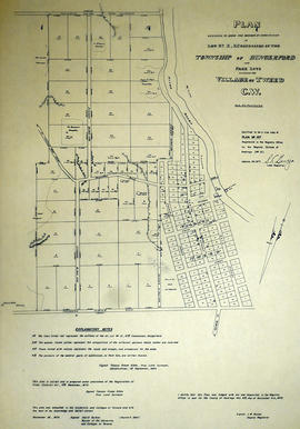
Plan of Lot 10 in the village of Tweed
Part of Map collection
A certified reproduction of the "Plan of Lot # 10 in Concession 10 of Hungerford Township into Park Lots adjoining the Village of Tweed C. W." The Village of Tweed depicts: grist mill, saw mill, and on opposite side of River: Fulling & Carding Shop. Surveyed by Thomas Fraser Gibbs, P.L.S., and signed September 1, 1864.
This copy was made in 1972 of plan #157, as registered in the Hastings Land Registry Office.
Donated by Walter I. Watson, O.L.S.
Gibbs, Thomas Fraser, P.L.S.

Plan of subdivision of part Lots 5-6 in the Township of Thurlow
Part of Map collection
A certified reproduction of the Plan of subdivision of part of Lots # 5 & 6 in the 3rd Concession of Thurlow, belonging to Jonas Canniff. Surveyed by Samuel M. Benson, P.L.S. and signed on October 20, 1864.
This copy was made in 1972 of plan #103, as registered in the Hastings Land Registry Office.
Donated by Walter I. Watson, O.L.S.
Benson, Samuel Manson, D.P.S. & P.L.S.
Thomasburg United Church centennial, 1964
File contains a printed programme of the 100th anniversary of the laying of the cornerstone of Thomasburg United Church in 1864. Includes a brief history of the church. Also present is a newspaper article concerning the history of the church and the events of the centennial celebration.
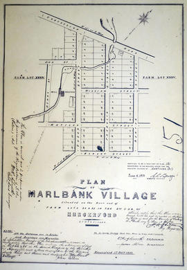
Plan of the village of Marlbank 1865
Part of Map collection
A certified reproduction of the "Plan of Marlbank Village situated on the rear end of farm Lots # 34 & 35 in 2nd Concession of Hungerford. Laid out by John Allen executor of the late James Allen." Surveyed by William R. Aylsworth, O.L.S., and signed February 1, 1865.
This copy was made in 1972 of plan #151, as registered in the Hastings Land Registry Office.
Donated by Walter I. Watson, O.L.S.
Aylsworth, William Robert, O. L. S.

Plan of part of Lot 3 and Gore in Belleville
Part of Map collection
A certified reproduction of the "Plan of part of Lot # 3 and Gore in 1st Concession of Thurlow and also Plan of part of the Estate of William Coleman situated west of Front Street Belleville." Owners/tenants of properties along Front Street, west side; the late D. B. Sole; Foundry; Doctor E. H. Coleman; Samuel Stevens, Hon. J. Ross; Mrs Roy; James Whiteford (at south end of map). There is also a Wooden Factory on the Island. Surveyed by John J. Haslett, P.L.S., and dated November 25, 1865.
This copy was made in 1972 of plan #159, as registered in the Hastings Land Registry Office.
Donated by Walter I. Watson, O.L.S.
Haslett, John James, P.L.S. & D.P.S.