Belleville

Taxonomy

Code

Scope note(s)

Display note(s)

Hierarchical terms

Belleville

Belleville

Equivalent terms

Belleville

Associated terms

Belleville

2951 Archival description results for Belleville

2951 results directly related Exclude narrower terms

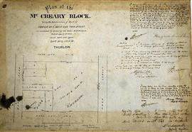
Plan of Lot XL/40 in the town of Belleville

An original, hand-painted "Plan of Lot XL [40] on the west side of Front Street in the town of Belleville. Scale 20 feet to an inch." The plan includes the River Moira in the west, a yard, an archway and Front Street in the east. Surveyed by P.L.S. John J. Haslett and signed May 14, 1870.

Haslett, John James, P.L.S. & D.P.S.

Plan of Lots 21-22 in the town of Belleville

A certified reproduction of the Plan of Lots # 21 & 22 on the east side of Pinnacle Street in Belleville. Lot # 21 owned by Robert Charles Wilkins. Lot # 22 owned by Charles George Levisconte. Surveyed by John J. Haslett, P.L.S. and signed March 9, 1854.

This copy was made in 1972 of plan #34, as registered in the Hastings Land Registry Office.

Donated by Walter I. Watson, O.L.S.

Haslett, John James, P.L.S. & D.P.S.

Plan of Lots 26-29 in the town of Belleville

A certified reproduction of the Plan of Lot # 27 on the west side of Pinnacle Street, part of the north half of Lot # 28, part of the south half of Lot # 29 on the east side Front Street and Lot # 26. Lots were divided into 13 small lots of the estate of Late Rev. Thomas Campbell. Surveyed by Samuel M. Benson, P.L.S. in June of 1864.

This copy was made in 1972 of plan #108, as registered in the Hastings Land Registry Office.

Donated by Walter I. Watson, O.L.S.

Benson, Samuel Manson, D.P.S. & P.L.S.

Plan of Lots in the Town of Belleville for John Maybee

A certified reproduction of the "Plan of Lots laid out for John Way Maybee on part of Broken Front of Lot # 5 in 1st Concession Thurlow, now within the limits of Town of Belleville." Surveyed by Samuel M. Benson, P.L.S. and signed June 7, 1847.

This copy was made in 1972 of plan #17A, as registered in the Hastings Land Registry Office.

Donated by Walter I. Watson, O.L.S.

Benson, Samuel Manson, D.P.S. & P.L.S.

Plan of lots in the Town of Belleville for Wm Dafoe

A certified reproduction of the Plan of lots surveyed for William Dafoe in the Town of Belleville. Lots bounded by Mill Street, Dafoe Street and Coulter Street. Includes property owned by G. H. Meyers with “Meyer's Hotel” depicted. Surveyed by Samuel M. Benson, P.L.S. and signed April 26, 1861.

This copy was made in 1972 of plan #98, as registered in the Hastings Land Registry Office.

Donated by Walter I. Watson, O.L.S.

Benson, Samuel Manson, D.P.S. & P.L.S.

Plan of MacNab Block in the Town of Belleville

A certified reproduction of the "Plan of MacNab Block, part Lot # 33 on east side of Front Street and part of Lot # 33 on west side of Pinnacle. Confirmed by Jabez Kellogg, Attorney for A. MacNab." Surveyed by Samuel M. Benson, P.L.S. and signed December 19, 1850.

This copy was made in 1972 of plan #21, as registered in the Hastings Land Registry Office.

Donated by Walter I. Watson, O.L.S.

Benson, Samuel Manson, D.P.S. & P.L.S.

Plan of Market Square in Belleville

A reproduction of a blueprint for Market Square between Front Street and Pinnacle Street in Belleville, Ontario. Including the Police Station, sidewalks, Beer Warehouse, dwellings etc. Surveyed by Charles D. Campbell. Signed by City Engineer, Charles A. Mott, on January 5, 1929.

Donated by the Belleville Public Library in 2014.

Mott, Charles Allan

Plan of McCreary Block in the City of Belleville (amended)

An original plan of the McCreary Block - being a subdivision of part of Park Lot # 3, the west side of Park Street - as amended, dated April 1, 1905 and laid out on Lot # 4, Concession 2, Thurlow. Surveyed by Henry Carre O. L. S.

Donated by Heritage Belleville.

Carre, Henry, O.L.S.

Plan of Meyers Common in the Township of Thurlow

A certified reproduction of the "Plan of Meyers Common - north part of Lot # 5 in 1st Concession of Thurlow Township, now the property of Benjamin Rowe, John Rowe and Burleigh Hunt." It was surveyed in 1848 and refined in 1850 by P. Elmore, P. L. S. “Mill Reserve” on Lots # 9 and 10 on the corner of Mill and Elm Streets and “Bleekers Barn Lot” on Park Street.

This copy was made in 1972 of plan #12, as registered in the Hastings Land Registry Office.

Donated by Walter I. Watson, O.L.S.

Elmore, Publius Virgillius, D.P.S.

Plan of Moodie Property in the town of Belleville

A certified reproduction of the Plan of part of town of Belleville, part of Lot # 2 in 1st Concession of Thurlow, property of J. W. Moodie. The Moodie stone home is depicted before Sinclair St. had been extended to Bridge St. West. Surveyed by Innes and MacLeod, P.L.S. and signed March 24, 1861.

This copy was made in 1972 of plan #102, as registered in the Hastings Land Registry Office.

Donated by Walter I. Watson, O.L.S.

Innes and MacLeod, P.L.S.

Plan of Murney's Block in the Town of Belleville

A certified reproduction of the "Plan of Murney's Block on North side of Bridge Street West in Belleville, designated as “Edmonston Continued” for Edmund Murney." The block includes Bridge Street West and north to Catharine Street, with Lots on Octavia Street and Isabel Street. Surveyed by John J. Haslett, P.L.S. in 1851.

This copy was made in 1972 of plan #8, as registered in the Hastings Land Registry Office.

Donated by Walter I. Watson, O.L.S.

Haslett, John James, P.L.S. & D.P.S.

Plan of Murney's Plot in the Township of Thurlow

A certified reproduction of the Plan of Murney's Plot on part of Lot # 5 in 1st Concession Thurlow for Edmond Murney. Surveyed by John Emerson, P.L.S. in 1854.

This copy was made in 1972 of plan #24, as registered in the Hastings Land Registry Office.

Donated by Walter I. Watson, O.L.S.

Emerson, John, P.L.S.

Plan of New Fire Hall No. 2

Part of a set of blueprints for the New Fire Hall No.2 in Belleville, Ontario. The hall is located on West Moira Street, between Boswell Street and Wallbridge Crescent . Drawn by John Arnold Thomson and signed October 25, 1948.

Thomson, John Arnold

Plan of Park and Village Lots in Stirling

A certified reproduction of the "Plan of Park and Village Lots in Village of Stirling. Being Lot # 23 in 9th Concession of Sidney Township for James Ross." Surveyed by John J. Haslett, P.L.S. in 1852.

This copy was made in 1972 of plan #16A, as registered in the Hastings Land Registry Office.

Donated by Walter I. Watson, O.L.S.

Haslett, John James, P.L.S. & D.P.S.

Plan of part of Bleecker Estate in Belleville

A certified reproduction of the "Plan of part of Bleecker Estate, south side of Moira Street being parts of Lots # 4 & 5 in 1st Concession Thurlow, now in Belleville. Made for Trustees of Estate of late Tobia's Bleecker -being Anson Gilbert Northrup, Thomas Wills and Nelson Lingham." Many buildings are on the island - including a saw mill and Frost's Cabinet Factory. Between Moira Street and mill race are 2 dwellings and the mill building. Surveyed by John D. Evans, P.L.S., circa 1863.

This copy was made in 1972 of plan #156, as registered in the Hastings Land Registry Office.

Donated by Walter I. Watson, O.L.S.

Evans, John Dunlop, P.L.S.

Plan of part of Block A in Sidney Township

A certified reproduction of the "Plan of Part of Block A, Concession 2, Township Sidney; laid out for Hugh Miller." Surveyed by John D. Evans, P.L.S., and signed in 1874.

This copy was made in 1972 of plan #165, as registered in the Hastings Land Registry Office.

Donated by Walter I. Watson, O.L.S.

Evans, John Dunlop, P.L.S.

Plan of part of Coleman Estate in Belleville

A certified reproduction of the "Plan of part of the Estate of C. L. Coleman, being Block on Lot # 9, on north side of Moira Street in Belleville for Charles Lester Coleman." Surveyed by John J. Haslett, P.L.S. in 1854.

This copy was made in 1972 of plan #183, as registered in the Hastings Land Registry Office.

Donated by Walter I. Watson, O.L.S.

Haslett, John James, P.L.S. & D.P.S.

Plan of part of Coleman's Estate in the Town of Belleville

A certified reproduction of the Plan of part of Coleman's Estate - E. H. Coleman's Block, owned by Everitt Hastings Coleman. Surveyed by John J. Haslett, P.L.S. in 1854. The buildings: Grist Mill, Carpenter's Shop, Paint Shop, Planing Machine Shop, Old Coal House, Chair and Sash Factory, Saw Mill.

This copy was made in 1972 of plan #26, as registered in the Hastings Land Registry Office.

Donated by Walter I. Watson, O.L.S.

Haslett, John James, P.L.S. & D.P.S.

Plan of Part of Lot #1 in the Township of Thurlow

A certified reproduction of the "Plan of part of Lot # 1 in the First Concession of Thurlow, surveyed for Asa Yeomans.” The area includes; east of Sidney Street and south of Mill Street [now West Moira Street], being on the north half of Lot # 1 in the First Concession of Township of Thurlow. Surveyed by Samuel Manson Benson D. P. S. - November 30, 1846.

Donated by Walter I. Watson, P. L. S.

Benson, Samuel Manson, D.P.S. & P.L.S.

Plan of part of Lot 2 in the City of Belleville

A certified reproduction of the "Plan part of Lot # 2, Concession 1, Thurlow, being the subdivision of Lots # 44-53 both inclusive on the Moodie Block, Town of Belleville for Angus McFee." Surveyed by Evans and Bolger, P.L.S. and signed August 15, 1874.

This copy was made in 1972 of plan #184, as registered in the Hastings Land Registry Office.

Donated by Walter I. Watson, O.L.S.

Evans and Bolger

Results 2101 to 2120 of 2951