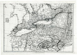
Ontario

Taxonomy

Code

Scope note(s)

Source note(s)

Display note(s)

Equivalent terms

Ontario

Associated terms

Ontario

402 Archival description results for Ontario

Only results directly related

Parts of Ontario and USA in 1834

A map showing settlements of Ontario and part of the United States in February 1834 by J. Arrowsmith. The total area extends from Lake Huron East to Montreal and south Ohio to Long Island.
Received from the Archives of Canada's map collection - 11 May 1977.

Arrowsmith, John

Map of Proposed bridge at mouth of the River Trent

A copy of an original map by N. H. Baird showing a harbour and bridge proposal at the Mouth of the River Trent - October 26, 1832.
Photocopied by the Archives of Ontario.

Baird, Nicol Hugh

Stanley Park Subdivision in the City of Belleville

A certified reproduction of the "Stanley Park Subdivision, part of Lot # 12, Concession 1, Township of Thurlow, Stanley Park Ltd. Owner John M. Parrot & Bernice W. Parrot.” The area includes; east of Farley Avenue and north of Bridge Street East, Lots # 1 to 294 and Block A-C. Note, Blocks B and C are dedicated for Park & School purposes. Surveyed by John Thomas Ransom, O. L. S. and signed February 14, 1958.

Donated by Walter I. Watson, P. L. S.

Ransom, John Thomas, P.L.S.

Surveying for Settlement Map of Ontario

A map of Ontario to eastern Quebec entitled "Surveyed for Settlement." Produced to commemorate the organization's centennial 1892-1992. Pictures and stories of early surveying surround the map. Scale 1:2,775,000.

Donated by the Belleville Public Library in 2014.

Association of Ontario Land Surveyors

Topographical Map of east Belleville - Canada sheet

A topographical map of east Belleville - Canada sheet #31 C/3. Area extends from Tyendinaga Mohawk Territory to Lennox & Addington East to West and South to Picton Bay. Map was published by the Department of National Defence in November 1962. Scale 1:50,000.

Canada. Department of National Defence

Map of Town Plot at mouth of Trent River

A map of a town plot at the mouth of the Trent River in the Newcastle District. The map features numbered lots, present streets and water ways. Scale: 1 inch = 2 chains. Originally surveyed by F. P. Rubidge, D.P.S., in 1834. This copy was issued September 23, 1926.

Rubidge, Frederick Preston, D.P.S.

Plan of the town plots of Trenton East

A certified reproduction of an original map showing a plan of the town plots in Trenton East. Specifically located in "Lot A in the core of Sidney". Scale: 1:2000.
Donated by Dorothy Ashton in 1987.

Map of Upper Canada and United States

A map showing settlements of Upper Canada and part of the United States in 1834 by J. Arrowsmith.
Received from the Archives of Canada's map collection - July 9, 1971.

Arrowsmith, John

Aerial Photograph of Oshawa and Whitby

Oshawa & Whitby, Map # 2055 showing areas of; Oshawa & Whitby in Township of East Whitby and Township of Whitby, from Lake Ontario through the 8th Concession and Darlington Township. Then, from Lake to 8th Concession Lots # 30 to 35-showing Ontario Hydro Line, gas and oil pipelines. From Ontario Hydro. Dated 1972. Scale: 1 inch = 2000 feet.

Aerial Photograph of Bowmanville

Bowmanville, Map # 2054 showing areas of; Bowmanville and Darlington Township, Concession 1 to 10, Lots # 1 to 29, Showing Ontario Hydro Line, gas and oil pipelines and proposed Darlington Generating Station site. From Ontario Hydro. Dated 1972. Scale: 1 inch = 2000 feet.

Aerial Photograph of Port Hope

  • CA ON00156 M/M470-2781 - 2794/2786
  • Item
  • 21 Dec 1972
  • Part of Map collection

Port Hope, Map # TD16450Z00 (Mosaic 5 of 5) showing areas of; Hope Township from Lake Ontario to Concession 9, Hamilton Township and Lots # 30 to 35, Clarke Township Lots # 1 to 3, showing Hydro Lines and Pipelines. From Ontario Hydro. Dated December 21, 1972. Scale: 1 inch = 2000 feet.

Aerial Photograph of Clarke Township

Clarke Township, Map # TD16450Z00-Mosaic 2 of 4 showing areas of; Clarke Township from Lake Ontario to Concession 10, Hope Township and Lots # 20 to 35 showing Hydro Lines and Pipelines. From Ontario Hydro. Dated 1972.

Map of the City of Belleville circa 1913

The total section of Belleville is not included on only one map, the 4 maps are needed. The map appears to be about the time the street numbers on Front Street were changed. Also about the time when the CPR was included with the Canadian Northern Rail bed through Belleville and the Church Street Passenger Station became “Union Station”.
The area covered on the maps extends from the Bay of Quinte north to College Street and from Sidney Street east to include both sides of MacDonald Avenue.

CNO Railway from Toronto to Ottawa 1910

A photocopy of a map detailing the CNO railway from Toronto to Ottawa. Dated November 15, 1910. Annotations of proprietors and boundaries have been added to the map.

Results 61 to 80 of 402