Ontario

Taxonomy

Code

Scope note(s)

Source note(s)

Display note(s)

Equivalent terms

Ontario

Associated terms

Ontario

5997 Archival description results for Ontario

402 results directly related Exclude narrower terms

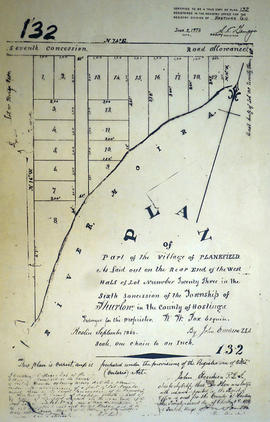
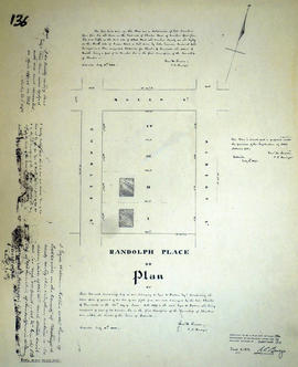
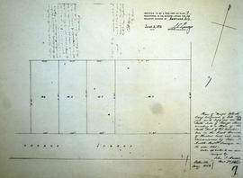
Plan of part of the village of Frankford

A certified reproduction of a "Plan...of the village of Frankford. ” The area includes; part of Frankford Village westerly from King St. to Lots # 1-2 in Sidney Township and northerly from Sidney Street to Adelaide Street, including Cold Creek. Dated April 1853. Surveyed by J. S. Peterson, P.L.S.

This reproduction was made on April 9, 1981 and approved by the Land Registrar.

Donated by Walter I. Watson, P. L. S.

Peterson, J.S., P.L.S.

Plan of part of the village of Plainfield

A certified reproduction of the "Plan of part of the Village of Plainfield, being also a part of Lot # 24, Concession 7, Thurlow Township, for the trustees & executor of Fairfax Fearnley.” Surveyed by Evans and Bolger, P.L.S., and dated January 8,, 1885.

This copy was made in 1972 of plan #239, as registered in the Hastings Land Registry Office.

Donated by Walter I. Watson, P. L. S.

Evans and Bolger

Plan of part of the village of Shannonville

A certified reproduction of the "Plan of part of Shannonville laid out in 1839 on part of [the] south half of Lots # 5 & 6 in 1st Concession, south of road in Township of Tyendinaga." Surveyed by Samuel M. Benson P.L.S., and signed June 15, 1872.

This copy was made in 1972 of plan #153, as registered in the Hastings Land Registry Office.

Donated by Walter I. Watson, O.L.S.

Benson, Samuel Manson, D.P.S. & P.L.S.

Plan of part of the village of Springbrook

A certified reproduction of the "Plan of part of village of Springbrook on Lot # 13 in the 9th and 10th Concession of Rawdon - George D. Wiggins, owner.” Includes lots on both sides of Front, Main and Church Streets. Surveyed by Edward Christopher B. Caddy, P.L.S. & D.L.S. Plan registered March 7, 1885.

This copy was made in 1972 of plan #241, as registered in the Hastings Land Registry Office.

Donated by Walter I. Watson, P. L. S.

Caddy, Edward Christopher B., P.L.S. & D.L.S.

Plan of Part of the west side of Front Street in the Town of Belleville

A photocopy of the "Plan of Part of the West side of Front Street in the Town of Belleville." Surveyed by John J. Haslett D. P. Surveyor, circa 1850. Labels on the plan include Roy (a brewery), Courtney, J. Ross Esq., arches, S. Stevens, raceway, the Gore, D. B. Sole, J. Reynolds and Store.

Donated by the Belleville Public Library in 2014.

Haslett, John James, P.L.S. & D.P.S.

Plan of part of the Yeomans Estate in the Township of Thurlow

A certified reproduction of the "Plan of part of the Yeomans Estate - “Yeomans Block” - on Lot # 1, Concession 1, Thurlow and lying North of Moira Street in Belleville, for Horace Yeomans, John Lewis & James Ross, executives of Asa Yeomans.” The total area surveyed includes Sidney Street on the west side, College Street in the north, Frank Street in the east and Moira Street West in the south. Surveyed by Evans and Bolger, P. L. S. Plan registered in August 1875.

This copy was made in 1972 of plan #187, as registered in the Hastings Land Registry Office.

Donated by Walter I. Watson, P. L. S.

Evans and Bolger

Plan of Phippen's Block in the Township of Thurlow

A certified reproduction of the "Plan of Phippen's Block - part of Lot # 7 in Second Concession Thurlow owned by John Phippen." Surveyed by John J. Haslett, P.L.S. and signed May 15, 1853.

This copy was made in 1972 of plan #19, as registered in the Hastings Land Registry Office.

Donated by Walter I. Watson, O.L.S.

Haslett, John James, P.L.S. & D.P.S.

Plan of Plainfield village 1873

An original plan of Plainfield Village, part of the south end of Lot # 24, in Concession 7, Township of Thurlow. The River Moira runs through the centre of the village. Buildings, names of grantees/grantors etc. are depicted. Surveyed by P. L. S. John Emerson and signed in May 1873. Scale one chain to an inch.

Donated by the Glanmore National Historic Site in 2016.

Emerson, John, P.L.S.

Plan of Plainfield village 1875

A copy of an original plan of Plainfield Village, part of the south end of Lot # 24, in Concession 7, Township of Thurlow. The River Moira runs through the centre of the village. Surveyed by P. L. Surveyors Evans and Bolger and signed December 4, 1875. Scale two chains to an inch.

Donated by the Glanmore National Historic Site in 2016.

Evans and Bolger

Plan of Planefield in the Township of Thurlow

A certified reproduction of the Plan of Planefield in west Lot # 23 in 6th Concession, Thurlow Township, for proprietor William W. Fox. Surveyed by John Emerson, P.L.S. and signed September 1868.

This copy was made in 1972 of plan #132, as registered in the Hastings Land Registry Office.

Donated by Walter I. Watson, O.L.S.

Emerson, John, P.L.S.

Plan of Point Ann village in the Township of Thurlow

A certified reproduction of the "Plan of the village of Point Anne, parts of Lots # 18 to 25, Broken Front Concession of Thurlow Township.” Surveyed by Charles D. Campbell, O. L. S. of J. Walter Evans & Company, Engineers & Surveyors. Signed May 1, 1929.

This copy was made in 1972 of plan #573 registered in the Hastings Land Registry Office.

Donated by Walter I. Watson, P. L. S.

Campbell, Charles Donald, O.L.S.

Plan of Ponton's Block in the Town of Belleville

A certified reproduction of the Plan of Ponton's Block, being Lots # 21 & 22 on the south side of Bridge Street West, Belleville, for William Hamilton Ponton, on the Commercial Bank Plan. Surveyed by John J. Haslett P.L.S. in 1853.

This copy was made in 1972 of plan #27, as registered in the Hastings Land Registry Office.

Donated by Walter I. Watson, O.L.S.

Haslett, John James, P.L.S. & D.P.S.

Plan of Quinte in the Township of Tyendinaga

A certified reproduction of the Plan of Quinte, laid out on Lot # 5, 1st Concession of Tyendinaga Township, property of L. A. Appleby. Map shows - Shannonville Station ground and also Grand Trunk Railway. Surveyed by Publius V. Elmore, P.L.S. and signed March 3, 1856.

This copy was made in 1972 of plan #81, as registered in the Hastings Land Registry Office.

Donated by Walter I. Watson, O.L.S.

Elmore, Publius Virgillius, D.P.S.

Plan of Randolph Place in the town of Belleville

A certified reproduction of Randolph Place, or a plan of 4 Lots, each ½ acre belonging to Ezro W. Holton - being part Lot # 6 in 1st Concession Thurlow now in Belleville. Depicted are the 2 large brick homes on Randolph Place lots # 1 and 2. Surveyed by Samuel M. Benson, P.L.S. and signed July 11, 1870.

This copy was made in 1972 of plan #136, as registered in the Hastings Land Registry Office.

Donated by Walter I. Watson, O.L.S.

Benson, Samuel Manson, D.P.S. & P.L.S.

Plan of Rectification Survey of Madoc Township

A certified reproduction of a “Plan showing the Rectification Survey... of the Township of Madoc.” The area contained includes; northern lots #30, 31, 32 on concessions 1-11 (inclusive) in Madoc Township. Originally surveyed by Charles Fraser Aylsworth, P. L. S. and produced on March 18, 1891.

This reproduction was made on June 5, 1972 and approved by the Deputy Registrar.

Donated by Walter I. Watson, P. L. S.

Aylsworth, Charles Fraser Sr., P.L.S.

Plan of Reid's Block in the Township of Thurlow

A certified reproduction of the "Plan of Reid's Block: Lots # 55 & 56 on the north side of George Street according to a plan of south part of Lot #1 in First Concession Thurlow by John J. Haslett in 1845." Surveyed by John J. Haslett, P.L.S. and signed in May 1852.

This copy was made in 1972 of plan #7, as registered in the Hastings Land Registry Office.

Donated by Walter I. Watson, O.L.S.

Haslett, John James, P.L.S. & D.P.S.

Plan of Re-subdivision of Lot 7-24 in the Town of Trenton

A certified reproduction of the "Plan of Resubdivision of Lots # 7 to 24 inclusive and Lot # 48, Bowen Crescent, Downs Park Ave and Coulter Crescent as shown on Reg. Plan 775, Trenton, owner Downs Coulter & Co. (Canada) Ltd.” The area includes; Trenton- Lots # 7 to 31 on Coulter Crescent, North of Prince Charles School grounds and Westerly from Dufferin St. to Hanna Park. Surveyed by W. J. Pattison, O. L. S. and signed July 22, 1965.

Donated by Walter I. Watson, P. L. S.

Pattison, William James, O.L.S.

Plan of Re-subdivision of Lots # 33 & 34 in the town of Trenton

A certified reproduction of the "Plan of Resubdivision of Lots # 33 & 34 West of North Byron St. on Evans & Bolger Plan of Town of Trenton.” The area surveyed includes; 24 Lots West of North Byron Street and on both sides of Roscoe Avenue. Surveyed by W. J. Pattison, O. L. S. and signed October 22, 1954.

This copy was made in 1972 of plan #950A, as registered in the Hastings Land Registry Office.

Donated by Walter I. Watson, P. L. S.

Pattison, William James, O.L.S.

Plan of Re-subdivision of Lots 10-11 in the Town of Trenton

A certified reproduction of the "Plan of Resubdivision of part of Lots # 10 & 11 East Campbell St. Plan 112- Town of Trenton.” The area surveyed includes; East of Campbell St. and North of Dixon Drive, being Lots on Coleman Heights. Surveyed by W. J. Pattison, O. L. S. and signed October 22, 1953.

This copy was made in 1972 of plan #942, as registered in the Hastings Land Registry Office.

Donated by Walter I. Watson, P. L. S.

Pattison, William James, O.L.S.

Plan of Re-subdivision of Lots 10-11 in the Village of Tweed

A certified reproduction of the "Plan of Resubdivision of Part of Lots # 10, 11, Concession 10, Hungerford Township, Adjoining Village of Tweed, for Dr. Timotheus E. Pomeroy.” Surveyed by C. Fraser Aylsworth Jr., P.L.S., and signed August 6, 1890.

This copy was made in 1972 of plan #294, as registered in the Hastings Land Registry Office.

Donated by Walter I. Watson, P. L. S.

Aylsworth, Charles Fraser Jr., O.L.S.

Results 3961 to 3980 of 5997