Annual Report of the Department of Public Highways, Ontario, 1922
- CA ON00156 2024-013
- Pièce
- 1923
Sans titre
Annual Report of the Department of Public Highways, Ontario, 1922
Sans titre

Hepburn, Mitchell & the Liberal Party, 1930-37; essay by John G. Plumpton
Fait partie de HCHS Textual Records collection: Files 1500 to 1999
File contains a history of Mitchell F. Hepburn and the Ontario Liberal Party from 1930 to 1937.
Aerial Photograph of Hamilton and Hope Townships
Fait partie de Map collection
Hamilton & Hope Townships, Map (order) 841-5711 showing areas of; Hamilton & Hope Townships-including Cobourg & Port Hope showing Hydro lines and gas & oil pipelines. Dated August 27, 1973. Scale: 1 inch = 2000 feet.

Proposed Towns and Military Roads of Upper Canada
Fait partie de Map collection
Poor reproduction of a sketch of Upper Canada to show places designated by Lt. Gov. Simcoe for towns and proposed military roads, circa 1796. The map was published by B. M. Kings.

Reproduction of a map of Upper Canada
Fait partie de Map collection
Reproduction of a map showing "the Routes Lt. Gov. J. G. Simcoe took on trips" throughout Upper Canada from March 1792 to September 1795. The map was charted by Lt. Gov. Simcoe. A good depiction of the area now referred to as Southern Ontario and his plans for a capital there - "London." This map was published as part of "Charting Our Past" from the Archives of Ontario by Stonehouse Publications.
Scale: about 20 miles to an inch.

37 Polling Subdivisions of Belleville
Fait partie de Map collection
A map showing the 37 polling subdivisions of Belleville, Hastings County, Ontario. Composed by Charles Mott from the City in August 1958 and published in The Ontario Intelligencer on 28 November 1958.
Sans titre
The Conservation Authorities Act - Bill 90
Fait partie de HCHS Textual Records collection: Files 3500 to 3916
The file contains a copy of Bill 90; "An Act to amend The Conservation Authorities Act", titled "The Conservation Authorities Act-Revised Statues of Ontario, 1950, Chapter 62 as amended to 1959." Ontario Department of Planning and Development, Toronto.
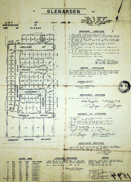
Glenarden Subdivision in the City of Belleville
Fait partie de Map collection
A certified reproduction of the "Glenarden Subdivision- part of Lot # 37, Concession 2, Township of Sidney, now in City of Belleville- owner A L M O Developments Ltd.” The area includes; north of C.N. Railway, north to both sides of College Street West. Lots # 1 to 65 and Blocks A, B, C on Progress Avenue, Glenarden Crescent, Westmount Drive, Walden Circle, College Street West and Thorncliffe Drive. Surveyed by Thomas S. Ransom, O. L. S. and signed June 17, 1964.
Donated by Walter I. Watson, P. L. S.
Sans titre

Hydrographic Map of Plans in Bay of Quinte
Fait partie de Map collection
A hydrographic map of Plans in the Bay of Quinte, Ontario, Canada. 4 inset maps are included of the 1) Trenton and Approaches, 2) Belleville, 3) [Racist slur redacted] Narrows, and 4) Telegraph Narrows. Nautical surveys completed by Col. W. P. Anderson in 1893 and Mr. E. A. Ghysens in 1934. Map printed March 25, 1952. Published by the Canadian Hydrographic Service, Department of Mines and Technical Surveys, Ottawa.
Sans titre

Topographical Map of Belleville - Canada sheet
Fait partie de Map collection
A topographical map of Belleville - Canada sheet #31 C/3 (west half). Area extends from North-Honeywell corner to South-Conscecon Lake and from East- Hungry Bay to West [racist slur redacted] Narrows. Map was published by the Department of National Defence in 1950. Scale 1:50,000.
Sans titre
Map of the City of Belleville 2017-2018
Fait partie de Map collection
A map of Belleville, Ontario featuring the Bay of Quinte to Clearview Road and Wallbridge Loyalist Road to Craig Road.
Sans titre
Belleville Transit Bus Route Maps
Fait partie de Map collection
Each map was published by the Belleville Transit Commission and features street names, transit routes and rider fares.
Sans titre

Reproduction of a map of the province of Upper Canada
Fait partie de Map collection
Reproduction of a map showing new settlements, townships, counties etc.in the province of Upper Canada as of April 12, 1800. The total area spans from Quebec to Lake Huron and from Lake Michigan to New Hampshire then south to Pennsylvania in the U.S.A. This was the first printed map of Upper Canada, showing all settlements since 1784. Charted by D. W. Smith, Esq., Surveyor General London and published by W. Faden.
This map was published by Stonehouse Productions as part of "Charting Our Past" from the Archives of Ontario.
Sans titre

Reproduction of a map of Canada West, formerly Upper Canada
Fait partie de Map collection
Reproduction of a map showing regions within "Canada West, formerly Upper Canada " 1850. The map is divided in 3 parts: Canada West formerly Upper Canada, part 2 Vicinity of the Falls of Niagara and part 3 The City of Toronto and its environs. In 1849, the County succeeded the District as the division for municipal and judicial purposes in Canada West. That along with recent transportation developments. Composed and published by Thomas Cowperthwaite & Co. in the Clerk Office of the District Court of the Eastern District of Pennsylvania.
This map was published by Stonehouse Productions as part of "Charting Our Past" from the Archives of Ontario.
Sans titre

Reproduction of a map of the Montreal, Ottawa and Georgian Bay Canal
Fait partie de Map collection
Reproduction of a map showing the "Montreal, Ottawa, Georgian Bay Canal" by G. L. Bourchier, C.E., Ottawa, Ontario, February 28, 1898. Map includes some subsidiary notes persuading Public Works Canada to adopt this canal. It eventually floundered when the inability of large ships to pass was realized.
This map was published by Stonehouse Productions as part of "Charting Our Past" from the Archives of Ontario.
Sans titre

Reproduction of a topographical Map of the New Welland Canal
Fait partie de Map collection
A reproduction of a topographical map showing the New Welland Canal and the country lying between Allanburgh and Port Dalhousie, by Thomas Monro and John Page (Chief Engineers of Canals). The Welland Canal shows the extent of communities along the canal, government lands along the canal and private owners of lands. The information on the map is from surveys completed in 1870-1871. Scale: 5 feet to an inch.
This map was published by Stonehouse Productions as part of "Charting Our Past" from the Archives of Ontario.
Sans titre

Reproduction of map of Province of Canada, western sheet
Fait partie de Map collection
Reproduction of a map showing regions of the western part of the province of Canada, in 1865. It features transportation and urban developments two years before Confederation, along with increased knowledge of the topography in northern regions, particularly in Canada East. Elevations are given for the Huron and Ottawa territory. Composed by Keith Johnston F. R. S. E. Published by W. & A. K. Johnston Edinburgh.
This map was published by Stonehouse Productions as part of "Charting Our Past" from the Archives of Ontario.
Sans titre

Reproduction of Carte des Cinq Grands Lacs du Canada
Fait partie de Map collection
Map showing "The 5 Big Lakes of Canada" by Jacques Nicholas Bellin, Paris, 1764. Bellin produced a maritime atlas containing this map, showing the topography, forts, portages and the Mission Ste. Marie in the Great Lakes area. This map was published by Stonehouse Productions as part of "Charting Our Past" from the Archives of Ontario.
Sans titre
Restoring Water Quality in the Bay of Quinte
Fait partie de Map collection
A double sided, folded map discussing pollution sources in the Bay of Quinte - where they are located, how they were created and how to clean up the pollutants.
Canoe Routes in the Moira River Watershed
Fait partie de Map collection
A double sided, folded map showing the location of canoe routes within the Moira River Watershed.
Sans titre