- CA ON00156 TR/3714
- File
- 1869
File contains original Land Grant to Daniel Clements dated 15-September-1869 for 31 acres composed of Lot No. 58 on the south west side of the Hastings Road, Township of Tudor, in the County of Hastings.
File contains original Land Grant to Daniel Clements dated 15-September-1869 for 31 acres composed of Lot No. 58 on the south west side of the Hastings Road, Township of Tudor, in the County of Hastings.

Tudor Township : Gilmour / by Mrs. Thomas Jenkins
File contains a photocopied typescript brief history of the settlement of Gilmour in Tudor Township and the development of the lumbering industry in the area.
Limerick Township : petition to separate from Tudor Township
File contains a manuscript report of the Hastings County Council Committee of Whole, 1868, finding against a petition for the separation of Wollaston and Limerick Townships from Tudor Township and the creation of separate township councils.
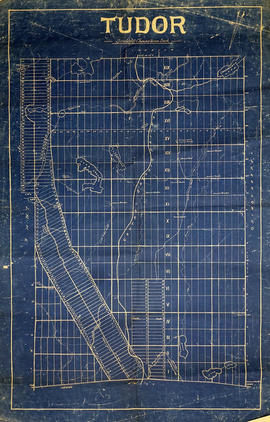
Part of Map collection
A blueprint reproduction of a map of Tudor Township in Hastings County, Ontario. The map features the names of neighboring townships, lot and concession numbers, rivers, lakes, creeks and meadows. Original map circa 1865. Scale 40 chains to an inch.

Map of Hastings with the Principal Villages and the City of Belleville
Part of Map collection
A map of Hastings County including the Town of Belleville and other principal villages:
Trenton, Madoc, Marmora, Tweed, Bridgewater, Stirling, Wicklow, Bangor, Herschel, Monteagle, Carl, Dungannon, Wollaston, Limerick, Cashel, Tudor, Grimsthorpe, Elzevir; Rawdon, Huntingdon, Hungerford, Sidney, Thurlow, Tyendinaga.
Scale: 3 miles =1 inch. Published by Evans & Bolger, P. L. Surveyors, P.L.S. in 1879-1880.
Evans and Bolger

Plan of Millbridge in the Township of Tudor
Part of Map collection
A certified reproduction of the Plan of Millbridge, laid out on Grant Lot 21 east and 21 west, on Hastings Road in Tudor Township, for R. M. Norman. Surveyed by C. F. Aylsworth Sr., P.L.S. and signed March 28, 1867.
This copy was made in 1972 of plan #116, as registered in the Hastings Land Registry Office.
Donated by Walter I. Watson, O.L.S.
Aylsworth, Charles Fraser Sr., P.L.S.
Aerial Photograph of Tudor Township
Part of Map collection
Tudor Township, Map # 69.4432,6.275 showing areas of; Tudor Township- near Glamire Village on the Hastings Road, including the Beaver Creek and part of Glamire Lake and the road going North Easterly off Hastings Road at Glanmire. Published by the Department of Mines and Technical Surveys. Surveyed by EHR. Circa 1977.
Canada. Department of Mines and Technical Surveys
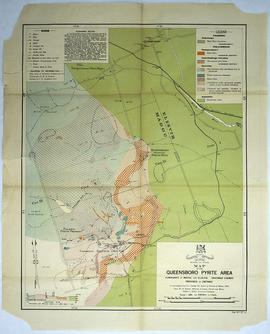
Map of the Queensboro Pyrite Area
Part of Map collection
An original map of the Queensboro area, indicating specific geological areas and signs. Includes the Townships of Madoc and Elzevir in the County of Hastings, Ontario. Dated 1913. Published by the Ontario Department of Lands, Forests and Mines. Scale: 800 feet to an inch.
Donated by David Pershik.
Ontario. Department of Lands and Forests
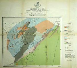
Mineral Map of the Gilmour Area
Part of Map collection
An original map of the Gilmour area, indicating specific geological areas and signs. Includes the Townships of Limerick and Tudor in the County of Hastings, Ontario. Dated 1913. Published by the Ontario Department of Lands, Forests and Mines, with a compilation of information completed by W. R. Rogers.
Donated by David Pershik.
Ontario. Department of Lands and Forests
Subdivision of Lots 22-23 in the Township of Tudor
Part of Map collection
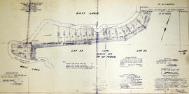
A certified reproduction of the "Subdivision of part Lots # 22 & 23, Concession XIX, Township of Tudor, for Herbert Moore.” The area includes; shore property between Bass Lake and Moore's Road being Lots # 30 to 46, inclusive, beginning at Concession Road between Townships of Tudor & Limerick. Surveyed by John Thomas Ransom, O. L. S. and signed August 9, 1957.
Donated by Walter I. Watson, P. L. S.
Ransom, John Thomas, P.L.S.
Subdivision of part of Lots 23-25 in the Township of Tudor
Part of Map collection
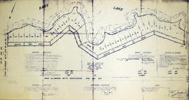
A certified reproduction of the "Subdivision of part of Lots # 23, 24, 25, Concession XIX, Township of Tudor.” The area includes; Lots # 1 to 28, Blocks A - B and Austin Bay Road along the shore of Bass Lake in Lot # 25, Concession XIX, Tudor Township. Surveyed by Thomas Ransom, O. L. S. and signed August 30, 1961.
Donated by Walter I. Watson, P. L. S.
Ransom, Thomas Saunders, P.L.S.

Subdivision of part of Lots 22-23 in the Township of Tudor
Part of Map collection
A certified reproduction of the "Subdivision of part of Lots # 22 and 23, Concession XIX, Township of Tudor.” The area includes; Bass Lake, Lots # 1 to 17 and Blocks A, B, C within the boundaries laid out and Austin Bay Road. Surveyed by John Thomas Ransom, O. L. S. and signed September 15, 1960.
Donated by Walter I. Watson, P. L. S.
Ransom, John Thomas, P.L.S.
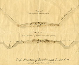
Part of Map collection
A cross-sectional plan regarding the formation of Madoc and Tudor Roads. Scale: 4 feet : 1 inch.

Plan of Hastings for Hastings Directory
Part of Map collection
A map of Hastings County outlining townships:
Marmora, Lake, Madoc, Tudor, Grimsthorpe, Elzevir; Rawdon, Huntingdon, Hungerford, Sidney, Thurlow, Tyendinaga - as well as the northern townships.
Inset is "the Village of Marmora." Surveyed by H. A. F. Macleod, C.E. and P.L.S. Published by W. A. Little Lith., Montreal in the 1864-1865 copy of the Hastings Directory . Scale: 1:190,000.
MacLeod, Henry Augustine Fitzgerald, P.L.S.
Map of Land Ownership and Fish Species in Bancroft-Mazinaw
Part of Map collection
A map describing areas of land ownership and fish species in Bancroft/Mazinaw. The map covers the following townships:
Hastings County: Lake, Tudor & Grimsthorpe
Lennox and Addington County: Ashby, Denbigh, Effingham, Abinger & Anglesea
Frontenac County: Barrie, Clarendon, Miller, North Canonto, South Canonto, & Palmerston
Scale 1cm:1km. Published by the Ontario Ministry of Natural Resources in 1993.
Ontario. Ministry of Natural Resources and Forestry

Lloyd's Map of Hastings County
Part of Map collection
A map of Hastings County outlining the twelve townships:
Marmora and Lake, Madoc, Tudor, Grimsthorpe, Elzevir; Rawdon, Huntingdon, Hungerford, Sidney, Thurlow, Tyendinaga. The northern townships are pictured on the right side.
As well as, the lots and concessions. Circa 1922. Scale: 1.5 miles: 1 inch. Published by Lloyd's Maps, Map Publisher.
Lloyd's Map, Map Publisher

Map of Hastings with townships
Part of Map collection
A map of Hastings County outlining the twelve townships:
Marmora and Lake, Madoc, Tudor, Grimsthorpe, Elzevir; Rawdon, Huntingdon, Hungerford, Sidney, Thurlow, Tyendinaga.
As well as, the lots and concessions. Circa 1916.Scale: 4 miles: 1 inch.
Donated by K.G.M. Ross.

Hastings with Town of Belleville and principal villages
Part of Map collection
A map of Hastings County including the Town of Belleville and other principal villages:
Trenton, Madoc, Marmora, Tweed, Bridgewater, Stirling, Wicklow, Bangor, Herschel, Monteagle, Carl, Dungannon, Wollaston, Limerick, Cashel, Tudor, Grimsthorpe, Elzevir; Rawdon, Huntingdon, Hungerford, Sidney, Thurlow, Tyendinaga.
Scale: 3 miles =1 inch. Published by John P. Evans, P.L.S. in 1869.
Evans, John Dunlop, P.L.S.
The file contains a brief history of Walter Brett and Family who settled at Brett's Lake in 1862.
Wicklow Township Field Notes - 1858-1861
Reports and field notes on the Township of Wicklow's survey. 34 pages.