- CA ON00156 M/M450-1506
- Unidad documental simple
- c. 1865
Parte deMap collection
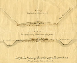
A cross-sectional plan regarding the formation of Madoc and Tudor Roads. Scale: 4 feet : 1 inch.
10 resultados directamente relacionados Excluir términos relacionados
Parte deMap collection
A cross-sectional plan regarding the formation of Madoc and Tudor Roads. Scale: 4 feet : 1 inch.

Parte deMap collection
A blueprint reproduction of a map of Madoc Township in Hastings County, Ontario. The map features the names of neighboring townships, lot and concession numbers, Central Ontario Railway, Moira River, a mill site and springs. Circa 1880. Scale 40 chains to an inch.

Townships of Hastings County with advertisements
Parte deMap collection
A map of Hastings County, in 1932, showing lakes, rivers, cities, towns and townships. A list of businesses within the county are on the right. Drawn exclusively for and published by Croydon Publishing Company.
Sin título
Hydro-Electric Power Commission of Ontario, Tweed-Section
Parte deMap collection
An original map produced for the Hydro-Electric Power Commission of Ontario, concerning hydro power lines, stations and transformers. However, the map also features railways, roads and land boundaries.
This map is the West Centre Section - Tweed ROA. The total area includes parts of Rawdon, Marmora, Huntingdon, Madoc, Hungerford, and Elzevir Townships. Dated October 16, 1951. Scale: 1.2 inches = 1 m.
Donated by David Pershik.
File contains a newspaper clipping and photocopied manuscript history of Madoc Township from early French exploration in 1615 to ca. 1965, including a discussion of the creation of roads, schools and local churches. The historical research was composed by Mrs. Ken Bateman for Gerry Boyce as background for Historic Hastings.
Fowler - Wilkinson Coach Lines
File contains a time table for the Fowler-Wilkinson Coach Lines (Belleville-Madoc-Bancroft-Maynooth-Lake St. Peter) effective June 1, 1958
Madoc Township : lodges and railroads
File contains photocopied manuscript notes on Orange Lodge branches and other social organizations including the Women's Institute and the Oddfellows in the period from 1885-ca. 1949. Also contains brief manuscript notes on railways in Madoc Township from ca. 1882-1964.
Aerial Photograph of Madoc Township
Parte deMap collection
Madoc Township, Map # A18256-148 showing areas of Hwy 62 at Bannockburn and the road east to Cooper. The railway parallel with Hwy 62. The Ontario Hydro easement running west from Cooper. By the Air Photographic Production Division of the Deptartment of Mines & Technical Surveys - Government of Canada.
Sin título
Aerial Photograph of Madoc Township
Parte deMap collection
Madoc Township, north part Bannockburn with Hwy 62, the railway, and the Bannockburn Road running east toward Cooper. By the Air Photographic Production Division of the Deptartment of Mines & Technical Surveys - Government of Canada.
Sin título
This file contains: 1) A photocopied typed article titled "Telegraph Island Light", about the lighthouse erected 1870 in the Bay of Quinte; 2) A timetable for the steamer Varuna, circa 1920, Captain A. Hicks; 3) A photocopy of the obituary for Rev. James Rollins born 28 October 1865 in Madoc and died 7 February 1943 in Kingston.