Mecklenburg, District of Proclamation by George III, July 24, 1788 - Establishing same
- CA ON00156 TR/3526
- File
- 1788
Proclamation made by George III on the formation of the District of Mecklenburg.
12 results directly related Exclude narrower terms
Mecklenburg, District of Proclamation by George III, July 24, 1788 - Establishing same
Proclamation made by George III on the formation of the District of Mecklenburg.
Willson, John Metcalfe - Papers
File contains original documents, presented to the Hastings County Historical Society in 1960; Biographical sketch written on 22-September-1869 covers the years 1862 to 1869 when Willson was teaching school in the southern part of Hastings County; educational papers; legal papers; correspondence and a poem entitled "To The Mohawks".
Wilkins, Col. Charles, 1782-1867
A history on Col. Charles Wilkins and notes made by Mr. Gerald Boyce. 13 pages.
Ontario Historical Society Records, Vol. XLV, #3, 1953
File contains a print copy of Ontario Historical Society Records, Volume XLV Number 3. This issue includes information about Molly Brant, a Loyalist; Kingston's French Heritage; information about Toronto; a Trip to Upper Canada, 1835; Archives and Museum news; and information about the annual meeting.
Recreation Map of Land O' Lakes
Part of Map collection
A double-sided map of the accommodations, camping and attractions located in Land O' Lakes. Includes North & West of Kingston including Napanee, the Frontenacs, Loyalist Country & Mazinaw Country. Advertisements surround the map. Dated 1999.

Topographical Map of Kingston - Canada sheet
Part of Map collection
A topographical map of the area, in Canada and the USA, surrounding Kingston. The total area extends from Norwood (west) to Smith Falls (east) and Buckshot Lake (north) to Picton (south). Dated 1958-1959. Published by the Army Survey Establishment.
Donated by the Belleville Public Library in 2014.
Army Survey Establishment

Topographical Map of the Belleville to Kingston
Part of Map collection
A topographical map of the area between Belleville and Kingston. The total area extends from Prince Edward County to Buckshoot Lake North & South and from Havelock to Smith Falls East and West. Dated 1935. Published by the Department of National Defense.
Donated by Eric Jones.
Canada. Department of National Defence
Road Map of Belleville, Trenton, Kingston, 2010
Part of Map collection
A Road Map of Belleville, Trenton, Kingston in 2010. Scale 1cm : 0.25 km. Composed by Peter Heiler Ltd. Published by Map Art Publishing.
Part of Map collection
A double-sided map of the accommodations, camping and attractions located in Land O' Lakes. Includes North & West of Kingston including Napanee, the Frontenacs, Loyalist Country & Mazinaw Country. Advertisements surround the map. Dated 1982.
Part of Map collection
A copy of an original map by Surveyor General John Collins showing land from Presqu'ile to Kingston in 1785. Scale: 4 miles : 1 inch.
Photocopied by the Archives of Canada 10 Jan 1990.
Collins, John, Hon.
Road Map of Belleville, Trenton, Kingston, 2004
Part of Map collection
A Road Map of Belleville, Trenton, Kingston in 2004. Scale 1cm : 0.25 km. Composed by Peter Heiler Ltd. Published by Map Art Publishing.
Part of Map collection
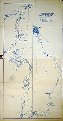
A map of Kingston to Ottawa, Ontario published by the National Development Bureau's Department of the Interior, circa 1930. The map features locks, bridges, waterways and settlements. Scale 2 miles to an inch. Written on the back, in ink, is "canoe trip." Presumably a tool of direction for someone's voyage.
Donated by the Belleville Public Library in 2014.
Canada. Department of the Interior