
Crown sale grant of land in Marmora Township
- 2022-039
- Item
- 1867
Province of Canada sale of Crown Lands (lot 15 in the fifth concession of Marmora Township) to John Fidlar, yeoman, of Marmora Township for $300.
Government of Canada
52 results directly related Exclude narrower terms
Crown sale grant of land in Marmora Township
Province of Canada sale of Crown Lands (lot 15 in the fifth concession of Marmora Township) to John Fidlar, yeoman, of Marmora Township for $300.
Government of Canada
Various notes and legal documents relating to Russell and Thomas Pitman of Thurlow Township, Hastings County. Partially transcribed by Lois Foster.
Pitman, Thomas
Deeds, maps and documents regarding mining properties in Lake and Tudor Townships
Deeds, maps and other documents relating to Thomas Ricketts' ownership of mining lands in Lake and Marmora Townships, Hastings County, Ontario.
Ricketts, Thomas
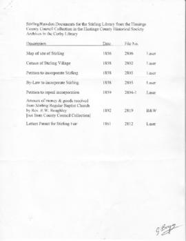
File of copies of documents relating to Stirling-Rawdon history
Part of Lewis Zandbergen collection
File of items relating to the founding of Stirling, Ontario, and to education in Stirling and Rawdon, copied from the holdings of the Hastings County Historical Society and the Archives of Ontario. These items were sent to Stirling Public Library by Gerry Boyce.
Boyce, Gerry
Part of Lewis Zandbergen collection
Various items related to Sidney Township, Hastings County, Ontario:
Microfiche of Archives of Ontario United Empire Loyalists Losses Enquiry and Land Record Index
Two sets of microfiche: Bureau of Archives 1904 printed report of United Empire Loyalists losses enquiry and Ontario Archives land record index of names.
Archives of Ontario
Deed relating to land on Bridge Street in Belleville, Ontario
Bargain and sale of part of lot 24 on the west side of Pinnacle Street and north side of Bridge Street in Belleville, Ontario from James Nosworthy, saddler and Harriet Clapham Nosworthy, his wife, to George Taylor of Sidney Township. Dated 7 May 1855.
County of Hastings
Grant from the Crown of 200 acres of land in Yonge Township, Leeds County (Concession 6, Lot 20) to Harriet Sherwood.
Sale of land in Northumberland County, Ontario
Bargain and sale of part of lot 17 in the second concession of Percy Township, Northumberland County, Ontario, sold by Joseph Sparrow to Thomas Arthur of Seymour East Township, 5 June 1846.
Deeds and plan relating to Pinnacle Playhouse site on Pinnacle Street in Belleville, Ontario
Deeds and papers relating to part of lot 28 on the west side of Pinnacle Street in Belleville, Ontario.
Dates and parties:
1) 18 Jan 1886: Francis Marskeel to William Bleecker
2) 10 Feb 1886: William Bleecker to Thomas Bales Coombs
3) 3 Sep 1889: Thomas Bales Coombs and Ellen Coombs to Thomas Henry Adams
4) 1 Jun 1891: Thomas Henry Adams and Jane Ann Adams to David Matthias Rees
5) 15 Jun 1892: David Matthias Rees and Ruth H. Rees to Herbert Henry Booth
6) 1 Jun 1896: Herbert Henry Booth and Cornelie Booth to Evangeline Cory Booth
7) 22 Nov 1904: Evangeline Cory Booth to Thomas Bales Coombs
8) 17 May 1910: Notice that the parcel of land is held in trust for the Salvation Army
9) 19 Mar 1926: Declaration by John Noble, Secretary of the Governing Council of the Salvation Army, Canada East, that the Salvation Army had held the parcel of land undisturbed since 22 Nov 1904.
10) 28 Dec 1939: Plan by Fraser Aylsworth, Ontario Land Surveyor, of the lot on which the Salvation Army Citadel (later the Pinnacle Playhouse) was located on Pinnacle Street in Belleville
Zoning plans of the City of Belleville
Two plans of Belleville (east and west) showing zoning categories for properties in the city, with lists of zoning by-law numbers and dates since 1977.
City of Belleville
Part of a deed for land in Hungerford Township
Lower half of a memorial recording the sale of Lot 17 in Concession 1 of Hungerford Township from David Gardiner of to Thomas Goldsmith Gardiner, all of Whitby, for £50. The deed is instrument 1488 in Book L of the Hastings County Land Registry Office.
Hastings County Land Registry Office

Photograph of Mike Stanko and Clare Homan
Photograph taken at John and Leatha Homan's farm on Harmony Road in Corbyville, Hastings County, Ontario. It shows Mike Stanko, a displaced person from Poland who came to Canada after the Second World War, and the Homan's son, Clare, next to a car.

Digital photographs of Mohawk blockade in support of Wet'suwet'en protest
Eleven digital photographs of the demonstration at the railway lines in the Tyendinaga Mohawk Territory in support of the Wet'suwet'en protest against the construction of the Coastal GasLink pipeline through their territory.
Morris, Bobby-Jo
Deeds and mortgages relating to Lot 20 on South King Street, Trenton
Deeds and mortgages for property on South King Street, Trenton. Individuals mentioned include Mary Booth, Clarissa Nugent, Charles D. Taft and George Frost
Hastings County Land Registry Office
Correspondence of John Brett McGeachie and copy of 'Bass Lake' book
Copy of McGeachie's book Bass Lake - Hastings County and correspondence between McGeachie and various authorities about the management of the McGeachie Conservation Area and his efforts to change the name of Steenburg Lake in Limerick Township, Hastings County, Ontario.
McGeachie, John Brett 'Jack'

"Indian Land Sale" Grant of land for Deseronto High School
Grant of three acres in Deseronto, Ontario, part of the territory of the Mohawks of the Bay of Quinte, to the Board of the Deseronto High School (John Newton, Frederick Sherwood Rathbun, Thomas Roach, Arthur Stanley Valleau, Herbert Burt Rathbun and Thomas Hamlin Nasmith), for the sum of $2,500. A stamp on the reverse of the deed states that it was registered on 12 May 1965.
Government of Canada
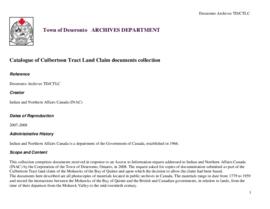
Culbertson Tract Land Claim collection
This collection comprises documents received in response to an Access to Information request addressed to Indian and Northern Affairs Canada (INAC) by the Corporation of the Town of Deseronto, Ontario, in 2008. The request asked for copies of documentation submitted as part of the Culbertson Tract land claim of the Mohawks of the Bay of Quinte and upon which the decision to allow the claim had been based.
The documents in this collection are all photocopies of materials located in public archives in Canada. The materials range in date from 1779 to 1959 and record the interactions between the Mohawks of the Bay of Quinte and the British and Canadian governments, in relation to lands, from the time of their departure from the Mohawk Valley to the mid-twentieth century.

A New Map of Upper & Lower Canada
Part of Map collection
A "New Map of Upper & Lower Canada" published December 1, 1807. Scale: British statute 69.5 miles to a degree. Created by John Cary, engraver and map-seller, No. 181 strand, London.
Cary, John

Part of Map collection
A map of the Dominion of Canada. Map dated 1927. Published by the Department of the Interior (Canada). Scale: 100 miles to 1 inch.
Canada. Department of the Interior