Canada

Taxonomy

Code

Scope note(s)

Source note(s)

Display note(s)

Equivalent terms

Canada

Associated terms

Canada

1281 Archival description results for Canada

56 results directly related Exclude narrower terms

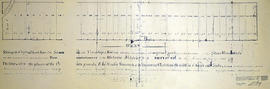
Map of Proposed bridge at mouth of the River Trent

A copy of an original map by N. H. Baird showing a harbour and bridge proposal at the Mouth of the River Trent - October 26, 1832.
Photocopied by the Archives of Ontario.

Baird, Nicol Hugh

Map of British North America

A reproduction by the Canadian Department of Energy, Mines and Resources of "British North America by Permission dedicated to The Honorable Hudsons Bay Company containing the latest information which their documents furnish by their obedient servants." The map was originally composed by John Arrowsmith in 1834.

Donated by Gerry Boyce.

Arrowsmith, John

Map of Upper Canada and United States

A map showing settlements of Upper Canada and part of the United States in 1834 by J. Arrowsmith.
Received from the Archives of Canada's map collection - July 9, 1971.

Arrowsmith, John

Parts of Ontario and USA in 1834

A map showing settlements of Ontario and part of the United States in February 1834 by J. Arrowsmith. The total area extends from Lake Huron East to Montreal and south Ohio to Long Island.
Received from the Archives of Canada's map collection - 11 May 1977.

Arrowsmith, John

Map of District of Prince Edward County

Map showing townships in the District of Prince Edward County: South Murray, Sidney, Thurlow, Ameliasburgh, Sophiasburgh. See boundary lines on map. Surveyed by Publius Virgillius Elmore, D.L.S. Dated 1835. Map copied from the Archives of Ontario.

Elmore, Publius Virgillius, D.P.S.

Map of Districts of Prince Edward and Midland

Map showing counties, townships, concessions and lots in the Districts of Prince Edward and Midland. Surveyed by Publius Virgillius Elmore, D.L.S. Published by Hallowell U.C. Dated 1836. Scale 160 chains : 1". Map copied from the Archives of Ontario.

Elmore, Publius Virgillius, D.P.S.

Plan of Sleeper Plot in Thurlow Township

A certified reproduction of the “Sleeper Plot.” A plan for a piece of land laid out for I. E. Sleeper on part of Lot # 5 in the First Concession of Thurlow Township, (now Belleville). The area contained includes; East of Moira River with Lots # 1 to 10 on both sides of the road to Canniffs Mills, Lot # 6, Concession 1 northerly to the line between Concession 1 and Concession 2, Thurlow Township. Originally surveyed by Samuel Benson, D. P. S. and produced on 18 Oct 1836. This copy was made July 30, 1980.

Benson, Samuel Manson, D.P.S. & P.L.S.

Plan of Diseronca (Deseronto)

1972 copy of an 1837 plan of 'Diseronca' (now Deseronto, Ontario), surveyed by G.J. Clapp on August 26th, 1837. The plan is Plan 43 of the plans registered in the Hastings County Registry.

The north-south streets shown on the right side of the map are, from right to left, First Street, Second Street, Third Street and Fourth Street. Near the end of Fourth Street a wharf is marked on the map. This is Culbertson's Wharf.

Clapp, Gilbert S. P.L.S.

Map of the Trent Port

Map showing a sketch of the Trent Port - June 12th, 1837. Scale: 2 chains to an inch. Published by the Office of the Surveyor General.

From the Archives of Ontario in Toronto.

Reproduction Map of Upper Canada East Part

A reproduction of a map of "Upper Canada East Part" by L. J. Herbert in January 1839. Scale in British miles. Published by the Lithographic Establishment Quarter, Master Generals Office.

Archives of Ontario

Map of Part of West side of Front Street

Map showing part of the West side of Front Street in Belleville, Ontario, c. 1845-50. By John J. Haslett, P.L.S. From the Archives of Ontario.

Haslett, John James, P.L.S. & D.P.S.

Boundary Lines Survey of Sidney Township, Con. 2

A certified reproduction of the “Boundary Line Commissioners Survey of the Second Concession of Sidney, for the Victoria District..” The area contained includes; Sidney Township, Concession 2, Lot Block A and Lots # 1 to 38. Originally surveyed by John Emerson, P. L. S. and produced on September 4, 1840. This reproduction was made on June 2, 1972 and approved by the Deputy Registrar.
Donated by Walter I. Watson, P. L. S.

Emerson, John, P.L.S.

Map of Canada, New Brunswick and C

A map of Canada, New Brunswick & C. The map covers Upper and Lower Canada, New Brunswick, Nova Scotia and Prince Edward Island. Published by Adam and Charles Black Co. of Edinburgh. Engraved by S. Hall for the 1840 edition of Black's General Atlas.

Adam and Charles Black Co.

Plan of Bridgewater in Elzevir Township

A certified reproduction of the “Plan of Bridgewater laid out on a part of Lots # 1, 2, and 3 in Concession 1, Elzevir Township. Surveyed for the proprietor Billa Flint..” The area contained includes; Bridgewater [now Actinolite] on the East bank of the Scootamata River on Lots # 1, 2, 3 in Concession 1, Township of Elzevir, along Hwy 37. Originally surveyed by John Emerson D. P. S. and produced circa 1840.

This reproduction was made on June 5, 1972 and approved by the Deputy Registrar.

Donated by Walter I. Watson, P. L. S.

Emerson, John, P.L.S.

Boundary Lines Survey of Sidney Township, Con. 5

A certified reproduction of the “Boundary Line Commissioners Survey of the Fifth Concession of Sidney, for the Victoria District.” The area contained includes; Concession 5, Lot Block A and Lots # 1 to 32. Originally surveyed by Samuel M. Benson, D. P. S. and produced on November 25, 1840.

This reproduction was made on June 5, 1972 and approved by the Deputy Registrar.

Donated by Walter I. Watson, P. L. S.

Benson, Samuel Manson, D.P.S. & P.L.S.

Boundary Lines Survey of Sidney Township, Con. 3

A certified reproduction of the “Boundary Line Commissioners Survey of the Third Concession of Sidney, for the Victoria District.” The area contained includes; Sidney Township, Concession 3, Lots: Block A and Lots # 1 to 38. Originally surveyed by John Emerson, P. L. S. and produced circa 1841. This reproduction was made on June 5, 1972 and approved by the Deputy Registrar.
Donated by Walter I. Watson, P. L. S.

Emerson, John, P.L.S.

Boundary Lines Survey of Thurlow

A certified reproduction of the “Boundary Line Commissioners Survey, Concession 1, Township of Thurlow, for the Victoria District.” The area contained includes; Thurlow Township, Concession 1, Lots # 5 to 31 and the Tyendinaga Mohawk Territory on the Southerly part of Lots # 28, 29, 30, 31 along the bayshore. Originally surveyed by John Emereson, P. L. S. and produced on December 27, 1841. This reproduction was made on June 5, 1972.

Donated by Walter I. Watson, P. L. S.

Emerson, John, P.L.S.

Boundary Lines Survey of Sidney Township, Con. 1

A certified reproduction of the “Boundary Line Commissioners Survey of Sidney Township. First Concession and Broken Front, for the Victoria District.” The area contained includes; Sidney Township, Concession 1 and the Broken Front Lots # 5 to 38. Originally surveyed by John Emereson, P. L. S. and produced on June 6, 1841. This reproduction was made by the Archives of Ontario.

Donated by Walter I. Watson, P. L. S.

Emerson, John, P.L.S.

Results 41 to 60 of 1281