Ontario

Taxonomía

Código

Nota(s) sobre el alcance

Nota(s) sobre el origen

Mostrar nota(s)

Términos jerárquicos

Ontario

Término General Canada

Ontario

Términos equivalentes

Ontario

Términos asociados

Ontario

88 Descripción archivística resultados para Ontario

24 resultados directamente relacionados Excluir términos relacionados

Postcards

Postcards. Some have writing on the back. Most don't. Most appear to be personal photos turned into postcards. Belfast,Ireland, Florida, USA, Quebec, Ontario, Tennessee, USA, Kingston, Ontario, Marmora, Ontario Hull, Quebec, Niagara, Ontario, Buffalo, USA, Stayner, Ontario etc.

Postcards

Postcards. Some have writing on the back. Most don't. Most appear to be personal photos turned into postcards. Belfast,Ireland, Florida, USA, Quebec, Ontario, Tennessee, USA, Kingston, Ontario, Marmora, Ontario Hull, Quebec, Niagara, Ontario, Buffalo, USA, Stayner, Ontario etc.

Postcards

Postcards. Some have writing on the back. Most don't. Most appear to be personal photos turned into postcards. Belfast,Ireland, Florida, USA, Quebec, Ontario, Tennessee, USA, Kingston, Ontario, Marmora, Ontario Hull, Quebec, Niagara, Ontario, Buffalo, USA, Stayner, Ontario etc.

Materials relating to the Kente Portage Heritage Conservation Society

  • CA ON00156 2020-068
  • Unidad documental compuesta
  • 1998-2020

File containing:

  1. 9 photographs of the construction of the restored Block House at Fort Kente in Carrying Place, 1998
  2. Photocopy of article by Paul Germain in Historic Kingston journal 'Rediscovering Kente', 1999
  3. Letter from Jane Beecroft to Paul Germain concerning a Trillium Foundation application relating to Fort Kente, 21 May 1999
  4. Article by Kente Portage Heritage Conservation Society on 320 year old documents, 1999
  5. Article by Mary-Lynne Morgan on the history of the Kente portage, 2020

Sin título

Road Map of the Province of Ontario 1956

  • CA ON00156 M/M400-1019
  • Unidad documental simple
  • 1956
  • Parte deMap collection

A road map of the northern and southern portions of the Province of Ontario. Published by the Ontario Department of Highways in 1956. Various indexes and legends are located on the map.

Sin título

Road Map of the Province of Ontario 1964

  • CA ON00156 M/M400-1022
  • Unidad documental simple
  • 1964
  • Parte deMap collection

A road map of the northern and southern portions of the Province of Ontario. Published by the Ontario Department of Highways in 1964. Various indexes and legends are located on the map.

Sin título

Road Map of the Province of Ontario 1967

  • CA ON00156 M/M400-1023
  • Unidad documental simple
  • 1967
  • Parte deMap collection

A road map of the northern and southern portions of the Province of Ontario. Published by the Ontario Department of Highways in 1967 for the Centennial Year. Various indexes and legends are located on the map.

Sin título

Map of the Great Lakes with French Missionary notes

  • CA ON00156 M/M400-2186
  • Unidad documental simple
  • 7 Jul 1882
  • Parte deMap collection

A map of Lake Ontario and the land surrounding it, with notes, presumably written by French explorers. Original date 1670, reprinted July 7, 1882.

Part of the Mika collection.

A Close Up of Southern Ontario, Ontario, and Canada

  • CA ON00156 M/M400-3036, 3038 - 3041, 3044/M400-3036
  • Unidad documental simple
  • Dec 1978
  • Parte deMap collection

A map entitled "A Close Up of Southern Ontario, Ontario, and Canada" by the National Geographic Society's Cartography Section. Scale: 1 centimeter = 30 kilometers or 1 inch = 47.3 miles. Dated December 1978.

Sin título

A Map of the Great Lakes

  • CA ON00156 M/M400-3036, 3038 - 3041, 3044/M400-3040
  • Unidad documental simple
  • Jul 1987
  • Parte deMap collection

A map showing the Great Lakes of Canada and the USA, by the National Geographic Society's Cartography Section. The totally area shown includes west Manitoba to east Quebec and north to Lake Nipigon and south to U. S. A. Scale: 1 centimeter = 23 kilometers or 1 inch = 36 miles. Dated July 1987.

Sin título

A Map of the Atlantic Gateways

  • CA ON00156 M/M400-3036, 3038 - 3041, 3044/M400-3041
  • Unidad documental simple
  • Mar 1983
  • Parte deMap collection

A map showing the gateways of the Atlantic Ocean in North America, by the National Geographic Society's Cartography Section. Scale: 1 centimeter = 13.2 kilometers or 1 inch= 20.8 miles. Dated March 1983.

Sin título

A Map of Canada, 1972

  • CA ON00156 M/M400-3036, 3038 - 3041, 3044/M400-3044
  • Unidad documental simple
  • Mar 1972
  • Parte deMap collection

A map of all of Canada, by the National Geographic Society's Cartography Section. Scale: 1;7460,000 or 117.7 miles to the inch. Dated March 1972.

Sin título

"Things to see and do in Ontario" Map

  • CA ON00156 M/M400-3045
  • Unidad documental simple
  • 1961
  • Parte deMap collection

A map of Ontario detailing sports and activities located within the "Heart of Canada - Ontario - [an] easy to reach vacation land!" The "things to see & do" are located at different stops along the Trans-Canada Highway. Map dated 1961. Published for free distribution by the Department of Travel & Publicity of the Province of Ontario.

Sin título

Road Map of Central Canada 1939

  • CA ON00156 M/M400-3046
  • Unidad documental simple
  • 1939
  • Parte deMap collection

A map of Central Canada detailing various roads, towns and cities. The total area extends from west Sarnia to east Prescott and north Algonquin Park to south Lake Ontario. Map dated 1939. Published by Imperial Oil Limited. Scale: 15 miles to 1 inch.

Sin título

Canadian National Railway System Map

  • CA ON00156 M/M400-3072
  • Unidad documental simple
  • 1952
  • Parte deMap collection

"The Only Railway Serving All Ten Provinces of Canada:" a map showing the Canadian National Railway System in 1952. The map includes: Canadian National Railways, Grand Trunk Western Railroad Company, Central Vermont Railway Inc., Duluth, Winnipeg and Pacific Railway Company. Composed by C.N.R. Montreal. Scale 10/16 of an inch to 50 miles.

Donated by Bruce Polmanter.

Sin título

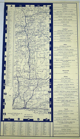
Townships of Hastings County with advertisements

  • CA ON00156 M/M420-1104
  • Unidad documental simple
  • 1932
  • Parte deMap collection

A map of Hastings County, in 1932, showing lakes, rivers, cities, towns and townships. A list of businesses within the county are on the right. Drawn exclusively for and published by Croydon Publishing Company.

Sin título

Road Map of Hastings County 1932

  • CA ON00156 M/M420-1105
  • Unidad documental simple
  • 1932
  • Parte deMap collection

A road map of Hastings County in 1932. Portions of adjoining counties are also pictured. Boundaries are yellow, while roads are blue and red. Published by the Ontario Department of Highways. Scale: 1 inch = 4 miles. Dimensions: 40.7cm x 66cm.

Sin título

Road Map of Hastings County 1953

  • CA ON00156 M/M420-1110
  • Unidad documental simple
  • 1953
  • Parte deMap collection

A road map of Hastings County in 1953. Portions of adjoining counties are also pictured. Boundaries are yellow, while roads are blue and red. Published by the Ontario Department of Highways. Scale: 1 inch = 4 miles.

Sin título

Road Map of Hastings County 1956

  • CA ON00156 M/M420-1111
  • Unidad documental simple
  • 1956
  • Parte deMap collection

A road map of Hastings County in 1956. Portions of adjoining counties are also pictured. Boundaries are yellow, while roads are blue and red. Published by the Ontario Department of Highways. Scale: 1 inch = 4 miles. Dimensions: 72cm x 46.5cm.

Donated by Vera Crabbe in 2008.

Sin título

Resultados 1 a 20 de 88