
The Belleville Directory for 1877
- CA ON00156 CH/13/1/4
- Item
- 1877
Parte de County of Hastings records
Digital copy of Hoogs & Milette's 1877 directory of Belleville, Napanee, Trenton, and Brighton.
40 resultados diretamente relacionados Excluir termos específicos
The Belleville Directory for 1877
Parte de County of Hastings records
Digital copy of Hoogs & Milette's 1877 directory of Belleville, Napanee, Trenton, and Brighton.
Ontario Hydro Aerial Plan of Lots 23-26 in Cramahe
Parte de Map collection
Plan showing Cramahe Township, Northumberland County, Concession 8, Lots # 23 to 26 part of road allowance between Lots # 22 & 23, Concession 8 (Map # TD24778Z). For Ontario Hydro Transmission & Distribution projects, Division Orthophoto Title Study. Scale: 1 inch= 200 feet.
Sem título
Ontario Hydro Aerial Plan of Lots 27-31 in Cramahe
Parte de Map collection
Plan showing Cramahe Township, Northumberland County, Concession 8, part Lots # 27 to 31. Aerial View of Ontario Hydro Project. (Map # TD24779Z). For Ontario Hydro Transmission & Distribution projects, Division Orthophoto Title Study. Scale: 1 inch= 200 feet.
Sem título
Ontario Hydro Aerial Plan of Lots 32-35 in Cramahe
Parte de Map collection
Plan showing Cramahe Township, Northumberland County, Concession 8, Part Lots # 32 to 35 (Map # TD24780Z). For Ontario Hydro Transmission & Distribution projects, Division Orthophoto Title Study. Scale: 1 inch= 200 feet.
Sem título
Aerial Photograph of Hamilton and Hope Townships
Parte de Map collection
Hamilton & Hope Townships, Map (order) 841-5711 showing areas of; Hamilton & Hope Townships-including Cobourg & Port Hope showing Hydro lines and gas & oil pipelines. Dated August 27, 1973. Scale: 1 inch = 2000 feet.

Hydro-Electric Power Commission of Ontario, Frankford Section
Parte de Map collection
An original map produced for the Hydro-Electric Power Commission of Ontario, concerning hydro power lines, stations and transformers. However, the map also features railways, roads and land boundaries.
This map is of the North Section - Frankford Rural Power District. The total area includes parts of Thurlow, Huntingdon, Sidney, Rawdon, Campbellford, Seymour, Brighton, and Percy Townships. Circa 1950.
Donated by David Pershik.
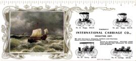
Brighton - International Carriage Co. 1880
File contains a printed promotional blotter for the International Carriage Co., Brighton.
Brighton - Flood - 1852 : "the lake that broke away"
File contains contains a newspaper clipping on the Brighton Township flood of 1859.
Movies : Quinte District film making
Parte de HCHS Textual Records collection: Files 2000 to 2499
File contains a newspaper article from The Intelligencer, 28 June 1968, concerning the filming of 'The End' a short production concerning World War II, which was shot in Campbellford, Ontario.
Parte de HCHS Textual Records collection: Files 2000 to 2499
File contains printed maps and drawings of the Murray Canal site. Also present is a printed document entitled “A paper on the proposed Murray Canal Between Lake Ontario and the Bay of Quinte...for use of Members of the Senate and House of Commons,” February, 1880; a printed excerpt from the Annual Report of the Public Works Department, 1891 regarding the Murray Canal; and correspondence from the Department of Mines and Technical Surveys, to Thomas S. Ransom, Ontario Land Surveyor, dated 11 April 1967 pertaining to the construction and administration of the canal from 1882 to 1967.
Murray Township : surveyor's notes
Parte de HCHS Textual Records collection: Files 2000 to 2499
File contains manuscript field notes of an 1884 survey of the Trent River in the Township of Murray in the Newcastle District by Provincial Land Surveyor, F.P. Rubidge.
WW1 Discharge Certificate - Clarke, Robert Clifford
Parte de HCHS Textual Records collection: Files 3000 to 3499
Photo of Discharge Certificate from the Canadian Expeditionary Force, Cobourg Heavy Battery for Robert Clifford Clarke dated 26-May-1917.

Plans for COR Station at Cobourg
Parte de Map collection
A blueprint of the proposed new railway station, restaurant etc. at Cobourg, Ontario. Drawn by John Dunlop Evans, Chief Engineer. Published by the Office of Master of Bridges and Buildings G.T.R. in April 1911.
Sem título
Alternative Hydro Routes from Lennox to Oshawa
Parte de Map collection
A map studying alternative routes for hydroelectric power. The area covers from West Oshawa, East Mount Pleasant Jct. North Rice Lake & South Lake Ontario.
Sem título
Map 3 from the Hydro Comission Route Inquiry
Parte de Map collection
A map studying the proposed routes for power transmission from Lennox to Oshawa. The area covers from West Oshawa, East Mount Pleasant Jct. North Rice Lake & South Lake Ontario.
Sem título
Trent Canal : “Report on the Most Eligible Route” 1855 / N. H. Baird
Parte de HCHS Textual Records collection: Files 2500 to 2999
File contains a printed booklet entitled “Report on the most eligible route for a canal between Lake Simcoe ..and Georgian Bay...to the Bay of Quinte...” by N.H. Baird, C.E., published at Belleville in 1855. The report discusses proposed routes for a Trent-Severn Canal project.
Topographical map of Campbellford - west half
Parte de Map collection
A topographical map of Campbellford - Canada sheet #31 C/5. Published by the Army Survey Establishment, Department of National Defence in 1956. Scale 1:50,000.
Sem título
Topographical map of Port Hope
Parte de Map collection
A topographical map of Port Hope - Canada sheet #30 M/16. Published by the Army Survey Establishment, Department of National Defence in 1938. Scale 1 inch to 1 mile = 1/63, 360.
Sem título
Topographical map of Presqu'ile - east half
Parte de Map collection
A topographical map of Presqu'ile - Canada sheet #30 N/13, east half. Published by the Army Survey Establishment, Department of National Defence in 1951. Scale 1:50,000.
Sem título

Parte de County of Hastings records
Digital copy of 1893 Union Publishing Company's directory of the Counties of Durham, Hastings, Lennox, Addington, Northumberland, Prince Edward