
- CA ON00156 BOHP/2
- Dossier
- 18 October 1974
Fait partie de Belleville Oral History Project transcripts
Captain Jack Buchanan describes his childhood in Wales, immigration to Canada and his life on the Great Lakes freighters.
Sans titre
Fait partie de Belleville Oral History Project transcripts
Captain Jack Buchanan describes his childhood in Wales, immigration to Canada and his life on the Great Lakes freighters.
Sans titre

Photograph taken outside the Brotherhood of Locomotive Engineers Hall of members of the Order of Railway Conductors and Brotherhood of Railway Trainmen involved in the Grand Trunk Railway Strike of July 18 to August 2, 1910.
Sans titre

Schedule of activities held in Belleville, Ontario during Railway Week, June 22-28, 1964. Includes photographs of locomotives. "Debbie Wade 1964" is written in ink on the front cover.
Sans titre
Hydro-Electric Power Commission of Ontario, Tweed-Section
Fait partie de Map collection
An original map produced for the Hydro-Electric Power Commission of Ontario, concerning hydro power lines, stations and transformers. However, the map also features railways, roads and land boundaries.
This map is the West Centre Section - Tweed ROA. The total area includes parts of Rawdon, Marmora, Huntingdon, Madoc, Hungerford, and Elzevir Townships. Dated October 16, 1951. Scale: 1.2 inches = 1 m.
Donated by David Pershik.

Hydro-Electric Power Commission of Ontario, Frankford Section
Fait partie de Map collection
An original map produced for the Hydro-Electric Power Commission of Ontario, concerning hydro power lines, stations and transformers. However, the map also features railways, roads and land boundaries.
This map is of the North Section - Frankford Rural Power District. The total area includes parts of Thurlow, Huntingdon, Sidney, Rawdon, Campbellford, Seymour, Brighton, and Percy Townships. Circa 1950.
Donated by David Pershik.
Hydro-Electric Power Commission of Ontario, Tweed Section
Fait partie de Map collection
An original map produced for the Hydro-Electric Power Commission of Ontario, concerning hydro power lines, stations and transformers. However, the map also features railways, roads and land boundaries.
This map is of the Southwest Section - Tweed Rural Power District. The total area includes parts of Hungerford, Huntingdon, and Thurlow Townships. Dated October 16, 1951. Scale: 2 inches = 1 mile.
Donated by David Pershik.

Seymour Power & Electric Co. Limited in Murray Township
Fait partie de Map collection
An original map produced for the Seymour Power & Electric Co. Limited, concerning proposed transmission lines within the Township of Murray. However, the map also features railways, roads, mills and land boundaries. Circa 1910. Scale: 50 chains = 1 inch. Map composed by Smith, Kerry and Chace Engineers located in Toronto, Winnipeg, Calgary and Vancouver.
Donated by David Pershick.
Sans titre

Trenton Electric & Water Co. Limited in Sidney Township
Fait partie de Map collection
An original map produced for the Trenton Electric & Water Co. Limited, concerning proposed transmission lines within the Township of Sidney. However, the map also features railways, roads and land boundaries. Circa 1910. Scale: 50 chains = 1 inch. Map composed by Smith, Kerry and Chace Engineers located in Toronto, Winnipeg, Calgary and Vancouver.
Donated by David Pershick.
Sans titre

Fleming family collection of Ivanhoe materials
Sans titre

Digital copy of photograph of the steamer Brockville
Scanned copy of a photograph of the steamship Brockville at the wharf of the Ontario School for the Deaf in Belleville, Ontario.

Slides of Belleville and Ontario scenes
Slides made by Rudolf Donninger during his time in Belleville, Ontario, working at Northern Electric. They include photographs of buildings in Belleville, rural scenes, cars, a parade and the Belleville Fair in 1970, winter scenes, Ottawa and Kingston views, and aircraft at the Trenton Air Show.
Sans titre

Fait partie de HCHS Textual Records collection: Files 1 to 999
File contains two 1960 newspaper clippings looking back to May 6th and 7th, 1910 with news of the Carman Opera House and purchasers of cars.

Business card for George Hoggard
Fait partie de HCHS Textual Records collection: Files 3000 to 3499
Business card reading:
Anglo-American, Front Street, Belleville
George Hoggard, Proprietor
Strict Attention Given to Travellers
The Best $1.00 a Day House in the City.
Street Cars pass the Door every 15 Minutes. Stages Call for All Parts.
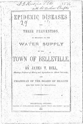
Epidemic Diseases and their Prevention in relation to the Water Supply of the Town of Belleville
Fait partie de HCHS Textual Records collection: Files 3000 to 3499
Photocopy of a publication by James T. Bell, professor of mining and agriculture in Albert University and Chairman of the Board of Health for the Town of Belleville.
Sans titre

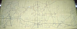
Map of Hastings County and Road Changes
Fait partie de Map collection
A map of Hastings County in 1914. Roads to be removed are highlighted in red colour. Published by the Office of Public Roads and Highways. Scale: 2 miles = 1". Dimensions: 54cm x 87cm.
Donated by Eric Jones, accession #2015-49.
Sans titre

Map of Town Plot at mouth of Trent River
Fait partie de Map collection
A map of a town plot at the mouth of the Trent River in the Newcastle District. The map features numbered lots, present streets and water ways. Scale: 1 inch = 2 chains. Originally surveyed by F. P. Rubidge, D.P.S., in 1834. This copy was issued September 23, 1926.
Sans titre

Floor Plans for COR CPR Union Station at Trenton
Fait partie de Map collection
A blueprint planning the floor of the COR and CPR Union Station at Trenton, Hastings County, Ontario. Drawn by John Dunlop Evans, Chief Surveyor/Engineer - August 23, 1897.
Sans titre

Plans for COR Station at Cobourg
Fait partie de Map collection
A blueprint of the proposed new railway station, restaurant etc. at Cobourg, Ontario. Drawn by John Dunlop Evans, Chief Engineer. Published by the Office of Master of Bridges and Buildings G.T.R. in April 1911.
Sans titre

Canadian National Railway System Map
Fait partie de Map collection
"The Only Railway Serving All Ten Provinces of Canada:" a map showing the Canadian National Railway System in 1952. The map includes: Canadian National Railways, Grand Trunk Western Railroad Company, Central Vermont Railway Inc., Duluth, Winnipeg and Pacific Railway Company. Composed by C.N.R. Montreal. Scale 10/16 of an inch to 50 miles.
Donated by Bruce Polmanter.
Sans titre
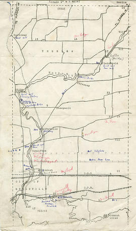
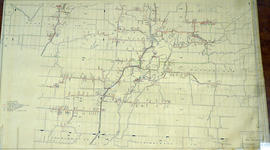
Map of Thurlow Township with annotations
Fait partie de Map collection
A map of Thurlow Township featuring the addition of handwritten annotations. Concessions, railways, proprietors, businesses and locations are featured. The map extends from the Bay of Quinte in the southwest to Roslin the northeast. Circa 1950 (Bakelite plant opened c. 1948 and the Foxboro Cheese Factory closed in 1961).
Specific annotations are as follows: Halloway Grist Mill, Latta Bridge, Plainfield Grist, Saw Mill, O'Brien's Bridge, Grist Mill, Canning Factory Foxboro, Footbridge, Cheese Factory, Fairfields Bridge, Dam Corbyville, Distillery, Cannifton Dam, Grist & Saw Mill, Quarry & Substation, Round House, Brickyard, Graham's Dried Foods, Bell Telephone Lines, Hydro Power Lines, and Cement Works.