Scanned image of a photograph of the house at 153 Victoria Avenue, Belleville, Ontario. The house was built by Charles Frederick Smith in around 1878 and sold by Smith to John Wesley Johnson in 1889 for $4,250. Johnson was the Principal of the Ontario Business College in Belleville and Mayor of Belleville, 1897-1900, and Member of the Provincial Parliament for Hastings West, 1908-1919.
Hastings County Historical Society. Building Research Committee
Nineteen photographs of the Norris Whitney bridge between Belleville and Rossmore, Ontario, under construction. Three were taken from the air when Ross Cummings was flying a Cessna 150 over the bridge.
Photographs of Deseronto, Ontario dating from the 1970s to 2011, depicting a variety of Town events. They include a set of aerial photographs of the town from the 1980s; the interior of the former Home Hardware store in the Baker Block on Main Street; the O’Connor House on Main Street before its demolition; the 1989 100th Anniversary celebrations, photographs of Centennial Park and Rathbun Memorial Park; the opening of the Deseronto Public Library in its 358 Main Street location in 2001; the Ontario Provincial Police handover ceremony in 2001; an Easter Parade from the early 2000s; a Santa Parade; the 2002 New Year’s Levee; and the 2010 Olympic Flame run in Deseronto.
Most of the photographs appear to have been taken by Town staff. One envelope was donated to the Town by Irene Usher and contains photographs taken by her late husband, Tom.
Sign reading 'Schryver's' from former Schryver drugstore at 214 Front Street, Belleville, Ontario. City directories place this business at this location from 1959 to 1964.
Slides made by Rudolf Donninger during his time in Belleville, Ontario, working at Northern Electric. They include photographs of buildings in Belleville, rural scenes, cars, a parade and the Belleville Fair in 1970, winter scenes, Ottawa and Kingston views, and aircraft at the Trenton Air Show.
File contains 18 negatives of Belleville, Ontario buildings (mainly on Front Street: Woodley furs, the Belmont Restaurant, Whalen music) and copies of Lois Foster's notes on the early history of downtown buildings.
A copy of a map planning streets and some buildings in Belleville, Ontario, 1864-65. Composed by R. L. Innes, ESQ. C.E. Produced for the Hastings Directory.
A 1972 copy of a "Plan of the Town of Belleville, as laid out in subdivisions - A.D. 1868." City lots, wards and street names are identified on the map. Surveyed by John J. Haslett, P.L.S.
A map showing, primarily, the depth of the Moira River within Belleville, Ontario. Together with a written report, it proposed a channel to the New Ferry Slip. Major streets and some lots are also labelled. By John D. Evans, P.L.S. on April 28, 1881 or 1887. Scale: 66 feet : 1". Note the interesting colouring at dimmed edges.
A copy of a map detailing the temporal and spatial sequence of Belleville's growth from a village to a town and then a city. The different stages of growth (see legend) and administrative boundaries are outlined. Created by the Belleville and Suburban Planning Board in July 1967.
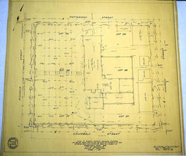
A "Plan of Survey showing Physical Features" detailing city lots, buildings and streets in Belleville. Ontario. By John T. Ransom, Ontario Land Surveyor on January 8, 1959 and revised on March 23, 1959. Scale: 1 inch to 20 feet.
Text: [based on the] Government Plan 1816; [including] Lots # 28 and part of Lots # 27 and 29 East of Pinnacle Street and Lot # 28 and part of Lots # 27 and 29 West of Church Street.
Donated by Tom Ransom, Belleville, surveyor and son of the author.
A pre-1900 map of the Sampson Ward in Belleville, Ontario. Streets and lots are outlined and named, as well as the Bay of Quinte. Scale: 1" = 3 chains.
A Map of the City of Belleville, Ontario. The developed streets are pictured alongside their names. Local water ways including the Bay of Quinte and the Moira River are also present. Composed by Charles A. Mott and published by the City Engineers Office. Circa 1950.
A map of the City of Belleville showing planned usage of the land - see legend for the different uses. Composed by Charles A. Mott and published by the City Engineers Office. Dated January 1949. Scale 1:8000.