
- CA ON00156 TR/0924-1
- Dossier
- 1961
Fait partie de HCHS Textual Records collection: Files 1 to 999
File contains a newspaper clipping about the reforestation of the Corby Distillery farm.
Fait partie de HCHS Textual Records collection: Files 1 to 999
File contains a newspaper clipping about the reforestation of the Corby Distillery farm.

Fait partie de Map collection
A map showing concessions and lots of Huntingdon - Madoc Township, Hastings County. Circa 1869. 30 advertisements for companies surround the map. Published by Macleod and Carre, Engineers and Surveyors. Scale: 1:63,000. Dimensions: 34.0cm x 37.0cm. Map was created from Government plan.
Donated from the Col. W. N. Ponton Estate. Penciled notes on map show Ponton family's interest in mining, especially after the Eldorado Gold Rush in 1866.
Sans titre

Map of Railway Station, Harbour and Wharf Facilities
Fait partie de Map collection
A map detailing the Grand Trunk Railway's station (1882), harbour and wharf facilities (1878) in Belleville, Ontario. Legends on each side of the maps describe buildings and areas. By William Michaud.
Sans titre

Carre's Plan of the city of Belleville 1892
Fait partie de Map collection
A copy of a map planning streets and buildings in Belleville, Ontario, 1892. The total area extends from Belleville to Bay of Quinte to Bridge Street (sheet 2) and from Bridge Street to Concession Road Allowance - now College Street - (sheet 1). Surveyed by Henry Carre, Ontario Land Surveyor.
Scale: 10 chains to an inch.
Sans titre

Aerial View of Quinte Cruising Waters
Fait partie de Map collection
A reproduction of a pre-1949 aerial view photo located in a tourism advertisement book. The booklet advertises Quinte's cruising waters extending from Trenton to Adolphus Reach.
Sans titre
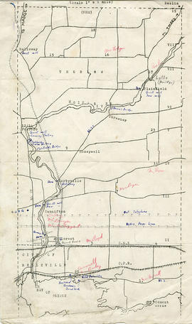
Map of Thurlow Township with annotations
Fait partie de Map collection
A map of Thurlow Township featuring the addition of handwritten annotations. Concessions, railways, proprietors, businesses and locations are featured. The map extends from the Bay of Quinte in the southwest to Roslin the northeast. Circa 1950 (Bakelite plant opened c. 1948 and the Foxboro Cheese Factory closed in 1961).
Specific annotations are as follows: Halloway Grist Mill, Latta Bridge, Plainfield Grist, Saw Mill, O'Brien's Bridge, Grist Mill, Canning Factory Foxboro, Footbridge, Cheese Factory, Fairfields Bridge, Dam Corbyville, Distillery, Cannifton Dam, Grist & Saw Mill, Quarry & Substation, Round House, Brickyard, Graham's Dried Foods, Bell Telephone Lines, Hydro Power Lines, and Cement Works.
Plot Plan in the City of Belleville in 1960
Fait partie de Map collection
A plan of a plot in the City of Belleville. Some of the buildings on site include Zellers, A and P, Reitmans. The plot is located between Dundas Street and Bridge Street. Published December 30, 1960 by Principal Investments Ltd., General Contractors.
Donated by the Belleville Public Library in 2014.

Dominion of Canada with Hudson's Bay areas
Fait partie de Map collection
A Map of the Dominion of Canada Shewing the Establishments of the Hudson's Bay Company. Scale: 1:10,500,00. Note the presence of the Districts of Mackenzie, Keewatin and Franklin and the border of Manitoba - circa 1905.

Jones, Mrs. Eliza, Deed of Land, Eliza Wife of Rev. Sept. Jones 1868
Fait partie de HCHS Textual Records collection: Files 1500 to 1999
File contains a Deed of Land Sale between Agnes Fitzgibbon of Toronto and Eliza Jones of lots one and two on Bridge Street in Belleville, Ontario.
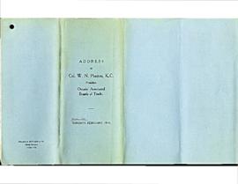
Ponton, W.N. : address as President of Ont. Associated Boards of Trade, February 24, 1914
Fait partie de HCHS Textual Records collection: Files 2500 to 2999
File contains a typescript transcript of a presidential address by William Nisbet Ponton, President of the Ontario Associated Board of Trades, 24 February 1914, concerning economic indicators, development and investment in Ontario.
Sans titre

Post Offices - Tyendinaga, Shannonville, Deseronto
Fait partie de HCHS Textual Records collection: Files 2500 to 2999
File contains a list of Postmasters names and dates of service for: Shannonville, Deseronto, Melrose, Lonsdale, Albert, Naphan, Marysville, Read, Kingsford, Blessington and Halston Post Offices.

Business card for George Hoggard
Fait partie de HCHS Textual Records collection: Files 3000 to 3499
Business card reading:
Anglo-American, Front Street, Belleville
George Hoggard, Proprietor
Strict Attention Given to Travellers
The Best $1.00 a Day House in the City.
Street Cars pass the Door every 15 Minutes. Stages Call for All Parts.

Fait partie de Belleville Oral History Project transcripts
Bryson Leslie discusses selling shoes from Leslie's Shoe Store, the flood of 1936 in Belleville and the establishment of a ski shop in Belleville.
Sans titre

Reproduction of R. G. Dun Mercantile Agency Reference Book for Hastings County, 1902
Fait partie de County of Hastings records
Photocopy of a 1902 directory of businesses in Hastings County.

Fait partie de Hastings County Historical Society Brochure collection
A promotional brochure for the City of Belleville, featuring local businesses and business people.
Sans titre

Fait partie de Hastings County Historical Society Brochure collection
Brochure produced by the City of Belleville, featuring businesses, homes and activities in the Belleville and Quinte area of Ontario.
Sans titre

Nichols, Margaret Joy Fletcher
Fait partie de Belleville Oral History Project transcripts
Margaret Nichols discusses running the Quinte Book Shop in Belleville, and downtown Belleville.
Sans titre

Photograph of employees of the Stephens-Adamson plant, Franklin Street, Belleville
Panoramic photograph of employees of the Stephens-Adamson Manufacturing Company of Canada Limited, Franklin Street, Belleville, Ontario. Taken 1 June 1943.

Materials collected by Arthur Tufts (father of Marilyn Hughes), including:
Sans titre

Trenton Electric & Water Co. Limited in Thurlow Township
Fait partie de Map collection
An original map produced for the Trenton Electric & Water Co. Limited, concerning their water mains, towers and substations within the Township of Thurlow. However, the map also features railways, roads and land boundaries. Circa 1910. Scale: 50 chains = 1 inch. Map composed by Smith, Kerry and Chace Engineers located in Toronto, Winnipeg, Calgary and Vancouver.
Donated by David Pershick.
Sans titre