Belleville Transit Rider Guide and Schedule 2015
- CA ON00156 M/M440/1823
- Item
- 2015
Parte de Map collection
A map featuring the transit routes, street routes and rider fares for the Belleville Bus Transit system.
Sem título
398 resultados diretamente relacionados Excluir termos específicos
Belleville Transit Rider Guide and Schedule 2015
Parte de Map collection
A map featuring the transit routes, street routes and rider fares for the Belleville Bus Transit system.
Sem título
Belleville Transit Rider Guide and Schedule 1979
Parte de Map collection
A map featuring the transit routes, street routes and rider fares for the Belleville Bus Transit system.
Sem título
Belleville Transit Rider Guide and Schedule 2018
Parte de Map collection
A map featuring the transit routes, street routes and rider fares for the Belleville Bus Transit system.
Sem título
Belleville Transit Rider Guide and Schedule 2017
Parte de Map collection
A map featuring the transit routes, street routes and rider fares for the Belleville Bus Transit system.
Sem título
Belleville Transit Rider Guide and Schedule 2016
Parte de Map collection
A map featuring the transit routes, street routes and rider fares for the Belleville Bus Transit system.
Sem título
Belleville Transit Rider Guide and Schedule 2010
Parte de Map collection
A map featuring the transit routes, street routes and rider fares for the Belleville Bus Transit system.
Sem título
Election Canada Advance Polling Stations in Belleville
Parte de Map collection
A reproduced map detailing advance electoral polling stations within the City of Belleville. The map includes Bayview Mall, Fire Dept Training Office and St. Mark's United Church as stations, wards and boundaries.
Sem título
Parte de Map collection
An aerial photograph of Napanee (Map # 49C4709/70). Map includes: Napanee River and Village in the Townships of South & North Fredericksburg. A small part of Ernestown & Camden Townships. Concession 1 to 5 of Richmond Township, Deseronto and Hay Bay Circa 1970. Scale: 1:2,000.
Map includes Trans-Northern Pipeline and Trans Canada Pipeline and the Hydro Lines. Donated by Walter I. Watson, P. L. S.
Aerial Photograph of Belleville
Parte de Map collection
Belleville, Map # 78-4413-24 showing areas of; North East Belleville, Alemite Park on South West corner of map, Moira Secondary School near South East corner of map and Leeming Farm on 3rd Concession Road at North side of map. Published by the Ministry of Natural Resources. Surveyed by Walter I. Watson, P.L.S. Circa 1970.
Sem título

South and Central Hastings Map
Parte de Map collection
"Cummins Rural Directory Map:" A map of South and Central Hastings, in 1923, featuring post offices, hamlets and lot owners. Map is surrounded by advertisements. Published by Cummins Map Co., Toronto. Dimensions 71cm x 50.5cm.
Sem título

Plan 204 - Brown Block, Belleville, Ontario
Parte de Map collection
Copy of plan 204 registered in the Hastings County Land Registry Office, showing the Brown Block between Sidney Street (Townline Street) and Wilkins Street in Belleville, Ontario. The plan was drawn up by Evans and Bolger for James W. Brown, a tailor.
Sem título

Plan of the town of Belleville 1864-65
Parte de Map collection
A copy of a map planning streets and some buildings in Belleville, Ontario, 1864-65. Composed by R. L. Innes, ESQ. C.E. Produced for the Hastings Directory.
Scale: 10 chains to an inch.

Haslett's 1868 Plan of Belleville
Parte de Map collection
A 1972 copy of a "Plan of the Town of Belleville, as laid out in subdivisions - A.D. 1868." City lots, wards and street names are identified on the map. Surveyed by John J. Haslett, P.L.S.
Sem título
Map of Part of West side of Front Street
Parte de Map collection
Map showing part of the West side of Front Street in Belleville, Ontario, c. 1845-50. By John J. Haslett, P.L.S. From the Archives of Ontario.
Sem título

Map of Railway Station, Harbour and Wharf Facilities
Parte de Map collection
A map detailing the Grand Trunk Railway's station (1882), harbour and wharf facilities (1878) in Belleville, Ontario. Legends on each side of the maps describe buildings and areas. By William Michaud.
Sem título

Belleville and Bay of Quinte depth chart
Parte de Map collection
Reproduction made in 1976 of an 1875 map of the Belleville Harbour in Bay of Quinte. The map features major streets, buildings and depth readings of travelled waters. Surveyed by F. M. Hamel, C.E. Drawn by J. M. Faga. Scale: 1:6000.
Sem título
Teacher's Guide to Quinte in 1785
Parte de Map collection
Map showing the Bay of Quinte to Presqu'ile to the eastern tip of Grande Isle (Wolfe Island) used as a teacher's guide to the area in 1785. The 20th century names are in capital letters as per the Legend.

Depth of the Moira River for Channel Plan
Parte de Map collection
A map showing, primarily, the depth of the Moira River within Belleville, Ontario. Together with a written report, it proposed a channel to the New Ferry Slip. Major streets and some lots are also labelled. By John D. Evans, P.L.S. on April 28, 1881 or 1887. Scale: 66 feet : 1". Note the interesting colouring at dimmed edges.
Donated by the Col W. N. Ponton Estate.
Sem título

Map of Belleville's Growth from 1816-1965
Parte de Map collection
A copy of a map detailing the temporal and spatial sequence of Belleville's growth from a village to a town and then a city. The different stages of growth (see legend) and administrative boundaries are outlined. Created by the Belleville and Suburban Planning Board in July 1967.
Sem título
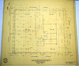
Survey Plan and Physical Features of Belleville
Parte de Map collection
A "Plan of Survey showing Physical Features" detailing city lots, buildings and streets in Belleville. Ontario. By John T. Ransom, Ontario Land Surveyor on January 8, 1959 and revised on March 23, 1959. Scale: 1 inch to 20 feet.
Text: [based on the] Government Plan 1816; [including] Lots # 28 and part of Lots # 27 and 29 East of Pinnacle Street and Lot # 28 and part of Lots # 27 and 29 West of Church Street.
Donated by Tom Ransom, Belleville, surveyor and son of the author.
Sem título