Poor reproduction of a sketch of Upper Canada to show places designated by Lt. Gov. Simcoe for towns and proposed military roads, circa 1796. The map was published by B. M. Kings.
Reproduction of a map showing "the Routes Lt. Gov. J. G. Simcoe took on trips" throughout Upper Canada from March 1792 to September 1795. The map was charted by Lt. Gov. Simcoe. A good depiction of the area now referred to as Southern Ontario and his plans for a capital there - "London." This map was published as part of "Charting Our Past" from the Archives of Ontario by Stonehouse Publications.
A map showing the 37 polling subdivisions of Belleville, Hastings County, Ontario. Composed by Charles Mott from the City in August 1958 and published in The Ontario Intelligencer on 28 November 1958.
Reproduction of a map showing new settlements, townships, counties etc.in the province of Upper Canada as of April 12, 1800. The total area spans from Quebec to Lake Huron and from Lake Michigan to New Hampshire then south to Pennsylvania in the U.S.A. This was the first printed map of Upper Canada, showing all settlements since 1784. Charted by D. W. Smith, Esq., Surveyor General London and published by W. Faden.
This map was published by Stonehouse Productions as part of "Charting Our Past" from the Archives of Ontario.
Reproduction of a map showing regions within "Canada West, formerly Upper Canada " 1850. The map is divided in 3 parts: Canada West formerly Upper Canada, part 2 Vicinity of the Falls of Niagara and part 3 The City of Toronto and its environs. In 1849, the County succeeded the District as the division for municipal and judicial purposes in Canada West. That along with recent transportation developments. Composed and published by Thomas Cowperthwaite & Co. in the Clerk Office of the District Court of the Eastern District of Pennsylvania.
This map was published by Stonehouse Productions as part of "Charting Our Past" from the Archives of Ontario.
Reproduction of a map showing regions of the western part of the province of Canada, in 1865. It features transportation and urban developments two years before Confederation, along with increased knowledge of the topography in northern regions, particularly in Canada East. Elevations are given for the Huron and Ottawa territory. Composed by Keith Johnston F. R. S. E. Published by W. & A. K. Johnston Edinburgh.
This map was published by Stonehouse Productions as part of "Charting Our Past" from the Archives of Ontario.
A series of topographical maps of Hastings County and the surrounding area, published by the Army Survey Establishment - National Department of Defence from the 1930s - 1950s.
A reproduction of part of a map showing Lower Canada, Quebec and Ontario in 1825. Map shows bodies of water and names of settlements. The boundary of Lower Canada is according to a treaty with the United States. From the Archives of Canada on July 27, 1966. Donated by Chewett.
Reproduction of Part 2 of a map showing a plan of the Principal Settlements of Upper Canada in 1817. The area covers from Northumberland to Essex counties. This map can be found the Archives of Canada.
Reproduction of Part 1 of a map showing a plan of the Principal Settlements of Upper Canada in 1817. The area covers from Eastern to Midland to Home District. This map can be found the Archives of Canada.
A "Map of Canada - Exclusive of Northern Regions - Indicating Main Natural Resources." Map revised in 1936. Published by the Department of Mines & Resources (Canada). Scale: 100 miles to 1 inch.
A Floor Plan of the Main First Floor at the County Court House on Pinnacle Street in Belleville, Ontario. All rooms and areas are named: Turnkey's Apartment, Sheriff's Offices, Judge Cameron's Office, Jail Govenor's Office etc. Composed by Charles A. Mott, City Engineer, and dated November 15, 1944.
A Floor Plan of the Main Cell Block and Basement at the County Court House on Pinnacle Street in Belleville, Ontario. The “Old Cells” are in the basement of the Court House. The Main Cell Block is connected to the Court House on the southeast. Composed by Charles A. Mott, City Engineer, and dated November 15, 1944.
An original, waxed linen map entitled "Plans of Islands claimed by the band of Alnwick Indians. Pursuant to Instructions bearing date “Crown Lands Department” Quebec 2nd October 1861." The area in mention concerns Weller's Bay and Hay Bay, in Prince Edward County. Surveyed by John McNaughton, P. L. S. in April and May 1862. Scale: 8 chains to an inch.
An original, waxed linen map entitled "Islands claimed by Alnwick Indians, Pursuant to Instructions bearing date Crown Lands, Dept. Quebec 2nd October 1861." The area in mention concerns the West Lake Islands, in Prince Edward County. Surveyed by Duncan McDonell Greenfield and John McNaughton, P. L. S. in May and June 1862. Scale: 8 chains to an inch.
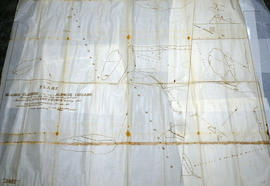
An original, waxed linen map entitled "Islands claimed by Alnwick Indians, Pursuant to Instructions bearing date Crown Lands, Dept. Quebec 2nd October 1861." The area in mention concerns the Huyck Bay Islands, Lake Ontario, and Pleasant Bay. Surveyed by Duncan McDonell Greenfield and John McNaughton, P. L. S. in May, June, July and August, 1862. Scale: 8 chains to an inch.
A map of the Ontario Provincial Electoral Districts during the 30th Parliament. Published by the External Policy Implementation Committee of Ontario Secondary School Teachers Federation.