The Wanamaker fonds consists of textual records and graphic materials of genealogical histories of various families. The fonds also contains records, brochures, pamphlets, publications, books, and other textual records from towns and cities throughout Ontario, predominantly from the Quinte Area and Hastings County.
Family Photographs of the Sayers family, Ralph Wanamaker's family, the Hodgen family, of Loral Wanamaker's family, Parliament family, Van Cott family, Post family, as well as loose photographs of the Parliament family, the McTaggart family, various snapshots and negatives of scenery and views, as well as 2 boxes of slides
1 box of Books and Binders with genealogical records, as well various records of various towns in Ontario ca. 1816 - 1957
Genealogical notes, histories, birth records, death records, pages from family Bibles, receipts, and other textual records for over 40 individual families
Genealogical charts, and ancestral charts
Genealogical correspondences *Newspapers, and News clippings from Hastings County, Hastings County Museum, Historical Society, Lennox and Addington, Prince Edward County, Trenton, Tyendinaga, and United Empire Loyalists
Legal documents, seals and original deeds, and land records ca. 1803 - 1848
Genealogy forms, research materials, reference materials
Various artworks and postcards (of Hastings County, the Quinte Region, the British Military and Navy, the Belleville Art Association, and travel)
Quinte region, Belleville, Trenton, and Prince Edward County miscellaneous publications, newspaper clippings, brochures, pamphlets, notes, directories, histories, records, and tourism guides and publications
Ontario, New York , and Canada pamphlets, magazines, calendars, and an Ontario Liquor License Act, 1891
Land Abstracts for Prince Edward County
Maps and plans: 1778-1779 Blue Print Surveys from General Washington, New York Historical Society; 1784 Ontario (printed by Ministry of Natural Resources), 1984; 1860-1861 Hastings County, 1860-1861 from the Hastings County Directory; 1928 Lloyd's Map of Hastings County; c. 1930 Belleville Post Office Carrier Route #8, North Front and North Park Streets
Scrapbooks ca. 1958-1972
Miscellaneous Publications (almanacs, newspaper clippings, miscellaneous pins belonging to Loral Wanamaker, blue print surveys)
Proposal submitted to Hastings County Council by the Hastings County Historical Society and the Hastings County Museum on 11 April 1975, to use the old Hastings Road as a historical tourist attraction.
Genealogical research materials on members of the Van Blaricom family, United Empire Loyalists and early settlers of Hastings and Prince Edward Counties in Ontario.
Release from right of forfeiture to Herman Haffner concerning property in the broken front in front of the east half of Lot 13 in the First Concession of Sidney Township, Hastings County, south of the road from Belleville to Trenton. Dated 24 July 1935.
Also includes an unfranked envelope with a 30-cent Terry Fox Marathon of Hope stamp, issued in 1982.
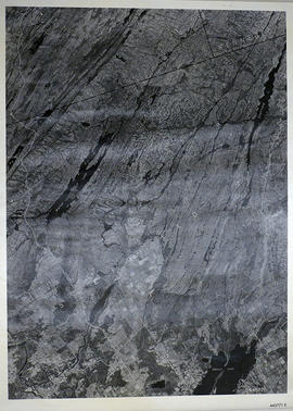
A reproduction of an air survey photograph produced by the Ontario Ministry of Natural Resources. Map # 444773E of Rawdon Township in Hastings County, Ontario. Circa 1950.
The photograph shows Rawdon Township from the eastern border to Hwy 14, Harold and Springbrook Villages, western Huntingdon Township, southern Marmora and Madoc Townships, Banker Lake.
Donated by Walter I. Watson, P.L.S.
Ontario. Ministry of Natural Resources and Forestry
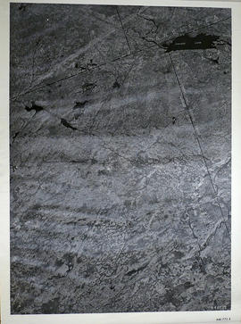
A reproduction of an air survey photograph produced by the Ontario Ministry of Natural Resources. Map # 444773W of Rawdon Township in Hastings County, Ontario. Circa 1950.
The photograph shows Rawdon Township, Concession 8 to 14, west of Hwy 14, small sections of Marmora Township including Marmora Village and Crow Lake and a small part of Seymour Township in Northumberland County
Donated by Walter I. Watson, P.L.S.
Ontario. Ministry of Natural Resources and Forestry
A reproduction of an air survey photograph produced by the Ontario Ministry of Natural Resources. Map #445771E of Sheffield Township in Lennox and Addington County, Ontario. Circa 1950.
The photograph shows Sheffield Township, Concession 3 to 9, Beaver Lake and north to Kaladar Township, Concession VIII to XI, Lingham Lakes in Grimthorpe Township in Hastings County.
Donated by Walter I. Watson, P.L.S.
Ontario. Ministry of Natural Resources and Forestry
A reproduction of an air survey photograph produced by the Ontario Ministry of Natural Resources. Map #446772E of Elzevir Township in Hastings County, Ontario. Circa 1950.
The photograph shows the North East part of Elzevir Township, Elzevir Creek and the Skootamata River.
Donated by Walter I. Watson, P.L.S.
Ontario. Ministry of Natural Resources and Forestry
A reproduced map detailing advance electoral polling stations within the City of Belleville. The map includes Bayview Mall, Fire Dept Training Office and St. Mark's United Church as stations, wards and boundaries.
City of Belleville. Information Technology Department
An aerial photograph of Napanee (Map # 49C4709/70). Map includes: Napanee River and Village in the Townships of South & North Fredericksburg. A small part of Ernestown & Camden Townships. Concession 1 to 5 of Richmond Township, Deseronto and Hay Bay Circa 1970. Scale: 1:2,000.
Map includes Trans-Northern Pipeline and Trans Canada Pipeline and the Hydro Lines. Donated by Walter I. Watson, P. L. S.
An aerial photograph of Tyendinaga Township, Concession 3 (Map # TD 19685Z). The photo includes Concession 3, Lots # 1 to 26 including proposed Hydro right of way and landowners names and instrument numbers Photographed on September 10, 1973 and annotations made July 27, 1976. Scale 1 inch = 200 feet. For the Ontario Hydro Route and site Selection Division, Orthophoto R/W Selection Plan Lennox G. S. - Oshawa Area T. S. Aerial View. By J. E. Clements- photogrammetric production officer; D. Crozier- chief draftsman; J. Sedgwal- project engineer; C. E. Bishop- Sr R/W planning engineer.
An aerial photograph of Sidney Township, Concession 3 (Map # TD19689Z). The photo includes Concession 3 and part of Concession 4, Lots A, # 1 to 21, including proposed Hydro right of way and landowners names and instrument numbers. Photographed on September 10, 1973 and annotations made July 27, 1976. Scale 1 inch = 200 feet. For the Ontario Hydro Route and site Selection Division, Orthophoto R/W Selection Plan Lennox G. S. - Oshawa Area T. S. Aerial View. By J. E. Clements- photogrammetric production officer; D. Crozier- chief draftsman; J. Sedgwal- project engineer; C. E. Bishop- Sr R/W planning engineer.
Plan showing Sidney Township, part of Lot # 31, Concession 4, and the proposed right of way for Ontario Hydro Lines. (Map # TD30198D). For Ontario Hydro, Design and Construction Branch, Surveys and Mapping. Scale 1 inch = 60 feet. Drawn by R. Sweeney.
Plan showing Sidney Township, part of Lots # 25 to 29, concession 4 & part of Lot # 25, Concession 3, for proposed right of way for Ontario Hydro Lines (Map # TD30199Z). For Ontario Hydro, Design and Construction Branch, Surveys and Mapping. Scale 1 inch = 200 feet. Drawn by R. Sweeney.
Plan showing Tyendinaga Township, Part of Lots # 31 to 40, concession 2 North range, Ontario Hydro proposed right to way (Map # TD30189Z). For Ontario Hydro, Design and Construction Branch, Surveys and Mapping. Scale 1 inch = 200 feet. Drawn by R. Sweeney, R. A. Schan, O .L. S.
Plan showing Richmond Township, Lennox & Addington County, Lots # 8 -12, Concession 3 & Lots # 1 to 12, Concession 4 (Map # TD19683Z). For Ontario Hydro, Route and Site Selection Division Orthophoto R/W Selection Plan. Scale: 1 inch = 20 feet. By J. E. Clements-photogrammetric production officer.