A certified reproduction of the Plan of Ponton's Block, being Lots # 21 & 22 on the south side of Bridge Street West, Belleville, for William Hamilton Ponton, on the Commercial Bank Plan. Surveyed by John J. Haslett P.L.S. in 1853.
This copy was made in 1972 of plan #27, as registered in the Hastings Land Registry Office.
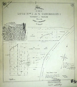
A certified reproduction of the "Plan of part of Lots # 1 & 2, Concession 1 Thurlow, Part of the Commercial Bank Plan. Resubdivided by owners Maria Murney and Nathaniel Baldwin Falkiner." Some of the lot owners are named along the south side of Charlotte Street: George Ritchie Lot # 28, Lt. Col. Campbell and Jacob Wilson Lot # 28. Surveyed by John D. Evans, P.L.S., and signed October 15, 1872.
This copy was made in 1972 of plan #158, as registered in the Hastings Land Registry Office.
Reproduction of a map of a town site at the mouth of the Moira River [Belleville, Ontario]. Features lot owners and businesses already located in the area. Original by Samuel Wilmot, April 24, 1816. Scale: 1= 1,500.
Printed by the Hastings County Historical Society in 1969.
A map showing, primarily, the depth of the Moira River within Belleville, Ontario. Together with a written report, it proposed a channel to the New Ferry Slip. Major streets and some lots are also labelled. By John D. Evans, P.L.S. on April 28, 1881 or 1887. Scale: 66 feet : 1". Note the interesting colouring at dimmed edges.
A map of Belleville, Hastings County, Ontario and its principal buildings. Produced c. 1878. Scale: 13 chains to an inch. Photocopied from Hastings County Directory at the Archives of Ontario (D-1).
A map of the Bellleville Harbour, in July-August 1880, featuring harbour dredging, flood limits of 1879; Flint & Holton's saw mill; Mill Island; Grand Junction Railway. By E. de Bouchinville. Scale: 400ft : 1 inch (original).
Reproduction made in 1976 of an 1875 map of the Belleville Harbour in Bay of Quinte. The map features major streets, buildings and depth readings of travelled waters. Surveyed by F. M. Hamel, C.E. Drawn by J. M. Faga. Scale: 1:6000.
A "Map of the Dominion of Canada and Newfoundland" published by the Copp Clark Co. Ltd. of Toronto in 1945.
The map served dual commercial and educational purposes. It advertises for a chocolate company with slogans and images: "Neilson's, The best chocolate bars in Canada [and] Neilson's Jersey milk chocolate - The best milk chocolate made." On the top right corner, an inscription writes that the map was for rural, underprivileged schools and was not to be removed from such locations.
1972 copy of an 1837 plan of 'Diseronca' (now Deseronto, Ontario), surveyed by G.J. Clapp on August 26th, 1837. The plan is Plan 43 of the plans registered in the Hastings County Registry.
The north-south streets shown on the right side of the map are, from right to left, First Street, Second Street, Third Street and Fourth Street. Near the end of Fourth Street a wharf is marked on the map. This is Culbertson's Wharf.
Hamilton & Hope Townships, Map (order) 841-5711 showing areas of; Hamilton & Hope Townships-including Cobourg & Port Hope showing Hydro lines and gas & oil pipelines. Dated August 27, 1973. Scale: 1 inch = 2000 feet.
A "Surveyor's Concept Plan of Belleville Waterfront in the future." Drawn by Paul Wiegand circa 1970. Includes heritage buildings moved to new location. Heritage buildings (left to right) Lynch House, [unknown] Patrie House, Margaret Simpson Inn (1820) [church], [house from Pinnacle or Church St.?] . . . 2nd from right: McIntosh, Ridley House, right: [unknown]; in foreground: Petrie Stone building. P. Wreg and Concept of Belleville Harbour.
A blueprint planning the suspension footbridge across the Moira River in Belleville, Ontario. Approved by Charles Mott - April 21, 1936. Submitted by Walter H. Patterson of the Patterson Construction Company.
Poor reproduction of a sketch of Upper Canada to show places designated by Lt. Gov. Simcoe for towns and proposed military roads, circa 1796. The map was published by B. M. Kings.
Reproduction of a map showing "the Routes Lt. Gov. J. G. Simcoe took on trips" throughout Upper Canada from March 1792 to September 1795. The map was charted by Lt. Gov. Simcoe. A good depiction of the area now referred to as Southern Ontario and his plans for a capital there - "London." This map was published as part of "Charting Our Past" from the Archives of Ontario by Stonehouse Publications.
A map showing a zoning limits street plan within the City of Belleville. The zones and symbols can be referenced on the legend. The map was published on February 6, 1974.
An 1877 map of Belleville, Hastings County, Ontario by Evans & Bolger, surveyors. Map includes a table showing dates of plans in the registry office with plan name, wards and dates.
A certified reproduction of the "Distillery Block - Lot # 50a on the north side of Dundas Street.” The block includes land on the north side of Dundas Street East between Ann Street and Albert Street, in Belleville. Surveyed by Evans and Bolger, P. L. S. and dated November 7, 1877.
This copy was made in 1972 of plan #207, as registered in the Hastings Land Registry Office.
A map showing the 37 polling subdivisions of Belleville, Hastings County, Ontario. Composed by Charles Mott from the City in August 1958 and published in The Ontario Intelligencer on 28 November 1958.