
Sprague Family, Prince Edward County History
- CA ON00156 TR/2771
- Item
- c. 1900
This file contains a newspaper clipping titled "The Sprague Family: How They Migrated From New York to Prince Edward".
16 results with digital objects Show results with digital objects
Sprague Family, Prince Edward County History
This file contains a newspaper clipping titled "The Sprague Family: How They Migrated From New York to Prince Edward".
The file contains a commemorative pamphlet on the history of the Weller's Stage Coach, along with a copy of an advertisement from the Cobourg Star (11 August 1841).
Map of Rivers and Lakes of Prince Edward County
Part of Map collection
Map showing depths of water and fishing areas[?] of the Bay of Quinte, from Belleville to Big Island and North Port.
van Burren, Jack

Hydrographic Map of Bay of Quinte, Picton to Presqu'ile Bay
Part of Map collection
A hydrographic map of the area surrounding the Bay of Quinte, Picton to Presqu'ile Bay in Ontario, Canada. With maps of Trenton Approaches, [racist slur redacted] Narrows, Belleville Harbour & Telegraph Narrows inset. Surveys completed in in 1952-53 and 1957. Map printed June 15, 1962. Published by the Canadian Hydrographic Service, Marine Sciences Branch, Department of Mines and Technical Surveys, Ottawa. Sheet number 2069.
Canadian Hydrographic Service

A family history on the Wilkins' family. 2 pages.
Topographical maps of Wellington
Part of Map collection
A topographical map of Wellington - Canada sheet #30 N/14, both east and west half sheets. Published by the Army Survey Establishment, Department of National Defence in 1951. Scale 1:50,000.
Canada. Department of National Defence

Topographical map of Duck Island
Part of Map collection
A topographical map of Duck Island- Canada sheet #30 N/15. Published by the Army Survey Establishment, Department of National Defence in 1932. Scale one inch to one mile - 1/63, 360.
Donated by Gerry Boyce.
Canada. Department of National Defence

Topographic Map of Ontario - Belleville Sheet
Part of Map collection
A map from the Eastern Canada series entitled "Topographic Map of Ontario - Belleville Sheet 31 C/3." The map includes Hastings County to Hillier in Prince Edward County. Published in 1938 by the Department of National Defence. Scale 1 inch to 1 mile.
Donated by the Belleville Public Library in 2014.
Canada. Department of National Defence
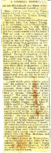
Young, Lieut. Col. Reuben Young - Obituary 1899
File contains the obituary (7-February-1899) for Lt. Col. Reuben Young. Born 19-July-1805 in Carrying Place, oldest son of Lieut. Col. James Young, M.P. Lt. Col. Reuben Young married Nancy Briant in 1829, she predeceased him 10 years.

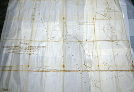
Weller's and Hay Bay Islands claimed by Alnwick Indians
Part of Map collection
An original, waxed linen map entitled "Plans of Islands claimed by the band of Alnwick Indians. Pursuant to Instructions bearing date “Crown Lands Department” Quebec 2nd October 1861." The area in mention concerns Weller's Bay and Hay Bay, in Prince Edward County. Surveyed by John McNaughton, P. L. S. in April and May 1862. Scale: 8 chains to an inch.
McNaughton, John, P.L.S. & D.P.S.

West Lake Islands claimed by Alnwick Indians
Part of Map collection
An original, waxed linen map entitled "Islands claimed by Alnwick Indians, Pursuant to Instructions bearing date Crown Lands, Dept. Quebec 2nd October 1861." The area in mention concerns the West Lake Islands, in Prince Edward County. Surveyed by Duncan McDonell Greenfield and John McNaughton, P. L. S. in May and June 1862. Scale: 8 chains to an inch.
McNaughton, John, P.L.S. & D.P.S.
Huyck Islands claimed by Alnwick Indians
Part of Map collection
An original, waxed linen map entitled "Islands claimed by Alnwick Indians, Pursuant to Instructions bearing date Crown Lands, Dept. Quebec 2nd October 1861." The area in mention concerns the Huyck Bay Islands, Lake Ontario, and Pleasant Bay. Surveyed by Duncan McDonell Greenfield and John McNaughton, P. L. S. in May, June, July and August, 1862. Scale: 8 chains to an inch.
McNaughton, John, P.L.S. & D.P.S.

Map of the Counties of Hastings and Prince Edward
Part of Map collection
A "Map of the Counties of Hastings and Prince Edward." In 1898, the lots, concessions, churches, schools and mines are shown of the townships in Hastings and Prince Edward. Scale: 1.5 miles to an inch. Published by the Canadian Map Publishing Company in Hamilton, Ontario, for the Belleville Sun. Revised by Henry Carre, C.E. Inset is the map of North Hastings, scale 400 chains to an inch.
Carre, Henry, O.L.S.
Election Canada Districts in Prince Edward County
Part of Map collection
A map detailing electoral districts #183 to 189 (inclusive) within Prince Edward County. The map includes polling divisions, road networks and municipal boundaries. Inset # 9, # 35073.
Canada. Department of Natural Resources

Topographical Map of Ontario - Belleville Sheet
Part of Map collection
A map of Hastings, Prince Edward, Northumberland and Peterborough counties in 1929 from the Department of Interior Canada. By J.E. Chalifour, Chief Geographer. Scale: 1" to 3.95 miles.
The legend includes additional information about counties, towns, villages, boundaries, railways, canals, lots, concessions, portages, rapids and First Nations Territories.
Canada. Department of the Interior
Map of Napanee Administrative District 1980
Part of Map collection
A map of the Napanee Administrative District including Northumberland, Hasting County, Prince Edward County, Lennox Addington counties. Published by the Ministry of Natural Resources in 1980.
Donated by the Belleville Public Library in 2014.
Ontario. Ministry of Natural Resources and Forestry
Regional Map of Belleville, Trenton, Sidney Township, Picton
Part of Map collection
A Regional Map of Belleville, Trenton, Sidney Township and Picton. Including advertisements around map. Composed by the Belleville & District Chamber of Commerce. Published by the Ontario Mapping Company in 1995.
Donated by the Belleville Public Library in 2014.
Belleville Chamber of Commerce
Hastings and Prince Edward Counties Topographical Map
Part of Map collection
A topographical map of Zone 18 - Hastings & Prince Edward Counties. Depicted current as of 1974. Printed 1977. Scale: 1:50,000. Published by the Mapping & Charting Establishment, Department of National Defence Canada. Belleville MCE 139, Edition 2. Transverse Mercator Projection, Contour Interval 25 ft. Elevations in Feet above sea level.
Canada. Department of National Defence
Map of Prince Edward County c.1975
Part of Map collection
Prince Edward County Map, circa 1975. Published by the Ministry of Transportation and Communications. Composed by Hon. James Snow (Minister) and Harold Gilbert (Deputy Minister).
Features: road jurisdictions, Kings Highways, secondary highways, county roads, township roads, roads legally open but not necessarily passable, urban corporate limits, railways and stations, township boundaries, county boundaries, populated areas.
Donated by the Belleville Public Library in 2014.
Ontario. Ministry of Transportation
Map of Prince Edward County 2001
Part of Map collection
Prince Edward County with Quinte's Isle in 2001. Published by the Prince Edward County Chamber of Tourism & Commerce.
Features: Map of Picton with West Lake & East Lake. Map Bloomfield & Wellington.
Donated by the Belleville Public Library in 2014.
Prince Edward County Chamber of Tourism and Commerce