Belleville Transit Rider Guide and Schedule 2015
- CA ON00156 M/M440/1823
- Pièce
- 2015
Fait partie de Map collection
A map featuring the transit routes, street routes and rider fares for the Belleville Bus Transit system.
Sans titre
815 résultats avec objets numériques Afficher les résultats avec des objets numériques
Belleville Transit Rider Guide and Schedule 2015
Fait partie de Map collection
A map featuring the transit routes, street routes and rider fares for the Belleville Bus Transit system.
Sans titre
Belleville Transit Rider Guide and Schedule 1979
Fait partie de Map collection
A map featuring the transit routes, street routes and rider fares for the Belleville Bus Transit system.
Sans titre
Belleville Transit Rider Guide and Schedule 2018
Fait partie de Map collection
A map featuring the transit routes, street routes and rider fares for the Belleville Bus Transit system.
Sans titre
Belleville Transit Rider Guide and Schedule 2017
Fait partie de Map collection
A map featuring the transit routes, street routes and rider fares for the Belleville Bus Transit system.
Sans titre
Belleville Transit Rider Guide and Schedule 2016
Fait partie de Map collection
A map featuring the transit routes, street routes and rider fares for the Belleville Bus Transit system.
Sans titre
Belleville Transit Rider Guide and Schedule 2010
Fait partie de Map collection
A map featuring the transit routes, street routes and rider fares for the Belleville Bus Transit system.
Sans titre

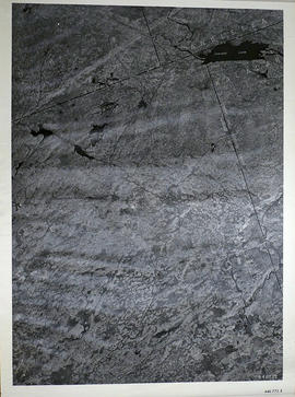
Fait partie de Map collection
A reproduction of an air survey photograph produced by the Ontario Ministry of Natural Resources. Map # 444773E of Rawdon Township in Hastings County, Ontario. Circa 1950.
The photograph shows Rawdon Township from the eastern border to Hwy 14, Harold and Springbrook Villages, western Huntingdon Township, southern Marmora and Madoc Townships, Banker Lake.
Donated by Walter I. Watson, P.L.S.
Sans titre

Fait partie de Map collection
A reproduction of an air survey photograph produced by the Ontario Ministry of Natural Resources. Map # 444773W of Rawdon Township in Hastings County, Ontario. Circa 1950.
The photograph shows Rawdon Township, Concession 8 to 14, west of Hwy 14, small sections of Marmora Township including Marmora Village and Crow Lake and a small part of Seymour Township in Northumberland County
Donated by Walter I. Watson, P.L.S.
Sans titre
Elzevir Township Map # 446772E
Fait partie de Map collection
A reproduction of an air survey photograph produced by the Ontario Ministry of Natural Resources. Map #446772E of Elzevir Township in Hastings County, Ontario. Circa 1950.
The photograph shows the North East part of Elzevir Township, Elzevir Creek and the Skootamata River.
Donated by Walter I. Watson, P.L.S.
Sans titre
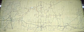
Election Canada Advance Polling Stations in Belleville
Fait partie de Map collection
A reproduced map detailing advance electoral polling stations within the City of Belleville. The map includes Bayview Mall, Fire Dept Training Office and St. Mark's United Church as stations, wards and boundaries.
Sans titre
Fait partie de Map collection
An aerial photograph of Napanee (Map # 49C4709/70). Map includes: Napanee River and Village in the Townships of South & North Fredericksburg. A small part of Ernestown & Camden Townships. Concession 1 to 5 of Richmond Township, Deseronto and Hay Bay Circa 1970. Scale: 1:2,000.
Map includes Trans-Northern Pipeline and Trans Canada Pipeline and the Hydro Lines. Donated by Walter I. Watson, P. L. S.
Ontario Hydro Aerial Photograph of Tyendinaga Township
Fait partie de Map collection
An aerial photograph of Tyendinaga Township, Concession 3 (Map # TD 19685Z). The photo includes Concession 3, Lots # 1 to 26 including proposed Hydro right of way and landowners names and instrument numbers Photographed on September 10, 1973 and annotations made July 27, 1976. Scale 1 inch = 200 feet.
For the Ontario Hydro Route and site Selection Division, Orthophoto R/W Selection Plan Lennox G. S. - Oshawa Area T. S. Aerial View.
By J. E. Clements- photogrammetric production officer; D. Crozier- chief draftsman; J. Sedgwal- project engineer; C. E. Bishop- Sr R/W planning engineer.
Sans titre
Ontario Hydro Aerial Photograph of Sidney Township
Fait partie de Map collection
An aerial photograph of Sidney Township, Concession 3 (Map # TD19689Z). The photo includes Concession 3 and part of Concession 4, Lots A, # 1 to 21, including proposed Hydro right of way and landowners names and instrument numbers. Photographed on September 10, 1973 and annotations made July 27, 1976. Scale 1 inch = 200 feet.
For the Ontario Hydro Route and site Selection Division, Orthophoto R/W Selection Plan Lennox G. S. - Oshawa Area T. S. Aerial View.
By J. E. Clements- photogrammetric production officer; D. Crozier- chief draftsman; J. Sedgwal- project engineer; C. E. Bishop- Sr R/W planning engineer.
Sans titre
Ontario Hydro Plan of Lot 31 Sidney Township
Fait partie de Map collection
Plan showing Sidney Township, part of Lot # 31, Concession 4, and the proposed right of way for Ontario Hydro Lines. (Map # TD30198D). For Ontario Hydro, Design and Construction Branch, Surveys and Mapping. Scale 1 inch = 60 feet. Drawn by R. Sweeney.
Sans titre
Ontario Hydro Plan of Lots 25-29 Sidney Township
Fait partie de Map collection
Plan showing Sidney Township, part of Lots # 25 to 29, concession 4 & part of Lot # 25, Concession 3, for proposed right of way for Ontario Hydro Lines (Map # TD30199Z). For Ontario Hydro, Design and Construction Branch, Surveys and Mapping. Scale 1 inch = 200 feet. Drawn by R. Sweeney.
Sans titre
Ontario Hydro Plan of Lots 31-40 in Tyendinaga Township
Fait partie de Map collection
Plan showing Tyendinaga Township, Part of Lots # 31 to 40, concession 2 North range, Ontario Hydro proposed right to way (Map # TD30189Z). For Ontario Hydro, Design and Construction Branch, Surveys and Mapping. Scale 1 inch = 200 feet. Drawn by R. Sweeney, R. A. Schan, O .L. S.
Sans titre
Aerial Photograph of Belleville
Fait partie de Map collection
Belleville, Map # 78-4413-24 showing areas of; North East Belleville, Alemite Park on South West corner of map, Moira Secondary School near South East corner of map and Leeming Farm on 3rd Concession Road at North side of map. Published by the Ministry of Natural Resources. Surveyed by Walter I. Watson, P.L.S. Circa 1970.
Sans titre
Aerial Photograph of Tudor Township
Fait partie de Map collection
Tudor Township, Map # 69.4432,6.275 showing areas of; Tudor Township- near Glamire Village on the Hastings Road, including the Beaver Creek and part of Glamire Lake and the road going North Easterly off Hastings Road at Glanmire. Published by the Department of Mines and Technical Surveys. Surveyed by EHR. Circa 1977.
Sans titre
Aerial Photograph of Tyendinaga Township
Fait partie de Map collection
An aerial photograph of Tyendinaga Township, Map # TD19684Z01. The total area covered includes, Lots # 22-40, Concession 2, Lot # 22-31, Concession 3 - showing orthophoto right of way Selection Plan. For Ontario Hydro - Route & Site Selection Division. Aerial photo taken on September 10, 1973 and published August 25, 1976. Scale: 1 inch = 200 feet.
Hydro-Electric Power Commission of Ontario, Tweed-Section
Fait partie de Map collection
An original map produced for the Hydro-Electric Power Commission of Ontario, concerning hydro power lines, stations and transformers. However, the map also features railways, roads and land boundaries.
This map is the West Centre Section - Tweed ROA. The total area includes parts of Rawdon, Marmora, Huntingdon, Madoc, Hungerford, and Elzevir Townships. Dated October 16, 1951. Scale: 1.2 inches = 1 m.
Donated by David Pershik.