- CA ON00156 2011-46
- Collection
- 1802-1864
Various notes and legal documents relating to Russell and Thomas Pitman of Thurlow Township, Hastings County. Partially transcribed by Lois Foster.
Sans titre
185 résultats avec objets numériques Afficher les résultats avec des objets numériques
Various notes and legal documents relating to Russell and Thomas Pitman of Thurlow Township, Hastings County. Partially transcribed by Lois Foster.
Sans titre
Register of marriage licences issued in Thurlow Township
Register of marriage licences issued between 21 March 1922 and 25 December 1926. There are two later entries, in pencil, for 10 February 1942 and 8 March 1946. In total there are 34 entries in this register.
Sans titre

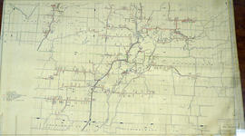
Hydro-Electric Power Commission of Ontario, Frankford Section
Fait partie de Map collection
An original map produced for the Hydro-Electric Power Commission of Ontario, concerning hydro power lines, stations and transformers. However, the map also features railways, roads and land boundaries.
This map is of the North Section - Frankford Rural Power District. The total area includes parts of Thurlow, Huntingdon, Sidney, Rawdon, Campbellford, Seymour, Brighton, and Percy Townships. Circa 1950.
Donated by David Pershik.
Hydro-Electric Power Commission of Ontario, Tweed Section
Fait partie de Map collection
An original map produced for the Hydro-Electric Power Commission of Ontario, concerning hydro power lines, stations and transformers. However, the map also features railways, roads and land boundaries.
This map is of the Southwest Section - Tweed Rural Power District. The total area includes parts of Hungerford, Huntingdon, and Thurlow Townships. Dated October 16, 1951. Scale: 2 inches = 1 mile.
Donated by David Pershik.
Fait partie de HCHS Textual Records collection: Files 3500 to 3916
Sale of lands in lots 21 and 22 in the fourth concession of Thurlow Township by Stephen Ostrum of Thurlow to Allen Ross of Thurlow.
Fait partie de HCHS Textual Records collection: Files 1 to 999
File contains biographical information of Anthony Burgess, an immigrant from Portugal who lived in Thurlow and was a sheep breeder in the 1870s.
Clarke, Ed. George; farm history – lot 13, con. 5, Thurlow
Fait partie de HCHS Textual Records collection: Files 1 to 999
File contains a questionnaire completed by Ed Clarke about his family farm's history for a Tweedsmuir history.
Rebellion Losses Claim # 60 : Henry Garrison, Thurlow
Fait partie de HCHS Textual Records collection: Files 2000 to 2499
File contains a manuscript claim submitted to the Provincial Government of Canada in 1845 by Henry Garrison for two days training “by order of Captain Frasier” in February, 1838.
Rebellion Losses Claim #78 : Nicholas O'Camb, Thurlow
Fait partie de HCHS Textual Records collection: Files 2000 to 2499
File contains a manuscript statement of damages submitted by Nicholas O'Camb to the Provincial Government in 1845 for damages resulting from imprisonment for 80 days in February to May, 1838.
Rebellion Losses Claim #80 : Daniel Chapman, Thurlow
Fait partie de HCHS Textual Records collection: Files 2000 to 2499
File contains a manuscript claim submitted by Daniel Chapman to the Provincial Government in 1845 for teaming services ordered by Captain Frasier in February, 1838.
Rebellion Losses Claim #81 : Thomas McCready, Thurlow
Fait partie de HCHS Textual Records collection: Files 2000 to 2499
File contains a manuscript claim submitted by Thomas McCready to the Provincial Government in 1845 for teaming services ordered by Captain Frasier in February, 1838.
Rebellion Losses Claim #84 : Henry Yager
Fait partie de HCHS Textual Records collection: Files 2000 to 2499
File contains a manuscript claim submitted to the Provincial Government in 1845 by H.W. Yager for the billeting of soldiers and the provision of arms and horses during 1838.
Rebellion Losses Claim #89: Stephen Mott, Thurlow
Fait partie de HCHS Textual Records collection: Files 2000 to 2499
File contains a manuscript statement of damages submitted to the Provincial Government in 1845 for losses incurred by Stephen Mott as a result of imprisonment in February, 1838.
Rebellion Losses Claim #91 : Elisha Ackerman
Fait partie de HCHS Textual Records collection: Files 2000 to 2499
File contains a manuscript claim submitted to the Provincial Government by Elisha Ackerman for damages arising from a two month and twenty day prison term at Fort Henry in 1838.
Peason, Hon. Lester B., Prime Minister : centennial message
Fait partie de HCHS Textual Records collection: Files 2000 to 2499
File contains a typescript letter signed by Hon. Lester B. Pearson congratulating Thurlow Township on the publication of a local history as part of a 1967 Centennial Year project.

Fait partie de Map collection
A regional planning map for the Village of Salem in Thurlow Township, February 1st, 1859. Area extends from concession #8 in lot 12. By Wm Wallbridge, P.L.S. Dimensions 71cm x 32cm. Scale: 1" = 2 chains.
Written in blue ink on the back of flowery wallpaper.
Donated by Mrs. R. Sills.
Sans titre

Resources Map of Hastings County
Fait partie de Map collection
Resources map of Hastings County, Ontario, showing agricultural activity and natural resources.
Forestry in the Townships of Hastings and Prince Edward Counties
Fait partie de Map collection
Forestry maps of Ameliasburgh, Murray, Rawdon, Sidney and Thurlow townships from 1980.

Plan of Hastings for Hastings Directory
Fait partie de Map collection
A map of Hastings County outlining townships:
Marmora, Lake, Madoc, Tudor, Grimsthorpe, Elzevir; Rawdon, Huntingdon, Hungerford, Sidney, Thurlow, Tyendinaga - as well as the northern townships.
Inset is "the Village of Marmora." Surveyed by H. A. F. Macleod, C.E. and P.L.S. Published by W. A. Little Lith., Montreal in the 1864-1865 copy of the Hastings Directory . Scale: 1:190,000.
Sans titre

Map of Hastings County in 4 sections
Fait partie de Map collection
A map of Hastings County outlining townships from the Bay of Quinte in the south, to Wallaston, Limerick and Cashel in the north.
Map is in four sections. Scale: 3 miles : 1 inch. Original map is dated 1894. Photocopy from the Archives of Ontario.