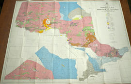
Map of Hastings County, Ontario
- CA ON00156 DA 2011.03
- Item
- c.1947
Map of Hastings County, Ontario, with business directory information for Belleville, Deseronto, Frankford, Madoc, Shannonville, Stirling and Tweed in the right and left-hand panels.
Croydon Publishing Company