Print preview Close

Showing 720 results

Archival description
Government
Print preview Hierarchy View:

136 results with digital objects Show results with digital objects

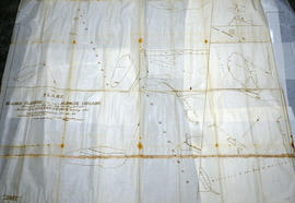
First Floor Plan at County Court House

A Floor Plan of the Main First Floor at the County Court House on Pinnacle Street in Belleville, Ontario. All rooms and areas are named: Turnkey's Apartment, Sheriff's Offices, Judge Cameron's Office, Jail Govenor's Office etc. Composed by Charles A. Mott, City Engineer, and dated November 15, 1944.

Donated by Heritage Belleville in 2017.

Mott, Charles Allan

Cell Block and Basement Plans at Court House

A Floor Plan of the Main Cell Block and Basement at the County Court House on Pinnacle Street in Belleville, Ontario. The “Old Cells” are in the basement of the Court House. The Main Cell Block is connected to the Court House on the southeast. Composed by Charles A. Mott, City Engineer, and dated November 15, 1944.

Donated by Heritage Belleville in 2017.

Mott, Charles Allan

Weller's and Hay Bay Islands claimed by Alnwick Indians

An original, waxed linen map entitled "Plans of Islands claimed by the band of Alnwick Indians. Pursuant to Instructions bearing date “Crown Lands Department” Quebec 2nd October 1861." The area in mention concerns Weller's Bay and Hay Bay, in Prince Edward County. Surveyed by John McNaughton, P. L. S. in April and May 1862. Scale: 8 chains to an inch.

McNaughton, John, P.L.S. & D.P.S.

West Lake Islands claimed by Alnwick Indians

An original, waxed linen map entitled "Islands claimed by Alnwick Indians, Pursuant to Instructions bearing date Crown Lands, Dept. Quebec 2nd October 1861." The area in mention concerns the West Lake Islands, in Prince Edward County. Surveyed by Duncan McDonell Greenfield and John McNaughton, P. L. S. in May and June 1862. Scale: 8 chains to an inch.

McNaughton, John, P.L.S. & D.P.S.

Huyck Islands claimed by Alnwick Indians

An original, waxed linen map entitled "Islands claimed by Alnwick Indians, Pursuant to Instructions bearing date Crown Lands, Dept. Quebec 2nd October 1861." The area in mention concerns the Huyck Bay Islands, Lake Ontario, and Pleasant Bay. Surveyed by Duncan McDonell Greenfield and John McNaughton, P. L. S. in May, June, July and August, 1862. Scale: 8 chains to an inch.

McNaughton, John, P.L.S. & D.P.S.

Map of the Province of Ontario in counties and districts

A "Map of the Province of Ontario in counties and districts" published by the Ontario Department of Municipal Affairs in 1963.

Part of the Van Blaricom collection. The areas where the Van Blaricom family was active is shaded in red ink,

Ontario. Department of Municipal Affairs

Electoral Map of the Province of Ontario

An Electoral Map of the Province of Ontario, including all of the electoral districts outlined in red. Composed by Surveyor General F. W. Beatty. Published by the Ontario Department of Lands & Forests in 1955. Scale 8 miles to an inch.

Donated by the Argue family in 2013.

Ontario. Department of Lands and Forests

Map of the Electoral District of Hastings, Ontario

  • CA ON00156 M/M480-2646 - 2652 and 2654/M430-2654
  • Item
  • c. 1961
  • Part of Map collection

A map of the electoral district of Hastings, Ontario. According to the Electoral Boundaries Readjustment Act for the 1961 Decennial Census, "Hastings" includes the City of Belleville, the Townships of Cashel, Dungannon, Elzevir, Faraday, Grimsthorpe, Hungerford, Huntingdon, Lake, Limerick, Madoc, Marmora, Mayo, Thurlow, Tudor, Tyendinaga and Wollaston. The map compliments of Lee Grills, M.P.

Elections Canada

Election Canada Districts in Belleville

  • CA ON00156 M/M480-2646 - 2652 and 2654/2652
  • Item
  • 2003
  • Part of Map collection

A map detailing electoral districts #78-503 (inclusive) within the City of Belleville. The map includes polling divisions, road networks and municipal boundaries. Inset No. 7. Federal No. 35073.

Canada. Department of Natural Resources

Election Canada Advance Polling Stations in Belleville

  • CA ON00156 M/M480-2646 - 2652 and 2654/2651
  • Item
  • 2014
  • Part of Map collection

A reproduced map detailing advance electoral polling stations within the City of Belleville. The map includes Bayview Mall, Fire Dept Training Office and St. Mark's United Church as stations, wards and boundaries.

City of Belleville. Information Technology Department

Election Canada Polling Stations in Belleville

  • CA ON00156 M/M480-2646 - 2652 and 2654/2650
  • Item
  • 2010
  • Part of Map collection

A reproduced map detailing electoral polling stations within the City of Belleville. The map includes numbered stations, washrooms, parking, roads and parks.

City of Belleville. Information Technology Department

Election Canada Districts in Deseronto

  • CA ON00156 M/M480-2646 - 2652 and 2654/2649
  • Item
  • 2003
  • Part of Map collection

2 maps detailing electoral districts #92, 95-97 (inclusive) and 100 within Deseronto, Hastings County. The map includes polling divisions, road networks and municipal boundaries. Inset No. 6. Federal No. 35073.

Canada. Department of Natural Resources

Election Canada Districts in Monteagle Township

  • CA ON00156 M/M480-2646 - 2652 and 2654/2648
  • Item
  • 2003
  • Part of Map collection

2 photocopies of maps detailing electoral districts #1, 2, 5, 8, 10, 19 within Monteagle Township, Hastings County. The map includes polling divisions, road networks and municipal boundaries. Polling Division # 9 and 9(1). Federal No. 35073.

Canada. Department of Natural Resources

Election Canada Districts in Prince Edward County

  • CA ON00156 M/M480-2646 - 2652 and 2654/2647
  • Item
  • 2003
  • Part of Map collection

A map detailing electoral districts #183 to 189 (inclusive) within Prince Edward County. The map includes polling divisions, road networks and municipal boundaries. Inset # 9, # 35073.

Canada. Department of Natural Resources

Election Canada Districts in Centre Hastings

  • CA ON00156 M/M480-2646 - 2652 and 2654/2646
  • Item
  • 2003
  • Part of Map collection

2 copies of maps detailing electoral districts #40 to 45 (inclusive) within Centre Hastings. The map includes polling divisions, road networks and municipal boundaries. Inset # 2, # 35073.

Canada. Department of Natural Resources

Map of Marmora Township

Map showing concessions, traveled roads and lots of Marmora Township, Hastings County. Areas of gold mines are also charted. Scale: 1 mile : 1 inch. Published by MacLeod & Carre Engineers and Surveyors in Belleville, Ontario (Canada West). Local advertisements surround map.

Received from the Public Archives of Canada on 3 May 1971.

MacLeod and Carre, P.L.S.

Hydrographic Map of Belleville Bridge to Telegraph Narrows

A hydrographic map of Belleville Bridge to Telegraph Narrows (Bay of Quinte) in Ontario, Canada. Surveys completed in 1893, 1953, 1957. Map printed July 30, 1959. Published by the Canadian Hydrographic Service, Surveys and Mapping Branch, Department of Mines and Technical Surveys, Ottawa.

Donated by the Glanmore National Historic Site in 2016.

Canadian Hydrographic Service

Results 61 to 80 of 720