1) Large format photographs (mostly mounted) which were formerly on display in Deseronto Town Hall. Town Council portraits from the following years: 1967 1971 [1970s] 1982-1985 1985-1988 1988-1991 1991-1994 1997-2000 2000-2003 2003-2006 Mounted copy of letter asking E.W. Rathbun to be Mayor in 1889 Letters of congratulations on 100th anniversary of Deseronto in 1989 Photo of Town Hall Portraits of Glenn Balcour as Warden of Hastings County 2) Four files of press cuttings relating to Deseronto Town Council from 1970s to 2003, covering water works, policing, taxes, events
Photographs of members of the council of the Town of Deseronto: George E. Clement James Sexsmith William Irvine James Whitton J. M. Olliver George Parnham A. A. Richardson, Deputy Reeve Frederick S. Rathbun, Treasurer Edward Wilkes Rathbun, Mayor Robert Irvine, Clerk James Dryden, Reeve J. McCollough, Assessor George Gonyou, Chief of Police G. E. Deroche, Solicitor T. D. Galt William Mellow James Saunders
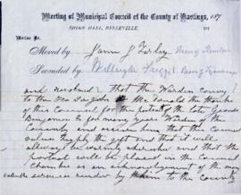
File contains a manuscript motion in Council by James J. Farley, Thurlow Township Reeve, to convey thanks to Sir. John A. Macdonald for a portrait of the late George Benjamin, Warden of Hastings County.
File contains a manuscript report of the Hastings County Council Committee of Whole, 1868, finding against a petition for the separation of Wollaston and Limerick Townships from Tudor Township and the creation of separate township councils.
Letter written by J.B. McGann to municipal and provincial government representatives of Ontario, asking for financial support on behalf of the Deaf and Dumb Institution.
File contains original petition to incorporate Mill Point into an "Incorporated Village" 17 May1871, signed by Edward Wilkes Rathbun and 100 residents of the village. There are also petitions of protest from residents north of the York Road [Highway 2] who did not want to be part of the village. File also includes a plan of the proposed boundaries Mill Point (Map M440-1446).
A reproduction of part of a map showing Lower Canada, Quebec and Ontario in 1825. Map shows bodies of water and names of settlements. The boundary of Lower Canada is according to a treaty with the United States. From the Archives of Canada on July 27, 1966. Donated by Chewett.
Reproduction of Part 2 of a map showing a plan of the Principal Settlements of Upper Canada in 1817. The area covers from Northumberland to Essex counties. This map can be found the Archives of Canada.
Reproduction of Part 1 of a map showing a plan of the Principal Settlements of Upper Canada in 1817. The area covers from Eastern to Midland to Home District. This map can be found the Archives of Canada.
A "Map of Canada - Exclusive of Northern Regions - Indicating Main Natural Resources." Map revised in 1936. Published by the Department of Mines & Resources (Canada). Scale: 100 miles to 1 inch.