Mostrando 263 resultados

Descripción archivística
Thurlow, Township of Unidad documental simple
Imprimir vista previa Hierarchy Ver :

178 resultados con objetos digitales Muestra los resultados con objetos digitales

Register of marriage licences issued in Thurlow Township

  • CA ON00156 2011-02
  • Unidad documental simple
  • 1922-1946

Register of marriage licences issued between 21 March 1922 and 25 December 1926. There are two later entries, in pencil, for 10 February 1942 and 8 March 1946. In total there are 34 entries in this register.

Sin título

Hydro-Electric Power Commission of Ontario, Frankford Section

  • CA ON00156 M/M430-2995 - 2996, 3018 - 3021, 3031/3020
  • Unidad documental simple
  • c. 1950
  • Parte deMap collection

An original map produced for the Hydro-Electric Power Commission of Ontario, concerning hydro power lines, stations and transformers. However, the map also features railways, roads and land boundaries.

This map is of the North Section - Frankford Rural Power District. The total area includes parts of Thurlow, Huntingdon, Sidney, Rawdon, Campbellford, Seymour, Brighton, and Percy Townships. Circa 1950.
Donated by David Pershik.

Hydro-Electric Power Commission of Ontario, Tweed Section

  • CA ON00156 M/M430-2995 - 2996, 3018 - 3021, 3031/3021
  • Unidad documental simple
  • 16 Oct 1951
  • Parte deMap collection

An original map produced for the Hydro-Electric Power Commission of Ontario, concerning hydro power lines, stations and transformers. However, the map also features railways, roads and land boundaries.

This map is of the Southwest Section - Tweed Rural Power District. The total area includes parts of Hungerford, Huntingdon, and Thurlow Townships. Dated October 16, 1951. Scale: 2 inches = 1 mile.

Donated by David Pershik.

Cannifton & The Holgate Family

This file contains a personal writing by Maribeth L. Bird of Belleville, dated 1983 and titled "Cannifton, The Seat of Thurlow Township, Hastings County, Ontario, Canada". It contains: a brief history of Cannifton and the people; several reproduced articles from the Intelligencer (death of a child, Clarence William Holgate), unveiling of a plaque in memory of Miss Mary Cowan, "Reminiscent of a Mark Twain Novel" by John Bateman. The majority of the book is a family genealogy starting with John and Mary Holgate, born in England and Scotland in the years 1791 and 1797. The family history also contains photocopies of family pictures.

Sin título

Village of Salem Planning Map

  • CA ON00156 M/M430-1193
  • Unidad documental simple
  • 1 Feb. 1859
  • Parte deMap collection

A regional planning map for the Village of Salem in Thurlow Township, February 1st, 1859. Area extends from concession #8 in lot 12. By Wm Wallbridge, P.L.S. Dimensions 71cm x 32cm. Scale: 1" = 2 chains.

Written in blue ink on the back of flowery wallpaper.

Donated by Mrs. R. Sills.

Sin título

Plan of Hastings for Hastings Directory

  • CA ON00156 M/M420-1080
  • Unidad documental simple
  • 1864-1865
  • Parte deMap collection

A map of Hastings County outlining townships:
Marmora, Lake, Madoc, Tudor, Grimsthorpe, Elzevir; Rawdon, Huntingdon, Hungerford, Sidney, Thurlow, Tyendinaga - as well as the northern townships.
Inset is "the Village of Marmora." Surveyed by H. A. F. Macleod, C.E. and P.L.S. Published by W. A. Little Lith., Montreal in the 1864-1865 copy of the Hastings Directory . Scale: 1:190,000.

Sin título

Map of Hastings County in 4 sections

  • CA ON00156 M/M420-1090
  • Unidad documental simple
  • 1894
  • Parte deMap collection

A map of Hastings County outlining townships from the Bay of Quinte in the south, to Wallaston, Limerick and Cashel in the north.
Map is in four sections. Scale: 3 miles : 1 inch. Original map is dated 1894. Photocopy from the Archives of Ontario.

Corporation of Thurlow Map of Roads

  • CA ON00156 M/M430-2813
  • Unidad documental simple
  • c. 1970
  • Parte deMap collection

A map from the Corporation of the Township of Thurlow showing Ontario Hydro lines, concessions and additional country roads. Circa 1970.
Donated by the City of Belleville.

Plan of Part of Lot #1 in the Township of Thurlow

  • CA ON00156 M/M440-2523
  • Unidad documental simple
  • 30 Nov 1846
  • Parte deMap collection

A certified reproduction of the "Plan of part of Lot # 1 in the First Concession of Thurlow, surveyed for Asa Yeomans.” The area includes; east of Sidney Street and south of Mill Street [now West Moira Street], being on the north half of Lot # 1 in the First Concession of Township of Thurlow. Surveyed by Samuel Manson Benson D. P. S. - November 30, 1846.

Donated by Walter I. Watson, P. L. S.

Sin título

Subdivision of Part of Lot 17 in the Township of Thurlow

  • CA ON00156 M/M440-2410
  • Unidad documental simple
  • 7 Jun 1967
  • Parte deMap collection

A certified reproduction of the "Subdivision of part of Lot # 17, Reg'd Plan No. 769, formerly Township of Thurlow now Belleville.” The area includes; Lot # 1, 2, 3 South of Auburn Street and East of Glendale Road and Northerly from College St. West. Surveyed by Ronald Benn O. L. S. and signed June 7, 1967.

Donated by Walter I. Watson, P. L. S.

Sin título

Subdivision of part of Lot 13 in the Township of Thurlow

  • CA ON00156 M/M440-2486
  • Unidad documental simple
  • 18 Oct 1973
  • Parte deMap collection

A certified reproduction of the "Subdivision of part of Lot # 13, Concession 1, Township of Thurlow, Belleville.” The area includes; Lot # 1 to 11, and Block “A” South of Bridge Street East and West of Haig Road. Surveyed by Walter I. Watson, O. L. S. and signed October 18, 1973.

Donated by Walter I. Watson, P. L. S.

Sin título

Map of the Counties of Hastings and Prince Edward

  • CA ON00156 M/M420-1093
  • Unidad documental simple
  • 1898
  • Parte deMap collection

A "Map of the Counties of Hastings and Prince Edward." In 1898, the lots, concessions, churches, schools and mines are shown of the townships in Hastings and Prince Edward. Scale: 1.5 miles to an inch. Published by the Canadian Map Publishing Company in Hamilton, Ontario, for the Belleville Sun. Revised by Henry Carre, C.E. Inset is the map of North Hastings, scale 400 chains to an inch.

Sin título

East Gate Subdivision in the City of Belleville

  • CA ON00156 M/M440-2374
  • Unidad documental simple
  • 10 Feb 1964
  • Parte deMap collection

A certified reproduction of the "Subdivision of Part of East ½ of Lot # 13, Concession 1, Township of Thurlow, now Belleville laid out for Maple View Realty Ltd. Pres. Maurice Rollins.” The area includes; Lots # 1 to 110 and Blocks A, B, C, D, E, F and Haig Road, Joyce Crescent, Richmond Grove, Janlyn Crescent, Whalen Court, all east of Haig Road. Surveyed by Walter I. Watson, O. L. S. and signed February 10, 1964.

Donated by Walter I. Watson, P. L. S.

Sin título

Registrar's Plan of part of Lot 3 in the Township of Thurlow

  • CA ON00156 M/M440-2400
  • Unidad documental simple
  • 23 Mar 1966
  • Parte deMap collection

A certified reproduction of the "Registrar's Compiled Plan: Part Lot # 3, Concession 2, Township of Thurlow, now City of Belleville.” The area includes; Lots # 1 to 24, west of North Front Street and north from Tracey Street. Prepared by S.C. Geneja CST, Registry Office, County of Hastings and signed March 23, 1966.

Donated by Walter I. Watson, P. L. S.

Sin título

Map of Thurlow Township with annotations

  • CA ON00156 M/M430-3061
  • Unidad documental simple
  • c. 1950
  • Parte deMap collection

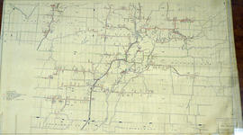
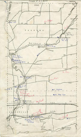
A map of Thurlow Township featuring the addition of handwritten annotations. Concessions, railways, proprietors, businesses and locations are featured. The map extends from the Bay of Quinte in the southwest to Roslin the northeast. Circa 1950 (Bakelite plant opened c. 1948 and the Foxboro Cheese Factory closed in 1961).

Specific annotations are as follows: Halloway Grist Mill, Latta Bridge, Plainfield Grist, Saw Mill, O'Brien's Bridge, Grist Mill, Canning Factory Foxboro, Footbridge, Cheese Factory, Fairfields Bridge, Dam Corbyville, Distillery, Cannifton Dam, Grist & Saw Mill, Quarry & Substation, Round House, Brickyard, Graham's Dried Foods, Bell Telephone Lines, Hydro Power Lines, and Cement Works.

Alternative Hydro Routes from Lennox to Oshawa

  • CA ON00156 M/M430-3062
  • Unidad documental simple
  • 21 Mar 1973
  • Parte deMap collection

A map studying alternative routes for hydroelectric power. The area covers from West Oshawa, East Mount Pleasant Jct. North Rice Lake & South Lake Ontario.

Sin título

Resultados 1 a 20 de 263