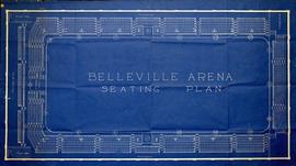
A blueprint of the Belleville Arena Seating Plan. The (Memorial) Arena is located on Market Street, between Pinnacle and Front Streets. Drawn by City Engineer, Charles A. Mott, and signed January 5, 1929.
A Floor Plan of the Main Cell Block and Basement at the County Court House on Pinnacle Street in Belleville, Ontario. The “Old Cells” are in the basement of the Court House. The Main Cell Block is connected to the Court House on the southeast. Composed by Charles A. Mott, City Engineer, and dated November 15, 1944.
A blueprint planning the CNR crossing and gas mains at Cannifton Road in Belleville, Ontario. Drawn by Charles Mott - September 21, 1929. Scale: 1" : 4'0. Features: 4/4/59 Canadian National Railways Agreement as to Laying Pipes Under Track.
A Floor Plan of the Main First Floor at the County Court House on Pinnacle Street in Belleville, Ontario. All rooms and areas are named: Turnkey's Apartment, Sheriff's Offices, Judge Cameron's Office, Jail Govenor's Office etc. Composed by Charles A. Mott, City Engineer, and dated November 15, 1944.
A blueprint planning the suspension footbridge across the Moira River in Belleville, Ontario. Approved by Charles Mott - April 21, 1936. Submitted by Walter H. Patterson of the Patterson Construction Company.
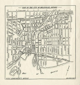
A map of the City of Belleville showing planned usage of the land - see legend for the different uses. Composed by Charles A. Mott and published by the City Engineers Office. Dated January 1949. Scale 1:8000.
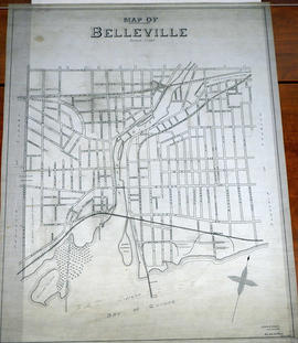
A Map of the City of Belleville, Ontario. The developed streets are pictured alongside their names. Local water ways including the Bay of Quinte and the Moira River are also present. Composed by Charles A. Mott and published by the City Engineers Office. Circa 1950.
A map of the City of Belleville, Ontario. The developed streets are pictured alongside their names. Local water ways including the Bay of Quinte and the Moira River are also present. Composed by Charles A. Mott and published by the City Engineers Office. Circa 1950.
Dated after the city limit expansion of 1948 but before the expansion in 1959.
A reproduction of a blueprint for Market Square between Front Street and Pinnacle Street in Belleville, Ontario. Including the Police Station, sidewalks, Beer Warehouse, dwellings etc. Surveyed by Charles D. Campbell. Signed by City Engineer, Charles A. Mott, on January 5, 1929.
A seating plan of the auditorium at Belleville City Hall, drawn in ink. Composed by Charles A. Mott, City Engineer, in February of 1924. The plan features the stage, council chambers and offices. Super-imposed on the plan (in pencil) is the layout of 4 apartments. They were used in 1946 during an acute housing crisis, to house 4 different families. The council at the time agree to the idea and allowed them to stay for almost 2 years.
A circa 1940 "Clearview" city directory map of Belleville, Ontario. The map features streets, water ways and major city buildings, as seen in the legend. Surveyed by Charles A. Mott, City Engineer. Published by Vernon Directories (Hamilton, Ontario). Heading of the map "Central Ontario Credit Exchange, The home of Collections, East Robertson Block, 219 Front Street, Licenced and Bonded Collection Specialists."
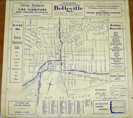
A 1932 "Clearview" city directory map of Belleville, Ontario. The map features streets, water ways and major city buildings, as seen in the legend. Composed by Charles A. Mott, City Engineer. Published by Vernon Directories (Hamilton, Ontario) and Might Directories (Toronto, Ontario). Six advertisements also border the map.