A map showing the 37 polling subdivisions of Belleville, Hastings County, Ontario. Composed by Charles Mott from the City in August 1958 and published in The Ontario Intelligencer on 28 November 1958.
A reproduction of "A New and Accurate Map of Part of North-America, Comprehending the Provinces of New England, New York, Pennsilvania, New Jersey, Connecticut, Rhode Island & Part of Virginia, Canada and Halifax, For the Illustration of M. Peter Kalms Travels." Written at the bottom is "Publish'd according to Act of Parliament Mrahc 7th, 1771."
A "New Map of Upper & Lower Canada" published December 1, 1807. Scale: British statute 69.5 miles to a degree. Created by John Cary, engraver and map-seller, No. 181 strand, London.
A certified reproduction of "Taylor's Plan of George Street (added to the plan by John Emerson, P. L. S.) by Samuel M. Benson, P. L. S. on north 40 feet of Lot # 45 to access Adam Street from road between Lots # 8 & 9 in 2nd Concession Thurlow for George Taylor." Signed August 25, 1874.
This copy was made in 1972 of plan #175, as registered in the Hastings Land Registry Office.
A reproduction of an aerial view photograph of the Belleville Harbour at the mouth of the Moira River in Belleville, Ontario. The photograph includes oil tanks, coal piles and trains. Circa 1933.
A reproduction of a pre-1949 aerial view photo located in a tourism advertisement book. The booklet advertises Quinte's cruising waters extending from Trenton to Adolphus Reach.
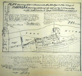
A certified reproduction of the "Alterations in Plan of part of Village of Marmora shewing additional lots laid out by T. P. Pearce on Lots # 7 & 8 in Concession 4 Township of Marmora.” Surveyed by C. Fraser Aylsworth Jr. P. L. S., and signed July 18, 1891.
This copy was made in 1972 of plan #285, as registered in the Hastings Land Registry Office.
A reproduction by the Canadian Department of Energy, Mines and Resources of "An Accurate Map of Canada with the adjacent Countries Exhibiting the late Seat of War between the English & French in those parts." Original map was issued in 1761 at London. Includes the areas named; New South Wales, New Britain, Canada, south Louisiana, Virginia, "Pennsilvania," New York and New England. The names and location of Indigenous peoples are also featured on the map.
A plan of Lots 174-179 (inclusive) on the shore of York River, in the town of Bancroft. Scale 100 feet to an inch. The original plan was drawn for Billa Flint on September 13, 1888. It was traced on tissue paper and registered as a Town Plan on December 15, 1911.
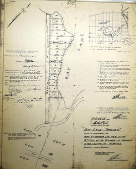
A certified reproduction of the "Bay Lake Shores subdivision of Lot # 4 in Concession 9, Township of Faraday.” The area includes the southwest shore of Bay Lake in Faraday Township. Surveyed by Garnet Lawrence Berkeley, O. L. S. and signed February 5, 1949.
A certified reproduction of the "Bay Lake Shores- Unit No. 2...subdivision of part of Lots # 4 and 5 in the 9th Concession of Township of Faraday.” The area includes Lots # 1 to 36 along the shore of Bay Lake. Surveyed by Garnet Lawrence Berkeley, O. L. S. and signed August 21, 1950.
This copy was made in 1972 of plan #850, as registered in the Hastings Land Registry Office.
A certified reproduction of the "Bell Subdivision - part of Lot # 38, Concession 2, north of College Street West, Township of Sidney, now City of Bellevile - owners Edgar H. Bell and Gloria J. Bell.” The area includes; north of College Street West and west of Sidney Street Lots # 1 to 5. Surveyed by Ronald Benn, O. L. S. and signed December 23, 1963.
Reproduction made in 1976 of an 1875 map of the Belleville Harbour in Bay of Quinte. The map features major streets, buildings and depth readings of travelled waters. Surveyed by F. M. Hamel, C.E. Drawn by J. M. Faga. Scale: 1:6000.
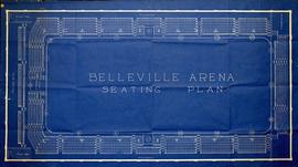
A blueprint of the Belleville Arena Seating Plan. The (Memorial) Arena is located on Market Street, between Pinnacle and Front Streets. Drawn by City Engineer, Charles A. Mott, and signed January 5, 1929.
5 sheets from a map series of the City of Belleville, including property boundaries, buildings and topographical features. Photography for maps completed on April 26, 1964.
Donated by the Heritage Belleville Committee in 2017.
A map of heritage buildings, using Goad's Fire Insurance Maps from 1904-1908, in the East Hill area of Belleville, Ontario. Prepared by the Local Architectural Conservation Advisory Committee in 1985. A colour chart dictates red for first priority; yellow for important to the street scape; blue for lost heritage; green for open areas.
Reproduction of an 1874 Bird's Eye View of Napanee, Ontario, showing buildings that existed at that time. The original map was drawn by Herman Brosius and printed by Charles Sober & Co. of Chicago.
A blueprint plan showing land required by the Canadian Northern Ontario Railway for a proposed right-of-way on Lots 1-2A, Dundas Street, Belleville. The property belonging to Mary E. Ponton is coloured in pink and amounts to 1.05 acres. The plan was signed on October 23, 1911 at Toronto.