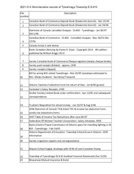
Administrative records of S.S. #10, Tyendinaga Township
- CA ON00156 2021-014
- Collection
- 1914-1956
Correspondence and financial records relating to the administration of S.S. #10 in Tyendinaga Township, Ontario.
Tyendinaga School Section No. 10
Administrative records of S.S. #10, Tyendinaga Township
Correspondence and financial records relating to the administration of S.S. #10 in Tyendinaga Township, Ontario.
Tyendinaga School Section No. 10

Correspondence of the Little and King families of Milltown
Letters written by members of the Little and King families of Tyendinaga Township and Fulton, New York. Includes some family history information, a postcard of Stirling and a photograph of Edith Roulston, taken in 1960.

Hastings with Town of Belleville and principal villages
Part of Map collection
A map of Hastings County including the Town of Belleville and other principal villages:
Trenton, Madoc, Marmora, Tweed, Bridgewater, Stirling, Wicklow, Bangor, Herschel, Monteagle, Carl, Dungannon, Wollaston, Limerick, Cashel, Tudor, Grimsthorpe, Elzevir; Rawdon, Huntingdon, Hungerford, Sidney, Thurlow, Tyendinaga.
Scale: 3 miles =1 inch. Published by John P. Evans, P.L.S. in 1869.
Evans, John Dunlop, P.L.S.
Hydro-Electric Power Commission of Ontario, Napanee Section
Part of Map collection
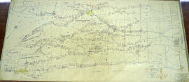
An original map produced for the Hydro-Electric Power Commission of Ontario, concerning hydro power lines, stations and transformers. However, the map also features railways, roads and land boundaries.
This map is of the South Section - Napanee Rural Power District. The total area includes parts of Ernestown, Frederickburgh South, Frederickburgh, Richmond, Tyendinaga, and Adolphustown Townships. Dated January 23, 1942. Scale: 2 inches = 1 mile.
Donated by David Pershik.

Hydro-Electric Power Commission of Ontario, Napanee Section
Part of Map collection
A reproduction of an original map produced for the Hydro-Electric Power Commission of Ontario, concerning the boundaries of the Napanee Rural Power District, center section. However, the map also features railways, roads and land boundaries. Dated March 2, 1931. Scale: 2 inches = 1 mile.
The map includes the townships of Tyendinaga, Richmond and Camden (East).
Donated by David Pershick.

Lloyd's Map of Hastings County
Part of Map collection
A map of Hastings County outlining the twelve townships:
Marmora and Lake, Madoc, Tudor, Grimsthorpe, Elzevir; Rawdon, Huntingdon, Hungerford, Sidney, Thurlow, Tyendinaga. The northern townships are pictured on the right side.
As well as, the lots and concessions. Circa 1922. Scale: 1.5 miles: 1 inch. Published by Lloyd's Maps, Map Publisher.
Lloyd's Map, Map Publisher

Map of Deseronto city lots and ownership
Part of Map collection
A map of lots and their owners in the town of Deseronto in Hastings County, Ontario. Black lines show claims to holdings in 1890 and red lines show lots as staked. Scale 1:12,000. Dated 1890.

Map of Hastings and Prince Edward Counties
Part of Map collection
A map showing the roads, forts and inns of Hastings and Prince Edward Counties in 1850, by Major Baron DeRottenburg. The map extends from Brighton to Gananoque, Prince Edward County. and North to include Rawdon, Huntingdon, Hungerford Townships of Hastings County. Scale: 2 miles = 1". Dimensions 63cm x 44cm.
DeRottenburg, Major Baron

Map of Hastings County in 4 sections
Part of Map collection
A map of Hastings County outlining townships from the Bay of Quinte in the south, to Wallaston, Limerick and Cashel in the north.
Map is in four sections. Scale: 3 miles : 1 inch. Original map is dated 1894. Photocopy from the Archives of Ontario.

Map of Hastings with the Principal Villages and the City of Belleville
Part of Map collection
A map of Hastings County including the Town of Belleville and other principal villages:
Trenton, Madoc, Marmora, Tweed, Bridgewater, Stirling, Wicklow, Bangor, Herschel, Monteagle, Carl, Dungannon, Wollaston, Limerick, Cashel, Tudor, Grimsthorpe, Elzevir; Rawdon, Huntingdon, Hungerford, Sidney, Thurlow, Tyendinaga.
Scale: 3 miles =1 inch. Published by Evans & Bolger, P. L. Surveyors, P.L.S. in 1879-1880.
Evans and Bolger

Map of Hastings with townships
Part of Map collection
A map of Hastings County outlining the twelve townships:
Marmora and Lake, Madoc, Tudor, Grimsthorpe, Elzevir; Rawdon, Huntingdon, Hungerford, Sidney, Thurlow, Tyendinaga.
As well as, the lots and concessions. Circa 1916.Scale: 4 miles: 1 inch.
Donated by K.G.M. Ross.

Map of Southern Hastings County
Part of Map collection
Southern Hastings County in 1963. Map features boundaries, roads and railways. Scale: 1:63,360. Published by the Department of Highways, Ontario. Made by Hunting Survey Corp. Ltd. Dimensions 107.5cm x 92.5cm.
A unique "one-inch" map because all one-inch series maps were converted to 1:50,000 after 1950. However, this map was converted to 1:63,360.
Ontario. Department of Highways

Map of the Counties of Hastings and Prince Edward
Part of Map collection
A "Map of the Counties of Hastings and Prince Edward." In 1898, the lots, concessions, churches, schools and mines are shown of the townships in Hastings and Prince Edward. Scale: 1.5 miles to an inch. Published by the Canadian Map Publishing Company in Hamilton, Ontario, for the Belleville Sun. Revised by Henry Carre, C.E. Inset is the map of North Hastings, scale 400 chains to an inch.
Carre, Henry, O.L.S.
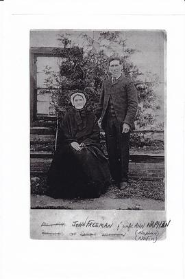
Photocopy of photograph of James and Ann Freeman of Tyendinaga Township, Ontario
Photocopy of a photograph of John Freeman (1836-1905) and his wife, Ann Naphan (1824-1923). At one time they owned the Arlington Hotel in Deseronto, Ontario.
Plan of Garrison Cemetery in the Township of Tyendinaga
Part of Map collection
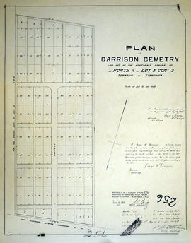
A certified reproduction of the "Plan of Garrison Cemetry, Laid out on the northeast corner of the north half of Lot # 3, Concession 3, Tyendinaga Township. Owned & authorized by George W. Garrison.” Surveyed by Bolger and Drewry, P.L.S., and signed December 3, 1886.
This copy was made in 1972 of plan #256, as registered in the Hastings Land Registry Office.
Donated by Walter I. Watson, P. L. S.
Bolger and Drewry, P.L.S.

Plan of Hastings for Hastings Directory
Part of Map collection
A map of Hastings County outlining townships:
Marmora, Lake, Madoc, Tudor, Grimsthorpe, Elzevir; Rawdon, Huntingdon, Hungerford, Sidney, Thurlow, Tyendinaga - as well as the northern townships.
Inset is "the Village of Marmora." Surveyed by H. A. F. Macleod, C.E. and P.L.S. Published by W. A. Little Lith., Montreal in the 1864-1865 copy of the Hastings Directory . Scale: 1:190,000.
MacLeod, Henry Augustine Fitzgerald, P.L.S.

Plan of Lonsdale in the Township of Tyendinaga
Part of Map collection
A certified reproduction of the Plan of Lonsdale on part Lot # 32 in 3rd Concession of Tyendinaga Township. Showing the island and 2 bridges on the north side of Mill Pond on the Salmon River. Surveyed by William Wallbridge, P.L.S. in 1854.
This copy was made in 1972 of plan #41, as registered in the Hastings Land Registry Office.
Donated by Walter I. Watson, O.L.S.
Wallbridge, William, P.L.S.
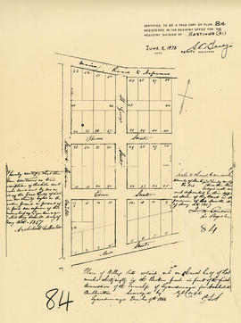
Plan of Lot 38 in the village of Millpoint (Deseronto)
Part of Map collection
A certified reproduction of the Plan of Village lots as laid out on the east half of Lot 38 in the Broken Front of the 1st Concessionof the Township of Tyendinaga for Archibald Culbertson. Surveyed by Publius V. Elmore, P.L.S. and signed May 7, 1857.
This copy was made in 1972 of plan 84, as registered in the Hastings Land Registry Office.
Donated by Walter I. Watson, O.L.S.
Elmore, Publius Virgillius, D.P.S.

Plan of north Shannonville in the Township of Tyendinaga
Part of Map collection
A certified reproduction of the Plan of north Shannonville - on the south part of Lot # 6, 1st Concession in the Township of 'Tyendenaga', property of Robert Clarke. Surveyed by Publius V. Elmore, P.L.S. and signed September 13, 1856.
This copy was made in 1972 of plan #79, as registered in the Hastings Land Registry Office.
Donated by Walter I. Watson, O.L.S.
Elmore, Publius Virgillius, D.P.S.
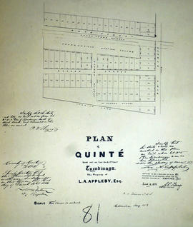
Plan of Quinte in the Township of Tyendinaga
Part of Map collection
A certified reproduction of the Plan of Quinte, laid out on Lot # 5, 1st Concession of Tyendinaga Township, property of L. A. Appleby. Map shows - Shannonville Station ground and also Grand Trunk Railway. Surveyed by Publius V. Elmore, P.L.S. and signed March 3, 1856.
This copy was made in 1972 of plan #81, as registered in the Hastings Land Registry Office.
Donated by Walter I. Watson, O.L.S.
Elmore, Publius Virgillius, D.P.S.