Showing 49 results

Archival description
Madoc, Township of With digital objects
Print preview Hierarchy View:

Madoc : Hannah family genealogy

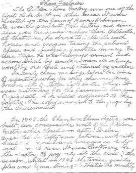
File contains a typescript extract from the Hastings County Court Registry Office concerning the ownership of a piece of land in Madoc Township, granted to C. Gordon Hannah in 1861. The lot is not identified, but information from the land index maintained by the Marilyn Adams Genealogical Research Centre suggest that it is lot 24 in the seventh concession of Madoc Township.

Madoc Township : history of Bannockburn

File contains original and photocopied manuscript histories of the settlement and early development of Bannockburn including the lumbering and sawmilling industries. Includes a printout of a webpage on Maitland House (available on the Internet Archive's Wayback Machine at https://web.archive.org/web/20010805101431/http://casa-de.vrx.net/buildings/) and an article from the Fall 2019 Country Roads magazine about the conversion of St. Bartholomew Anglican Church in Bannockburn into a private home.

Madoc Township Map # 445772W

  • CA ON00156 M/M470-2591 - 2616/2609
  • Item
  • c. 1950
  • Part of Map collection

A reproduction of an air survey photograph produced by the Ontario Ministry of Natural Resources. Map #445772W of Madoc Township in Hastings County, Ontario. Circa 1950.

The photograph shows Madoc Township, Concession 5 to 9, Huntingdon Township Concession 14, northwest Elzevir Township, Queenboro and Black River.

Donated by Walter I. Watson, P.L.S.

Ontario. Ministry of Natural Resources and Forestry

Madoc Township Map # 445773E

  • CA ON00156 M/M470-2591 - 2616/2609
  • Item
  • c. 1950
  • Part of Map collection

A reproduction of an air survey photograph produced by the Ontario Ministry of Natural Resources. Map #445773E of Madoc Township in Hastings County, Ontario. Circa 1950.

The photograph shows Madoc Township, Concession 1 to 7, Hwy 62, and Moira River Watershed, Eldorado, Lake Township, Concession 3 to 10.

Donated by Walter I. Watson, P.L.S.

Ontario. Ministry of Natural Resources and Forestry

Madoc Township Map # 446773E

  • CA ON00156 M/M470-2591 - 2616/2615
  • Item
  • c. 1950
  • Part of Map collection

A reproduction of an air survey photograph produced by the Ontario Ministry of Natural Resources. Map #446773E of Madoc Township in Hastings County, Ontario. Circa 1950.

The photograph shows the northern part of Madoc Township, Bannockburn, Tudor Township, Concession 1 to 9, Robinson Lake, Westerly to Millbridge, Moira River, Highway 62, and the Canadian National Railway.

Donated by Walter I. Watson, P.L.S.

Ontario. Ministry of Natural Resources and Forestry

Hydro-Electric Power Commission of Ontario, Tweed-Section

  • CA ON00156 M/M430-2995 - 2996, 3018 - 3021, 3031/3018
  • Item
  • 16 Oct 1951
  • Part of Map collection

An original map produced for the Hydro-Electric Power Commission of Ontario, concerning hydro power lines, stations and transformers. However, the map also features railways, roads and land boundaries.

This map is the West Centre Section - Tweed ROA. The total area includes parts of Rawdon, Marmora, Huntingdon, Madoc, Hungerford, and Elzevir Townships. Dated October 16, 1951. Scale: 1.2 inches = 1 m.

Donated by David Pershik.

Plan of Hastings for Hastings Directory

A map of Hastings County outlining townships:
Marmora, Lake, Madoc, Tudor, Grimsthorpe, Elzevir; Rawdon, Huntingdon, Hungerford, Sidney, Thurlow, Tyendinaga - as well as the northern townships.
Inset is "the Village of Marmora." Surveyed by H. A. F. Macleod, C.E. and P.L.S. Published by W. A. Little Lith., Montreal in the 1864-1865 copy of the Hastings Directory . Scale: 1:190,000.

MacLeod, Henry Augustine Fitzgerald, P.L.S.

Map of Hastings with the Principal Villages and the City of Belleville

A map of Hastings County including the Town of Belleville and other principal villages:

Trenton, Madoc, Marmora, Tweed, Bridgewater, Stirling, Wicklow, Bangor, Herschel, Monteagle, Carl, Dungannon, Wollaston, Limerick, Cashel, Tudor, Grimsthorpe, Elzevir; Rawdon, Huntingdon, Hungerford, Sidney, Thurlow, Tyendinaga.

Scale: 3 miles =1 inch. Published by Evans & Bolger, P. L. Surveyors, P.L.S. in 1879-1880.

Evans and Bolger

Map of Hastings County in 4 sections

A map of Hastings County outlining townships from the Bay of Quinte in the south, to Wallaston, Limerick and Cashel in the north.
Map is in four sections. Scale: 3 miles : 1 inch. Original map is dated 1894. Photocopy from the Archives of Ontario.

Results 1 to 20 of 49