An original map produced for the Seymour Power & Electric Co. Limited, concerning proposed transmission lines within the Township of Murray. However, the map also features railways, roads, mills and land boundaries. Circa 1910. Scale: 50 chains = 1 inch. Map composed by Smith, Kerry and Chace Engineers located in Toronto, Winnipeg, Calgary and Vancouver.
An original map produced for the Trenton Electric & Water Co. Limited, concerning proposed transmission lines within the Township of Sidney. However, the map also features railways, roads and land boundaries. Circa 1910. Scale: 50 chains = 1 inch. Map composed by Smith, Kerry and Chace Engineers located in Toronto, Winnipeg, Calgary and Vancouver.
A map of a town plot at the mouth of the Trent River in the Newcastle District. The map features numbered lots, present streets and water ways. Scale: 1 inch = 2 chains. Originally surveyed by F. P. Rubidge, D.P.S., in 1834. This copy was issued September 23, 1926.
A blueprint planning the floor of the COR and CPR Union Station at Trenton, Hastings County, Ontario. Drawn by John Dunlop Evans, Chief Surveyor/Engineer - August 23, 1897.
File contains: Exhibit 18, Trenton from minute book page 201 concerning the making Trenton C. North Railway Co. its divisional points & conditions 28 July 1911; Exhibit 5, Agreement between C. North Railway Co. & Town of Trenton, lists railways agreements 1 August 1911; Exhibit 14, re. abandonment of operation of Deseronto subdivision between Trenton Order No. 52012 Board of Railway Commissioners of Canada, Ottawa 12 June 1935
File contains a number of newspaper photos from various dates and titled "Picture Peeks Into The Past", these are pictures of boats in and on the Trent River and about boating in Trenton.
File contains a newspaper article from The Intelligencer, dated 22-July-1967 and titled "It's Only Five Minutes But it Starts Drivers Fuming" and is about the swing bridge in Trenton.
File contains a newspaper article and a photocopy of the same, with a reproduction of a sketch of Bleecker's hotel and ferry as they appeared in the 1830s. The ferry served as a crossing for the Trent at the location of the present Highway 2 bridge in Trenton.
File contains a manuscript license issued by the Province of Ontario on 13 October 1879 approving the operation of a ferry from Sidney Township in Hastings County to Ameliasburgh Township in Prince Edward County. Also present are two printed, completed bills of sale, dated 5 November 1880 transferring 64 shares in the steam paddler, Mary Ethel, built at Trenton, to the Bay of Quinte Navigation Company (Limited).
An original map produced for the Trenton Electric & Water Co. Limited, concerning their water mains, towers and substations within the Township of Thurlow. However, the map also features railways, roads and land boundaries. Circa 1910. Scale: 50 chains = 1 inch. Map composed by Smith, Kerry and Chace Engineers located in Toronto, Winnipeg, Calgary and Vancouver.
Eighteen photo-postcards of Hastings County scenes, taken by William Freeman. They include images of Bannockburn (2), Eldorado (4), Moscow (1), and Trenton (3). Items donated in 2011 include a photograph of Oran Tripp at Trenton, snapshots of the Rose family of Millbridge, a Model T at Bannockburn in 1911 and three C.N.R. engines at Bannockburn in 1912.
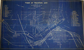
A photocopy of a map of the Town of Trenton, circa 1915. The map features advertisements for local businesses, important sites, industries and many railways and stations.
A map of the town of Trenton, Ontario in June 1926. The map features numbered lots, present industries, CNR tracks and other important buildings. Streets and their names, as well as the River Trent are also present. Scale: 1:3000. Composed by Mayor W. A. Fraser and published by his Town Council.
File contains several newspaper clippings from the Ontario Intelligencer and other sources regarding various issues including : proceedings of Trenton council meetings, bridge reconstruction, and school construction.