A reproduced map detailing advance electoral polling stations within the City of Belleville. The map includes Bayview Mall, Fire Dept Training Office and St. Mark's United Church as stations, wards and boundaries.
A map showing Essex County in southwestern Ontario, 1887. It features information and reference to railways at the time. Published and donated by S.R.G. Penson. Received from the Archives of Canada's map collection - 27 Jul. 1966.
A map showing counties from Belleville to Ottawa, Ontario, 1887. Published and donated by S.R.G. Penson. Received from the Archives of Canada's map collection - 27 Jul. 1966.
Proposal plan for Quinte area containing Sidney and Thurlow townships. Dated 31 Oct 1978. Scale: as shown. Published by the Quinte Planning Board. Composed by Laura.
A map showing the 37 polling subdivisions of Belleville, Hastings County, Ontario. Composed by Charles Mott from the City in August 1958 and published in The Ontario Intelligencer on 28 November 1958.
A map showing the members of parliament to the federal constituencies of Ontario, Canada. Published by External Policy Implementation Committee of Ontario Secondary School Teachers Federation.
A certified reproduction of the "Subdivision of part of Lots # 27 & 28, Concession XII, Township of Bangor surveyed for Dept. of Lands & Forests.” The area includes; Kamaniskeg Lake- Lots # 1 to 14 on the West and Northerly shore. Surveyed by Grange W. Elliott, O. L. S. and signed May 22, 1968. Scale: 1 inch = 100 ft.
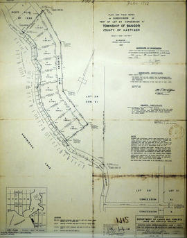
A certified reproduction of the "Subdivision of parts of Lots # 28 & 29, Concession XII, Township Bangor, surveyed for Dept. of Lands & Forests.” The area includes; Kamaniskeg Lake Lots # 15 to 30 and Blocks A-B. Block A is designated as public Hwy. The lots are along the west shore starting at the Road allowance between Concession XII and XIII.. Surveyed by Grange W. Elliott, O. L. S. and signed March 3, 1969.
A certified reproduction of the "Subdivision of part of Lots # 29 & 30, Concession XIV, Township of Bangor, Surveyed for Dept. Lands and Forests.” The area includes; Lots # 71 to 81, Blocks A, B, C on the west shore of Kamaniskeg Lake. Surveyed by Grange W. Elliott, O. L. S. and signed March 3, 1969.
A certified reproduction of the "Subdivision of part of Lots # 29 & 30, Concession VIII, Township of Cashel, surveyed for Dept. of Lands & Forests.” The area includes; Lots # 1 to 17 on the south shore of Mephisto Lake, being on Lots # 29 & 30, Concession VIII, Township of Cashel. Surveyed by N. H. Verhoef, O. L. S. and signed December 12, 1969.
A certified reproduction of the "Subdivision of part of Lots # 26 & 27, Concession X, and part of Lot # 28, Concession IX, Township of Cashel.” The area includes; Lots # 1 to 12 on the north shore of Mephisto Lake being on Lot # 26 & 27 on Concession X and Lot # 28, Concession IX, Township of Cashel. Surveyed by N. H. Verhoef, O. L. S. and signed December 2, 1969.
A certified reproduction of the "Subdivision of Part of Lot # 29, Concession XI, Township of Bangor, prepared for Dept. Lands & Forests, Lands & Surveys Branch.” The area includes; the east shore of Kaminiskeg Lake, Lot # 29, Concession XI, Bangor Township. Surveyed by M.J. McAlpine, O. L. S. and signed December 6, 1965.
A certified reproduction of the "Registrar's compiled plan, part of Lot # 26, in Broken Front Concession Township of Sidney.” The area includes; Lots west ½ and east ½ of Lot 26, Broken Front, being the north of side of Hwy 2. Registered March 9, 1967.
A certified reproduction of the "Subdivision of part of Lot # 17, Reg'd Plan No. 769, formerly Township of Thurlow now Belleville.” The area includes; Lot # 1, 2, 3 South of Auburn Street and East of Glendale Road and Northerly from College St. West. Surveyed by Ronald Benn O. L. S. and signed June 7, 1967.
A certified reproduction of the "Subdivision part of Lot # 28, Concession 7, Township of Bangor, Laid out for Dept. Lands and Forests.” The area includes; Lots # 1 to 6 along the douth shore of Kamaniskeg Lake being on Lot # 28, Concession 7, Bangor Township. Surveyed by Grange W. Elliott, O.L.S. and signed October 13, 1966.
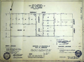
A certified reproduction of the "Subdivision of part of Lot # 19, Reg'd plan no. 797, Belleville for Charles W. Lambert Ltd.” The area includes; Lots # 1 to 8 and Block A-B west of Lemoine St., south of Parkdale Drive and both sides of Glendale Road and north of College St. West. Surveyed by Thomas S. Ransom, O. L. S. and signed December 21, 1966.
A certified reproduction of the "Registrar's compiled plan, being a graphic index of part of Lot # 28, Concession 1, Township of Sidney now City of Belleville.” The area includes; 14 Lots in Concession 1, west of Sidney Street and south of Moira Street. Surveyed by S. C. Geneja CST, Registry Office of Hastings and signed May 10, 1968.
A certified reproduction of the "Registrar's Compiled Plan, being a graphic index of part of Lot # 37, Concession 1, Township of Sidney... now City of Belleville.” The area includes; Lots # 1 to 15 Westerly from Sidney Street to Palmer Road and Northerly from Bridge St. West to Moira Street West.. Surveyed by S. C. Geneja CST, Registry Office of Hastings and signed May 28, 1968.
A certified reproduction of the "Registrar's Compiled Plan- being a graphic index of Lots # 6, 27, 28 and part of Lot # 21, Plan 1631, Township of Sidney.” The area includes; Lots # 1 to 48 Northerly from Hwy 2 to Canadian Pacific Railway and Easterly of Montrose Drive and County Club Drive. Surveyed by Walter I. Watson, O. L. S. and signed January 29, 1970.