A map featuring the streets in the City of Belleville, as well as important buildings (e.g. schools, churches etc.). Sponsored by and featuring advertisements from local businesses. Their contact information is listed. Published by OSM Networks Inc.
A map celebrating Ontario's Bicentennial (1784-1984) in the City of Belleville. The map features general points of interest, churches, fishing information, the Farmer's Market, and parking.
A map featuring the streets in the City of Belleville, as well as important buildings (e.g. schools, churches etc.). Sponsored by and featuring advertisements from McDonald's, Four Seasons Sports, J. F. Nelles & Associates Inc., Complete Rent-alls, Lyons Motors, Shell and Midas.
A map of the City of Belleville in Hastings County, Ontario. Composed and published by Pathfinder Air Surveys Ltd., in 1978-79. Insets include: 1) Street index 2) Industries index 3) Businesses and services index 4) Legend 5) List of cities with Pathfinder map suppliers 6) Survey information
A map featuring the streets in the City of Belleville, as well as important buildings (e.g. schools, churches etc.). Sponsored by and featuring advertisements from McDonald's, Four Seasons Sports, National Real Estate Service, Lester's Restaurant and Petro-Canada.
A map featuring the towns, cities and major tourist attractions from Belleville to Brockville. Sponsored by Rideau Marina Kingston Ltd, Atlantis Direct Marketing Inc., and CKWS television. On the reverse - brief explanations of the major cities/towns.
A pamphlet describing a 250km tour of historical attractions within Hastings, Prince Edward, Lennox and Addington counties. The history of each destination (e.g. the Macpherson House) is given, as well as its location on a map.
A road map of the northern and southern portions of the Province of Ontario. Published by the Ontario Department of Highways in 1967 for the Centennial Year. Various indexes and legends are located on the map.
A road map of the northern and southern portions of the Province of Ontario. Published by the Ontario Department of Highways in 1956. Various indexes and legends are located on the map.
A road map of the northern and southern portions of the Province of Ontario. Published by the Ontario Department of Highways in 1953. Various indexes and legends are located on the map.
A road map of Hastings County in 1953. Portions of adjoining counties are also pictured. Boundaries are yellow, while roads are blue and red. Published by the Ontario Department of Highways. Scale: 1 inch = 4 miles.
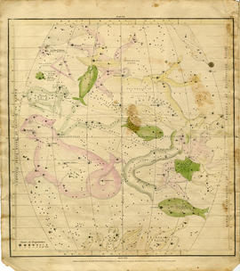
A "Celestial Atlas designed to illustrate the Geography of the Heavens" by Elijah Hinsdale Burritt, an American astronomer and mathematician. This second edition was published in 1833 by F. J. Huntingdon in the Clerk's Office of the District Court of Connecticut. The pages are as follows:
"The visible heavens in October, November and December."
"The visible heavens in January, February and March."
"The visible heavens in April, May and June."
"The visible heavens in July, August and September."
"The visible heavens in the North polar region for each month of the year."
"The visible heavens in the South polar region for each month of the year."
"Planisphere of the whole heavens on Mercator's projection."
A map featuring the streets in Belleville (includes Belleville & Thurlow Wards), Quinte West (includes Trenton, Sidney, Murray & Frankford Wards), Prince Edward & District including Brighton, Campbellford/Seymour, Colborne, Deseronto, Centre Hastings, Madoc, Marmora, Stirling/Rawdon, Tweed, Tyendinaga.
A double-sided map of the accommodations, camping and attractions located in Land O' Lakes. Includes North & West of Kingston including Napanee, the Frontenacs, Loyalist Country & Mazinaw Country. Advertisements surround the map. Dated 1982.
A road map of Hastings County in 1956. Portions of adjoining counties are also pictured. Boundaries are yellow, while roads are blue and red. Published by the Ontario Department of Highways. Scale: 1 inch = 4 miles. Dimensions: 72cm x 46.5cm.
A road map of the northern and southern portions of the Province of Ontario. Published by the Ontario Department of Highways in 1964. Various indexes and legends are located on the map.
3 copies of a map of the Crowe Lake Waterway Association in the Municipality of Marmora and Lake. The map shows major highways, islands, water ways and bodies of water including; Highway 7, Big Island, Crowe Lake, Crowe River etc. Also includes some topographical levels.