- CA ON00156 2010-41
- Item
- c.1980
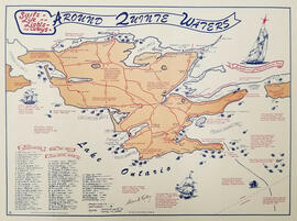
Map showing the location, names and dates of shipwrecks around the shoreline of Prince Edward County.
Ralley, Allan A.
16 results with digital objects Show results with digital objects
Map showing the location, names and dates of shipwrecks around the shoreline of Prince Edward County.
Ralley, Allan A.
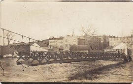
Photo-postcards of flooding in Belleville
Three photo-postcards of flooding of Front Street and the Moira river and damage to the footbridge in Belleville, Ontario.
Front page of Northern Telecom publication "The Switching Post"
Front cover of Northern Telecom publication The Switching Post for January/February/March 1981, with an aerial photograph of flooding on the west side of Belleville, west of Coleman Street and north of Dundas Street.
Nortel Networks
Quinte Field Naturalists records
Records of the Quinte Field Naturalists consisting of:
Quinte Field Naturalists

Drone photograph of wildfire smoke over Belleville, Ontario
Photograph taken by drone of wildfire smoke conditions in Belleville, Ontario.
Goulah, Andrew


Photograph of the interior of a shoe store and photographs of 1936 floods in Belleville
Five photographs:
1) Interior of J. J. Haines shoe store at 230 Front Street in Belleville, c.1920
2-5) Photo-postcards of flooding on Bridge, Coleman and Front Streets in Belleville, 1936
Belleville and Suburban Planning Board minutes and reports
Bound reports and minutes of meetings of the Belleville and Suburban Planning Board.
City of Belleville. Planning Department

Digital photographs taken during the COVID-19 crisis in Belleville
Thirteen photographs of parks, malls, hospital and grocery stores in Belleville, Ontario during the COVID-19 crisis.
Lantz, Paul

Postcards of Belleville floods and road to Rice Lake
Postcards of Belleville floods (mainly 1936), mostly duplicates of others in the collection.
Digital photographs and scans taken by Paul Lantz
Digital photographs:
Lantz, Paul

Photographs of Belleville floods and parade
Thirteen photographs of flooding in downtown Belleville in 1936 and four photographs of a parade passing along Front Street at Bridge Street in Belleville. The man and woman in the photographs have been identified by the donor as Winnifred Clark [the donor's mother] and her brother-in-law, Harold Thurgood. The child is likely to be one of Harold’s daughters, Barbara or Marilyn.
Thurgood, Harold
Photocopy of Community Improvement Plan, Town of Deseronto
Community Improvement Plan revised on 12 December 1988 (project number 24-7109-07).
Totten Sims Hubicki Associates Limited
Collection of Belleville-related materials
Collection comprises:
1) 56 colour photographs of the proposed route of the Riverfront Trail in Belleville, c.2001
2) Environmental Screening Report for the City of Belleville Riverfront Trail, July 2001
3) Moira River Fish Habitat Restoration Project Design Brief, August 2003
4) City of Belleville Structure Dedication Ceremony program for the dedication of: Bruce Faulds Track, Palmer Road; Wilbur C. Purcell Bridge, Dundas Street; Ben Corke Footbridge; Jean Smith Non-Profit Housing Complex, Brown Street; Tom Gavey Alemite Park, Pine Street; Putman Bridge, Cannifton Road North and Maitland Drive; Gerry Masterson Community Centre, Harmony Road, Thurlow, 25 October 2003
5) History, Customs, and Traditions, The Hastings & Prince Edward Regiment (26 pages), May 2014
City of Belleville
Two maps:
1) Plan of Belleville Harbour area, South Front Street, South Church Street, South John Street and South George Street, showing filled-in city dump area and former shoreline, by John T. Ransom, 1947
2) Plan of the mouth of the Moira river, showing the CPR railway bridge and filled-in land, by Tom Ransom, 1961
Ransom, John Thomas, P.L.S.
Moira River Conservation Authority and O'Hara Mill collection
Box of materials relating to the Moira Conservation Authority and O'Hara Mill, formerly owned by Lois Wishart (the donor's mother).
Moira River Conservation Authority
Belleville environmental reports
Collection of reports on environmental issues:
1) Zwick's Island Landfill Environmental Investigations Final Report by the Ontario Ministry of the Environment, October 1991
2) Interim Status Report South Front Street Reconstruction and Meyer's Pier Park Development by Golder Associates, March 1994
3) Phase I-IV Environmental Site Assessment of the Meyers Pier Park Development, Draft Final Report Volume I, by the City of Belleville Parks and Recreation Department, September 1996
4) Bayshore cleanup newspaper clippings, 1995-1998

Two photographs:
1) Portrait of a seated man and small child, possibly members of the Walmsley family, taken by D. A. Weese of 279 Front Street, Belleville, Ontario
2) View of floodwaters from CPR tracks near Dundas Street West in Belleville, Ontario, March 1936
Weese, Durwood Alexander

Photographs of 1981 spring flood in Belleville, Ontario
Sixteen colour photographs of ice and flooding along the Moira river in Belleville, Ontario.