- CA ON00156 M/M425-1028-1031, 1038 & M400-3042, 3043, 3047/M425-1029
- Item
- 2003
Part of Map collection
Ontario. Ministry of Transportation
881 results with digital objects Show results with digital objects
Part of Map collection
Ontario. Ministry of Transportation
Part of Map collection
Road Map of Ontario, 2008-2009
Part of Map collection
Ontario. Ministry of Transportation
Part of Map collection
Ontario. Ministry of Transportation
Belleville Transit Rider Guide and Schedule 2015
Part of Map collection
A map featuring the transit routes, street routes and rider fares for the Belleville Bus Transit system.
Belleville Transit Commission
Belleville Transit Rider Guide and Schedule 1979
Part of Map collection
A map featuring the transit routes, street routes and rider fares for the Belleville Bus Transit system.
Belleville Transit Commission
Belleville Transit Rider Guide and Schedule 2018
Part of Map collection
A map featuring the transit routes, street routes and rider fares for the Belleville Bus Transit system.
Belleville Transit Commission
Belleville Transit Rider Guide and Schedule 2017
Part of Map collection
A map featuring the transit routes, street routes and rider fares for the Belleville Bus Transit system.
Belleville Transit Commission
Belleville Transit Rider Guide and Schedule 2016
Part of Map collection
A map featuring the transit routes, street routes and rider fares for the Belleville Bus Transit system.
Belleville Transit Commission
Belleville Transit Rider Guide and Schedule 2010
Part of Map collection
A map featuring the transit routes, street routes and rider fares for the Belleville Bus Transit system.
Belleville Transit Commission

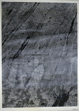
Part of Map collection
A reproduction of an air survey photograph produced by the Ontario Ministry of Natural Resources. Map # 444773E of Rawdon Township in Hastings County, Ontario. Circa 1950.
The photograph shows Rawdon Township from the eastern border to Hwy 14, Harold and Springbrook Villages, western Huntingdon Township, southern Marmora and Madoc Townships, Banker Lake.
Donated by Walter I. Watson, P.L.S.
Ontario. Ministry of Natural Resources and Forestry

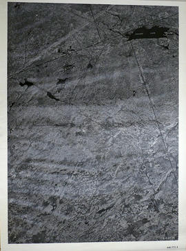
Part of Map collection
A reproduction of an air survey photograph produced by the Ontario Ministry of Natural Resources. Map # 444773W of Rawdon Township in Hastings County, Ontario. Circa 1950.
The photograph shows Rawdon Township, Concession 8 to 14, west of Hwy 14, small sections of Marmora Township including Marmora Village and Crow Lake and a small part of Seymour Township in Northumberland County
Donated by Walter I. Watson, P.L.S.
Ontario. Ministry of Natural Resources and Forestry
Sheffield Township Map # 445771E
Part of Map collection
A reproduction of an air survey photograph produced by the Ontario Ministry of Natural Resources. Map #445771E of Sheffield Township in Lennox and Addington County, Ontario. Circa 1950.
The photograph shows Sheffield Township, Concession 3 to 9, Beaver Lake and north to Kaladar Township, Concession VIII to XI, Lingham Lakes in Grimthorpe Township in Hastings County.
Donated by Walter I. Watson, P.L.S.
Ontario. Ministry of Natural Resources and Forestry
Elzevir Township Map # 446772E
Part of Map collection
A reproduction of an air survey photograph produced by the Ontario Ministry of Natural Resources. Map #446772E of Elzevir Township in Hastings County, Ontario. Circa 1950.
The photograph shows the North East part of Elzevir Township, Elzevir Creek and the Skootamata River.
Donated by Walter I. Watson, P.L.S.
Ontario. Ministry of Natural Resources and Forestry
Election Canada Advance Polling Stations in Belleville
Part of Map collection
A reproduced map detailing advance electoral polling stations within the City of Belleville. The map includes Bayview Mall, Fire Dept Training Office and St. Mark's United Church as stations, wards and boundaries.
City of Belleville. Information Technology Department
Part of Map collection
An aerial photograph of Napanee (Map # 49C4709/70). Map includes: Napanee River and Village in the Townships of South & North Fredericksburg. A small part of Ernestown & Camden Townships. Concession 1 to 5 of Richmond Township, Deseronto and Hay Bay Circa 1970. Scale: 1:2,000.
Map includes Trans-Northern Pipeline and Trans Canada Pipeline and the Hydro Lines. Donated by Walter I. Watson, P. L. S.
Ontario Hydro Aerial Photograph of Tyendinaga Township
Part of Map collection
An aerial photograph of Tyendinaga Township, Concession 3 (Map # TD 19685Z). The photo includes Concession 3, Lots # 1 to 26 including proposed Hydro right of way and landowners names and instrument numbers Photographed on September 10, 1973 and annotations made July 27, 1976. Scale 1 inch = 200 feet.
For the Ontario Hydro Route and site Selection Division, Orthophoto R/W Selection Plan Lennox G. S. - Oshawa Area T. S. Aerial View.
By J. E. Clements- photogrammetric production officer; D. Crozier- chief draftsman; J. Sedgwal- project engineer; C. E. Bishop- Sr R/W planning engineer.
Ontario Hydro
Ontario Hydro Aerial Photograph of Sidney Township
Part of Map collection
An aerial photograph of Sidney Township, Concession 3 (Map # TD19689Z). The photo includes Concession 3 and part of Concession 4, Lots A, # 1 to 21, including proposed Hydro right of way and landowners names and instrument numbers. Photographed on September 10, 1973 and annotations made July 27, 1976. Scale 1 inch = 200 feet.
For the Ontario Hydro Route and site Selection Division, Orthophoto R/W Selection Plan Lennox G. S. - Oshawa Area T. S. Aerial View.
By J. E. Clements- photogrammetric production officer; D. Crozier- chief draftsman; J. Sedgwal- project engineer; C. E. Bishop- Sr R/W planning engineer.
Ontario Hydro
Ontario Hydro Plan of Lot 31 Sidney Township
Part of Map collection
Plan showing Sidney Township, part of Lot # 31, Concession 4, and the proposed right of way for Ontario Hydro Lines. (Map # TD30198D). For Ontario Hydro, Design and Construction Branch, Surveys and Mapping. Scale 1 inch = 60 feet. Drawn by R. Sweeney.
Ontario Hydro
Ontario Hydro Plan of Lots 25-29 Sidney Township
Part of Map collection
Plan showing Sidney Township, part of Lots # 25 to 29, concession 4 & part of Lot # 25, Concession 3, for proposed right of way for Ontario Hydro Lines (Map # TD30199Z). For Ontario Hydro, Design and Construction Branch, Surveys and Mapping. Scale 1 inch = 200 feet. Drawn by R. Sweeney.
Ontario Hydro