Showing 114 results

Archival description
Stirling
Print preview Hierarchy View:

26 results with digital objects Show results with digital objects

Fidlar, Edward, Rawdon 1834

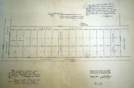
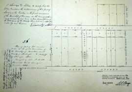
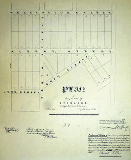
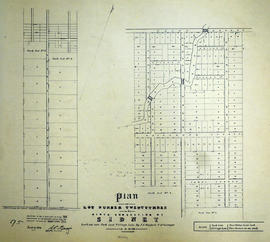
File contains original manuscript mortgage registration for a mortgage held by William Robertson on a property in Stirling, Rawdon Township, purchased by Edward Fidlar. Also contains a manuscript and printed indenture of bargain and sale between Edward Fidlar and Simon Root for land in the village of Stirling.

Plan of part of Lot 12 in the Township of Rawdon

A certified reproduction of the Plan of part Lot # 12 in 1st Concession of Rawdon, for proprietor Joseph Green. The lot is bounded by Marmora Road, Church Street. the Line between Concessions 11 & 12 and Front Street. Surveyed by John J. Haslett, P.L.S. and signed in December 1849.

This copy was made in 1972 of plan #52, as registered in the Hastings Land Registry Office.

Donated by Walter I. Watson, O.L.S.

Haslett, John James, P.L.S. & D.P.S.

Plan of Lot 23 in the village of Rawdon (Stirling)

A certified reproduction of the Plan of part of Rawdon (Stirling) Village, the north end of Lot # 23 in 9th Concession of Rawdon Township. A tannery is by the shore of Rawdon Creek and buildings are on Wright Street and John Street. An “Old Bridge” & a “New Bridge” extend over the Creek. Surveyed by John J. Haslett, P.L.S. in 1849.

This copy was made in 1972 of plan #54, as registered in the Hastings Land Registry Office.

Donated by Walter I. Watson, O.L.S.

Haslett, John James, P.L.S. & D.P.S.

Plan of part of east Lot 11 in the village of Rawdon (Stirling)

  • CA ON00156 M/M430-1754
  • Item
  • Jun 1847 - May 1849
  • Part of Map collection

A certified reproduction of the Plan of part of Rawdon (Stirling) Village: the east half of Lot # 11 in 1st Concession of Rawdon Township. Property of Edward Fidlar. Depicted are bridges, buildings of Grist Mill & Saw Mill on Rawdon Creek. Surveyed by John J. Haslett, P.L.S. and signed May 1849.

This copy was made in 1972 of plan #59, as registered in the Hastings Land Registry Office.

Donated by Walter I. Watson, O.L.S.

Haslett, John James, P.L.S. & D.P.S.

Plan of part of Lot 12 in the Township of Rawdon

A certified reproduction of the Plan of part of Lot # 12 in 1st Concession of Rawdon Township. Property of Ebenezer D. Allan. Note that this plan became a part of the village of Stirling. Surveyed by John J. Haslett, P.L.S. and signed December 1849.

This copy was made in 1972 of plan #56, as registered in the Hastings Land Registry Office.

Donated by Walter I. Watson, O.L.S.

Haslett, John James, P.L.S. & D.P.S.

Plan of Lot 11 in the village of Stirling

A certified reproduction of the Plan of part of the Village of Stirling, Lot # 11 in 1st Concession of Rawdon Township, owned by Edward Fidlar. Surveyed by John Emerson, P.L.S. and signed October 1852.

This copy was made in 1972 of plan #37, as registered in the Hastings Land Registry Office.

Donated by Walter I. Watson, O.L.S.

Emerson, John, P.L.S.

Plan of Allan's Block in the village of Stirling

A certified reproduction of the Plan of Allan's Block, part Lot # 12 in 1st Concession of Township of Rawdon (Stirling). Surveyed by John J. Haslett, P.L.S. in 1853.

This copy was made in 1972 of plan #57, as registered in the Hastings Land Registry Office.

Donated by Walter I. Watson, O.L.S.

Haslett, John James, P.L.S. & D.P.S.

Plan of Higgins Block in the village of Rawdon (Stirling)

A certified reproduction of the Plan of Higgins Block, part of Lot # 13 in the 1st Concession of Rawdon Township, for Thomas Jahred Higgins. One building marked “School House” on the west side of Marmora Street. Surveyed by John J. Haslett, P.L.S. in 1853.

This copy was made in 1972 of plan #42, as registered in the Hastings Land Registry Office.

Donated by Walter I. Watson, O.L.S.

Haslett, John James, P.L.S. & D.P.S.

Plan of Park Lots 1, 12-14 and 26 in the village of Stirling

A certified reproduction of the Plan of Part of Village of Stirling for Edward Fidlar (Esqr.), showing the subdivision of Park Lots 1, 12, 13, 14, and 26. Surveyed by J. Emerson, P.L.S. and signed July 25, 1855.

This copy was made in 1972 of plan #77, as registered in the Hastings Land Registry Office.

Donated by Walter I. Watson, O.L.S.

Emerson, John, P.L.S.

Plan of Lot 23 in the Township of Sidney (Stirling)

A certified reproduction of the Plan of Lot # 23 in 9th Concession of Sidney Township, including Park & Village Lots (in Stirling). Surveyed by J. J. Haslett, P.L.S. in 1859.

This copy was made in 1972 of plan #95, as registered in the Hastings Land Registry Office.

Donated by Walter I. Watson, O.L.S.

Haslett, John James, P.L.S. & D.P.S.

Plan of Lots 10-11 in the village of Stirling

A certified reproduction of the Plan of part of the Village of Stirling, being part of Lot # 10 and east half of Lot # 11 in 1st Concession of Rawdon, for Edward Fidlar. Surveyed by John Emerson, P.L.S. circa 1860.

This copy was made in 1972 of plan #96, as registered in the Hastings Land Registry Office.

Donated by Walter I. Watson, O.L.S.

Emerson, John, P.L.S.

Plan of Hastings for Hastings Directory

A map of Hastings County outlining townships:
Marmora, Lake, Madoc, Tudor, Grimsthorpe, Elzevir; Rawdon, Huntingdon, Hungerford, Sidney, Thurlow, Tyendinaga - as well as the northern townships.
Inset is "the Village of Marmora." Surveyed by H. A. F. Macleod, C.E. and P.L.S. Published by W. A. Little Lith., Montreal in the 1864-1865 copy of the Hastings Directory . Scale: 1:190,000.

MacLeod, Henry Augustine Fitzgerald, P.L.S.

Hastings with Town of Belleville and principal villages

A map of Hastings County including the Town of Belleville and other principal villages:

Trenton, Madoc, Marmora, Tweed, Bridgewater, Stirling, Wicklow, Bangor, Herschel, Monteagle, Carl, Dungannon, Wollaston, Limerick, Cashel, Tudor, Grimsthorpe, Elzevir; Rawdon, Huntingdon, Hungerford, Sidney, Thurlow, Tyendinaga.

Scale: 3 miles =1 inch. Published by John P. Evans, P.L.S. in 1869.

Evans, John Dunlop, P.L.S.

Plan of Park Lots 13-14 in the village of Stirling

A certified reproduction of the "Subdivision of part of Park Lots # 13 & 14 (shown on plan by Emerson, P. L. S.), east of Edward Street in Village of Stirling, being part of Lot # 10, Concession 1, Rawdon. Laid out for Robert Potts Fidlar." Surveyed by Thomas O. Bolger for Evans & Bolger, P. L. S., and signed September 1874.

This copy was made in 1972 of plan #176, as registered in the Hastings Land Registry Office.

Donated by Walter I. Watson, O.L.S.

Evans and Bolger

Results 1 to 20 of 114