Map of Thurlow Township 1787 (reproduction)
- CA ON00156 M/M430-1181
- Pièce
- 1787
Fait partie de Map collection
Map showing Thurlow Township in 1787. Photocopy received from the Archives of Canada July 16, 1978.
4676 résultats avec objets numériques Afficher les résultats avec des objets numériques
Map of Thurlow Township 1787 (reproduction)
Fait partie de Map collection
Map showing Thurlow Township in 1787. Photocopy received from the Archives of Canada July 16, 1978.
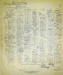
Map of Sidney Township in 1787 - 1981 rewrite
Fait partie de Map collection
A recopy of the 1787 map of Sidney Township. The original map entitled "Plan of the Township of Sidney in the District of Mecklinburg. Surveyed in 1787 by Lewis Kotts, with the names of the proprietor inserted in the Lots." The recopy was completed by Mrs. Dorothy Ashton in 1981, for the Corby Public Library and Hastings County Historical Society. Scale 40 chains to an inch.
Donated by the Belleville Public Library in 2014.
Sans titre

Fait partie de Map collection
A map of the Township of Thurlow, in 1787. Contains names of local property owners within their respective lots. Surveyed by Deputy Provincial Surveyor Lewis Kotte. Scale: 40 chains : 1 inch.
Sans titre

Fait partie de Map collection
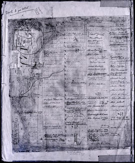
A map of Sidney Township, specifically the District of Mecklenburg in 1787. Contains information on the plans for the 1st, 2nd, and 3rd concessions, as well as property owners. Created by Lewis Kotte, Deputy Provincial Surveyor. Scale: 40 chains to an inch.
Sans titre
Map of Thurlow Township 1787 (with footnotes)
Fait partie de Map collection
A land grant map of the Township of Thurlow, in 1787. Contains names of local property owners within their respective lots and concessions 1-4. Footnotes around the waterfront were added c.1960. Dimensions: 22cm x 28cm.
Mecklenburg, District of Proclamation by George III, July 24, 1788 - Establishing same
Fait partie de HCHS Textual Records collection: Files 3500 to 3916
Proclamation made by George III on the formation of the District of Mecklenburg.
Fait partie de HCHS Textual Records collection: Files 3000 to 3499
This file contains a copy of a c.1788 Upper Canada Proclamation, made by Geo. Pownall. Mentioning; “The Bay of Quinty”and also with references the Trent River, Sidney Township.
Map of Townships by waterfront and Mohawk Territory
Fait partie de Map collection
Map showing townships by the waterfront of the Bay of Quinte and the Mohawk Territory. This area encompasses townships in both Prince Edward and Hastings Counties. Text on map says "District of Nassau." Dated 1790. Map copied from the Archives of Ontario.
Fait partie de HCHS Textual Records collection: Files 1500 to 1999
File contains an obituary of John Howard, reprinted from Gentlemen's Magazine March 1790.
Fait partie de HCHS Textual Records collection: Files 2500 to 2999
This file contains a newspaper article clipping by Viva Richmond Graham. this article about the correlation between the first settlers in Ontario, and the naming of new settlements, in the early years of the region surrounding the Hastings County.
Sans titre
Fait partie de HCHS Textual Records collection: Files 2500 to 2999
File contains photocopies of field notes dated 1791-92 of a survey of the Indian Lands on Grand River; the course of the Lake Ontario from Toronto to the River Trent; Head of the Bay of Quinty (sic). Donated by K.G.M. Ross
Spinning and Carding display cards
Fait partie de HCHS Textual Records collection: Files 2500 to 2999
This file contains a folding card display reflecting the changes of "spinning", over the many years, since the invention of spinning wheels.
Hay Bay Church; subscribers list, 1792
Fait partie de HCHS Textual Records collection: Files 1500 to 1999
File contains a subscription list from 1792 to build the Hay Bay Methodist Church in Adolphustown.
Meyers, John W. : petition for lot 4, 1792
Fait partie de HCHS Textual Records collection: Files 1500 to 1999
File contains a photocopied manuscript petition to Lt. Governor John Graves Simcoe by Captain John W. Meyers for the grant of lot no. 4 in Thurlow Township for the use and improvement by the Meyers family.
Sans titre
Fait partie de HCHS Textual Records collection: Files 2500 to 2999
File contains a document pertaining to the abolishment of slavery. The document is; "an Act to prevent the further introduction of slaves, and to limit the term of contracts for servitude within this province."
Osgoode, Lord Chief Justice, 1794
Fait partie de HCHS Textual Records collection: Files 2000 to 2499
File contains a photocopied manuscript message of congratulations to Lord Osgoode on his appointment as Chief Justice of Lower Canada in 1794.

Rawdon Township : diary of W. Hambly, 1793-1794
Fait partie de HCHS Textual Records collection: Files 2500 to 2999
File contains a reproduction of a manuscript diary of W. Hambly, surveyor, for the period 6 December 1793 to 1 May 1794. The diary entries discuss the survey process in Thurlow, Sidney, Huntingdon and Rawdon Townships. Also present is a typescript transcript of the diary with an appended footnote section which contains a glossary of terms.

Reproduction of a map of Upper Canada
Fait partie de Map collection
Reproduction of a map showing "the Routes Lt. Gov. J. G. Simcoe took on trips" throughout Upper Canada from March 1792 to September 1795. The map was charted by Lt. Gov. Simcoe. A good depiction of the area now referred to as Southern Ontario and his plans for a capital there - "London." This map was published as part of "Charting Our Past" from the Archives of Ontario by Stonehouse Publications.
Scale: about 20 miles to an inch.

Proposed Towns and Military Roads of Upper Canada
Fait partie de Map collection
Poor reproduction of a sketch of Upper Canada to show places designated by Lt. Gov. Simcoe for towns and proposed military roads, circa 1796. The map was published by B. M. Kings.
Deposition by John W. Myers 1797 for David Palmer
Fait partie de HCHS Textual Records collection: Files 3500 to 3916
This file contains a photocopy of a Deposition by John Walter Myers Esq. dated 14-June-1797 for David Palmer's service in the Corps known by the name of Major Roger's Corp. and that Catharine Harris (wife of David Harris) is David Palmer's legitimate daughter.